


Overview
Khairahani Municipality (खैरहनी नगरपालिका) was established in 2015 as a local level government. The headquarters of this municipality located in Khairahani, Chitwan district of Nepal. The Khairahani Municipality was established by merging the existing Khairahani, Kumroj, and Chainpur VDCs. At the time of the 1991 Nepal census, it had a population of 66,629 people living in 12983 households. The total area of this municipality is 85.57 square Km.
Khairhani Municipality (खैरहनी नगरपालिका, चितवन) is in Narayani zone under Central Development Region and about 18 km from Bharatpur, the district headquarters of Chitwan. Exists in the east. The municipality was formed as per the decision of the Government of Nepal dated 2071-01-25. The municipality consists of three village development committees including Chainpur, Khairhanir, and Kumroj of Chitwan district.
As per the decision of the Government of Nepal dated 2072-06-01, Khairhani Municipality is a joint form of the former four Village Development Committees after the Kathar Village Development Committee was included in this municipality.
Parsa Bazaar can be considered as the main market of Khairhani town. This market is also a major trading center of Chainpur, Bhandara, Kathar, Kumroz, Birendranagar, Pithuwa, and other nearby settlements. There are various legends about how Khairhani Municipality was named. It is said that the word khairghari, which was immediately known as khairghari, was changed to khairhani as the area was full of khair ghari in ancient times. The Khairhani Village Development Committee has been named after the same name and the municipality has been formed with the same Khairhani Village Development Committee.
About 190 m above sea level. This elevated municipality is divided into north and south parts by east-west highway. It is bordered by Shaktikhor and Siddhi to the north, Birendranagar to the east, Bhandara to the west, Ratnanagar municipality, and Chitwan National Park to the south. The Budhi Rapti River separates Khairhani as a natural boundary to the south. This area is very suitable for agriculture due to the arable soil brought regularly by the Rapti River and its tributaries.
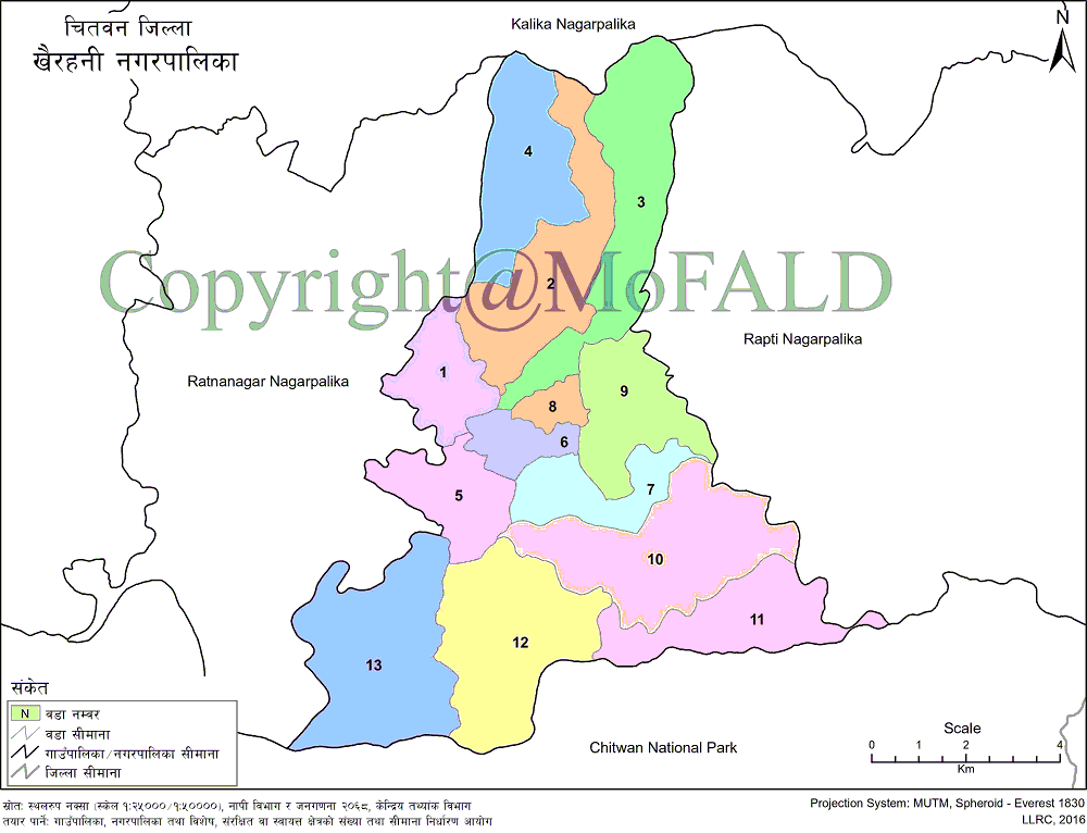
On political grounds, the city has been divided into 13 wards to provide administrative services to the local people. In addition, the municipality covers an area of 85.57 sq. Km. The area is occupied. In terms of constituencies, Khairhani Municipality is the No. 1 constituency as three constituencies have been established in Chitwan district for the House of Representatives. Similarly, this municipality is in both the constituencies out of the two constituencies in Constituency No. 1 for the Provincial Assembly. According to which Pradesh Sabha constituency no. There are 7 wards including wards 3, 6, 7, 8, 9, 10, and 11 under 1 (a) and ward no. There are 6 wards including 1, 2, 4, 5, 12, and 13.
Geographical Map of Khairahani Municipality:
Contact Address:
Location: Khairahani, Chitwan, Bagmati Pradesh, Nepal
Telephone: +977-56-582006
Email: [email protected]
Website: www.khairahanimun.gov.np