Overview
Dharche Rural Municipality (Gaupalika - धार्चे गाउँपालिका, गोरखा) in Gorkha District, under Gandaki Province, is home to indigenous communities, mainly followers of Bon, a nature-worshipping faith. The name “Dharche” is derived from two local words: “Dharj,” meaning “flag,” and “Gang,” meaning “hill.” Locals believe in placing flags on hilltops and riversides during departures or special prayers, symbolizing their deep connection with nature and spiritual traditions.
Cultural Identity and Tourism Slogan
Recognizing its rich natural and cultural heritage, the municipality has adopted the tourism slogan “Dharche – An Open Museum of Nature and Culture.” Another notable phrase is “For Tourists: Me; For Me: Tourism,” indicating the community's commitment to tourism-led development.
Geographic Details
-
Latitude/Longitude: 28.1357° N, 84.5228° E
-
Total Area: 652 square kilometers
-
Elevation Range: 630 to 7,309 meters above sea level
Administrative and Structural Overview
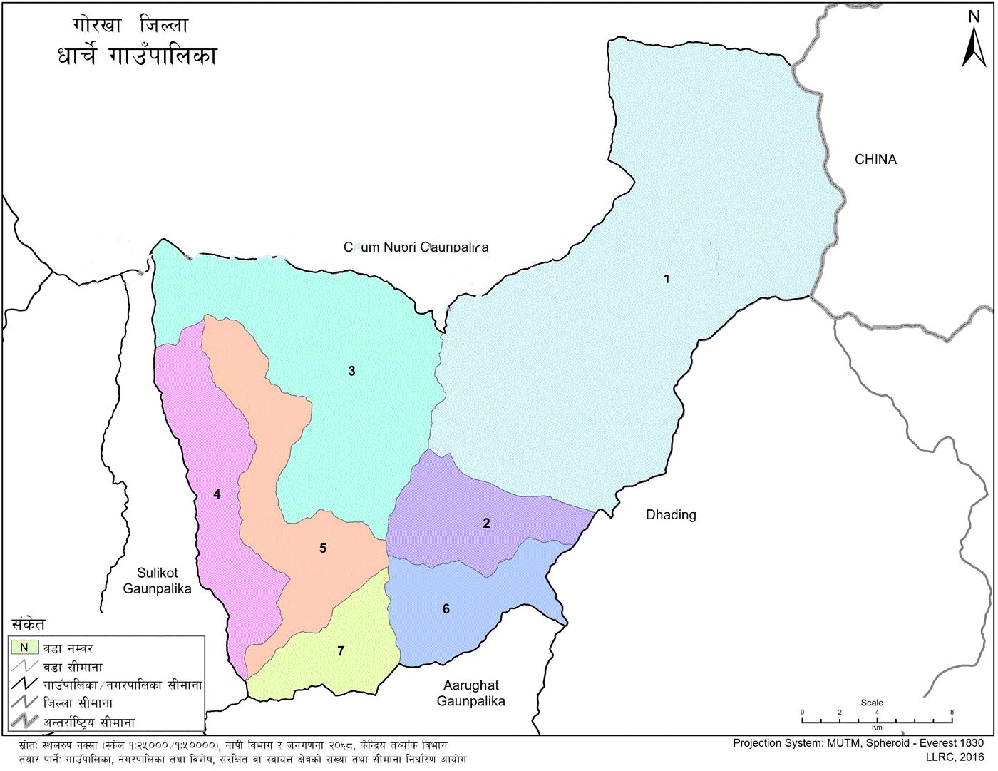
Dharche is divided into 7 wards and was formed by merging the previous VDCs of Kerauja, Uhiya, Laprak, Gumda, Kashigaun, and Lapu from the former Ilaka No. 12.
-
Eastern Border: Dhading District and Tibet, China
-
Western Border: Barpak Sulikot Rural Municipality
-
Northern Border: Chumnubri Rural Municipality
-
Southern Border: Aarughat Rural Municipality
Climate and Demographics
-
Temperature Range: 5°C (minimum) to 29°C (maximum)
-
Total Households: 3,932
-
Total Population: 18,724
-
Annual Population Growth Rate: 2.18%
Religious Composition
-
Bon
-
Buddhist
-
Hindu
-
Christian
Ethnic Distribution
-
Gurung: 83.9%
-
Ghale: 11%
-
Bishwakarma: 4.9%
-
Other ethnicities: 0.2%
Occupational Data
-
Agriculture: 40%
-
Wage Labor: 23%
-
Students: 22.5%
-
Foreign Employment: 7.5%
-
Other Professions: Remaining percentage
Land Use Distribution
-
Agricultural Land: 9.83%
-
Forest Area: 36.67%
-
Grasslands and Shrubs: 20%
-
Barren and Rocky Land: 30.38%
-
Snow-covered Area: 2.53%
-
The remaining includes ponds, lakes, etc.
Governance and Constitutional Provisions
The Constitution of Nepal (2072 BS) defines Nepal as a federal democratic republic, with power divided among federal, provincial, and local levels. Currently, there are 7 provinces and 753 local governments operating under this structure.
The constitution assigns 22 exclusive and 15 concurrent powers to local governments, ensuring the executive, legislative, and judicial branches. These rights help deliver democratic services, promote inclusion, and ensure representation of marginalized groups.
Local Government Functions
The Local Government Operation Act (2074) was introduced to implement constitutional mandates.
As per Chapter 6, Section 24(1) of the Act, every rural municipality is required to develop periodic and mid-term plans, followed by annual planning. Dharche Rural Municipality has formulated and implemented its periodic development plan in accordance with this provision.
Geographical and Administrative Facts
-
Coordinates: 28.1357° N, 84.5228° E
-
Area: 652 sq. km
-
Altitude: 630 to 7,309 meters above sea level
-
Number of Wards: 7
-
Formed by Merger of: Kerauja, Uhiya, Laprak, Gumda, Kashigaun, and Lapu
Bordering Entities
-
East: Dhading District
-
West: Barpak Sulikot Rural Municipality
-
North: Chumnubri Rural Municipality
-
South: Aarughat Rural Municipality
-
Northeast Border: Connects with China (Tibet Autonomous Region)
Climate and Population Status
-
Maximum Temperature: 29°C
-
Minimum Temperature: 5°C
-
Household Count: 3,932
-
Population: 18,724
-
Population Growth Rate: 2.18% annually
Religious and Ethnic Demographics
-
Religion:
-
Buddhist: Majority
-
Hindu: Second highest
-
Bon: Third
-
Christian: Least
-
-
Ethnicity:
-
Gurung: 83.9%
-
Ghale: 11%
-
Bishwakarma: 4.9%
-
Others: 0.2%
-
Economic Activity Overview
-
Agriculture: 40%
-
Daily Wage Labor: 23%
-
Students: 22.5%
-
Foreign Employment: 7.5%
-
Others: Remaining share
Land Utilization Breakdown
-
Cultivated Land: 9.83%
-
Forest Coverage: 36.67%
-
Grassland and Shrub Area: 20%
-
Barren and Rocky Land: 30.38%
-
Snow-covered Region: 2.53%
-
Lakes and Water Bodies: The Remaining portion