Babai Rural Municipality (Babai Gaupalika / Nepali: बबई गाउँपालिका) is a rural local government area in Dang District of Lumbini Province. It was formed by merging the former Panchkule and Purandhara VDCs and is organized into 7 wards. The rural municipality lies 46 kilometers west of Ghorahi, the district headquarters, and covers 257.48 square kilometers.
Babai has a mixed geographic, cultural, agricultural, and educational profile. Its land use is dominated by forest, while agriculture remains a main livelihood base. The municipality also has school-level institutions, one Tribhuvan University-affiliated campus, cultural communities, religious festivals, fairs, and natural sites such as Purandhara Waterfall. A related internal listing is available for Babai Rural Municipality local government services.
| Field | Details |
|---|---|
| Name: | Babai Rural Municipality |
| Nepali Name: | बबई गाउँपालिका |
| Local Name: | Babai Gaupalika |
| District: | Dang |
| Province: | Lumbini Province |
| Area: | 257.48 sq. km |
| Wards: | 7 |
| Formation: | Formed by merging former Panchkule and Purandhara VDCs |
| Established: | 2073/11/22 |
| Distance from District Headquarters: | 46 km west of Ghorahi |
| Population: | 30,968 |
| Male Population: | 14,446 |
| Female Population: | 16,522 |
| Literacy Rate: | 78.01% |
| Population Density: | 120 people per sq. km |
| Altitude Range: | 470 m to 1,891 m above sea level |
| Major Income Sources: | Agriculture and foreign employment |
| Major Tourist Site: | Purandhara Waterfall |
| College: | Purandhara Campus |
| University Affiliation: | Tribhuvan University |
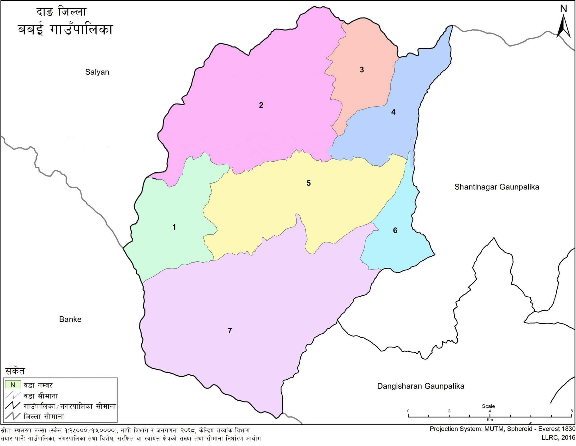
Babai Rural Municipality is located in Dang District under Lumbini Province. It is situated west of Ghorahi, the district headquarters, at a distance of 46 kilometers. Its location places it within the wider social, economic, and transport setting of western Dang.
The rural municipality is bordered by Shantinagar Rural Municipality and Dangisharan Rural Municipality to the east. Banke District lies to the west, Salyan District lies to the north, and Dangisharan Rural Municipality and Banke District lie to the south.
This boundary setting connects Babai with neighboring rural municipalities, nearby districts, agricultural exchange areas, forest-resource zones, and movement routes between hill and Terai regions.
Babai Rural Municipality was established under Nepal’s local restructuring process. According to the formation details, the Commission for the Determination of the Number and Boundaries of Village Bodies, Municipalities, and Special, Protected, or Autonomous Areas presented its report on 2073/09/22 under Article 295, Subsection (3) of the Constitution of Nepal.
A committee chaired by the Honorable Minister of Federal Affairs and Local Development submitted its report on 2073/11/20. After the government decision dated 2073/10/22, Babai Rural Municipality was established on 2073/11/22 by merging the former Panchkule and Purandhara VDCs. The rural municipality was organized into 7 wards.
This formation gives Babai its present administrative identity as a rural municipality within Dang District.
As per the 2021 census, Babai Rural Municipality has a total population of 30,968. The male population is 14,446, which accounts for 46.6% of the total. The female population is 16,522, which accounts for 53.4%.
The literacy rate is 78.01%. With an area of 257.48 square kilometers, the population density is 120 people per square kilometer.
These figures show a rural municipality with a moderate population size, a higher female population share, and a literacy base that supports planning in education, local services, and community development.
Babai Rural Municipality has an altitude range from 470 meters to 1,891 meters above sea level. This variation gives the municipality a mixed physical setting that includes Terai and Inner Madhes characteristics.
Land use in Babai is dominated by forest. Forest area covers 75.79% of the rural municipality, equal to 195.13 square kilometers. Arable land covers 13.53%, equal to 34.84 square kilometers. Shrubland covers 3.64%, or 9.37 square kilometers, while sandy land covers 4.38%, or 11.29 square kilometers.
Grazing land occupies 1.63%, or 4.19 square kilometers. Rivers, streams, and ponds cover 0.92%, or 2.37 square kilometers. Other land accounts for 0.10%, or 0.25 square kilometers.
This land-use pattern shows that forest resources are central to Babai’s physical profile. Agricultural land remains important, but it occupies a smaller share of the total area than forest.
Babai Rural Municipality has fertile soil suitable for agriculture. Loamy and clayey soils are found in the area. The main crops produced in the municipality include rice, wheat, maize, barley, mustard, potatoes, tobacco, sugarcane, lentils, peas, chickpeas, and soybeans.
Agriculture is a major livelihood source for households in Babai. The average household income is primarily linked to agriculture, while foreign employment is another major income source. The municipality has also seen an increasing trend of local manpower going abroad for labor and studies.
Agricultural development is connected with land quality, irrigation, access to seeds and fertilizers, use of tools, transport access, local markets, and household labor availability. The area has fertile land and multiple crop types, but several constraints affect production. These include limited access to modern agricultural technology, seeds, fertilizers, tools, and the high cost of required inputs.
The municipality also has scope for dairy production, poultry production, fish farming in ponds and rivers, and agriculture-based cottage industries. Water resources and rivers can support irrigation when managed through canals and suitable technologies.
Babai Rural Municipality has a varied climate due to its geographic diversity. The climate is categorized as tropical and subtropical. Since the municipality lies in the Terai and Inner Madhes regions, the air has relatively lower humidity compared with other Terai and eastern districts, making the climate feel dry.
The average maximum temperature can reach up to 36.3°C, while the average minimum temperature is 4.8°C. Summer is generally hot, and winter is mildly cold.
The average annual rainfall is 548 mm. Most rainfall occurs during Asar, Shrawan, and Bhadra. Rainfall is influenced by monsoon winds from the Bay of Bengal during the monsoon period. During winter, occasional rainfall occurs due to western monsoon winds.
Although the municipality has rivers, streams, and ponds, many of these water bodies dry up during summer, especially before the monsoon season. This seasonal water pattern affects agriculture, irrigation, and local resource use.
Agriculture is the main economic base of Babai Rural Municipality. Many households depend on farming, livestock, and related rural activities. Foreign employment is another important income source, and the trend of going abroad for work and studies is increasing.
The municipality has development areas linked to trade, small-scale industries, training centers, financial services, fish farming, modern agriculture, and agriculture-based enterprises. Dairy and poultry production can support household income when transport services reach farmers and when collection, chilling, and processing systems are developed.
Natural resources also shape the local economy. Forests, fertile land, water resources, and biodiversity form a base for livelihood activities. Community forest user groups, non-timber forest products, herbs, and honey production are identified as areas that can support income when organized and linked with markets.
At the same time, unemployment remains a concern. The lack of sufficient employment opportunities in government and non-government sectors contributes to interest in foreign employment. Skill-based training and integrated employment activities are relevant to the municipality’s economic planning.
Babai Rural Municipality provides education from basic level to higher education. Institution statistics in Babai show 41 total schools, including 34 public schools and 7 private schools. The municipality also has 1 technical school and 1 college.
The school-level distribution includes 39 pre-school institutions, 37 basic-level schools, 13 secondary schools, and 4 plus-two schools. These figures show that basic education coverage is wider than secondary and plus-two coverage.
Purandhara Campus is located at Purandhara-5, Hansapur, Babai, Dang. It offers bachelor-level education and is affiliated with Tribhuvan University.
The presence of school-level institutions and a university-affiliated campus makes education part of Babai’s public service and development profile. School access, continuation to secondary level, and higher education access remain important for students, parents, and local planners.
| Institution and Location | Level / Program | Type / Affiliation |
|---|---|---|
| Janakalyan Secondary School - Padampur, Babai-5, Dang | Nursery - 12 | Public |
| Janata Secondary School, Hansapur - Hansapur, Babai-3, Dang | Nursery - 12 | Public |
| People's Land Secondary English Boarding School - Hapure, Babai-4, Dang | Grade 1 - 10 | Private |
| Purandhara Everest Academy - Babai-3, Dang | Nursery - 10 | Private |
| Great Ideal English Boarding School - Babai-4, Dang | Nursery - 10 | Private |
| Purandhara Academy - Babai-3, Dang | Nursery - 9 | Private |
| Saraswoti Secondary School - Charakmatiya, Babai-7, Dang | Nursery - 12 | Public |
| Modern Digdarshan Academy - Kaushilapur, Babai-6, Dang | Nursery - 10 | Private |
| Saraswoti Janata Secondary School - Gangate, Purandhara, Babai-1, Dang | Nursery - 12 | Public |
| Shree Janata Secondary School - Babai-5, Dang | Nursery - 10 | Public |
| Naba Jyoti Janata English School - Charakmatiya, Babai-7, Dang | Grade 1 - 10 | Private |
| Jana Kalyan Basic School Bhangabari - Babai-1, Dang | Nursery - 8 | Public |
| Nepal Rastriya Basic School - Babai-2, Dang | Nursery - 8 | Public |
| Janashram Basic School - Babai-4, Dang | Nursery - 8 | Public |
| Bhanu Bhakta Secondary School - Babai-6, Dang | Nursery - 10 | Public |
| Parijat Smriti Vidhyalaya - Babai-5, Dang | Nursery - 2 | Private |
| Shree Deuti Secondary School - Tallo Malai, Babai-7, Dang | Nursery - 10 | Public |
| Pragatisil Basic School - Babai-5, Dang | Nursery - 4 | Public |
| Shree Siddheshori Basic School - Babai-7, Dang | Nursery - 8 | Public |
| Janashram Saraswoti Basic School Jaubari - Babai-5, Dang | Nursery - 5 | Public |
| Janata Basic School - Jila, Babai-1, Dang | Nursery - 8 | Public |
| Siddhi Ganesh Basic School - Sundarkhal, Babai-4, Dang | Nursery - 4 | Public |
| Sudha Shah Basic School - Katkuiya, Babai-6, Dang | Nursery - 8 | Public |
| Lok Kalyankari Basic School - Babai-1, Dang | Nursery - 5 | Public |
| Janashram Basic School - Babai-5, Dang | Nursery - 5 | Public |
| Laxmi Basic School Kaptane - Babai-1, Dang | Nursery - 5 | Public |
| Jana Jyoti Basic School Khayarbhatti - Babai-5, Dang | Nursery - 4 | Public |
| Surya Bal Kalyan Basic School Patihalna - Babai-1, Dang | Nursery - 5 | Public |
| Loktantrik Basic School Kanchanpur - Babai-4, Dang | Nursery - 4 | Public |
| Janashakti Primary School - Bijayaneta, Babai-2, Dang | Nursery - 5 | Public |
| Nepal Rastriya Basic School - Babai-2, Dang | Nursery - 5 | Public |
| Jana Bikash Basic School Ghattekhola - Babai-3, Dang | Nursery - 3 | Public |
| Jana Kalyan Basic School - Babai-7, Dang | Nursery - 3 | Public |
| Saraswoti Basic School - Jaljala, Babai-7, Dang | Nursery - 5 | Public |
| Babai Basic School - Dhobhaghat, Babai-1, Dang | Nursery - 4 | Public |
| Srijanshil Basic School Kuireni - Babai-1, Dang | Nursery - 4 | Public |
| Laxmi Jana Basic School Supare Ratamata - Babai-3, Dang | Nursery | Public |
| Deurali Basic School Banchare - Babai-1, Dang | Nursery - 3 | Public |
| Suryjyoti Basic School - Babai-6, Dang | Nursery | Public |
| Jana Jyoti Basic School - Babai-7, Dang | Nursery | Public |
| Sibashakti Basic School - Babai-7, Dang | Nursery | Public |
| Purandhara Campus - Purandhara-5, Hansapur, Babai, Dang | Bachelor Level | Tribhuvan University |
| Category | Count | Remarks |
|---|---|---|
| Total Schools | 41 | Includes public and private schools |
| Public Schools | 34 | Community/public institutions |
| Private Schools | 7 | Institutional/private schools |
| Technical School | 1 | Technical stream/institution count |
| College | 1 | Purandhara Campus |
| University Affiliation | 1 | Tribhuvan University-affiliated campus |
| Level | Grade / Range | Number of Schools |
|---|---|---|
| Pre-school | Nursery / ECD | 39 |
| Basic | Nursery/Grade 1 - 8 | 37 |
| Secondary | Grades 9 - 12 | 13 |
| Plus Two | Grades 11 - 12 | 4 |
The education listing for Babai includes several community schools across different wards. Some listed institutions include Lok Kalyankari Basic School in Babai-1, Janashram Basic School in Babai-5, Laxmi Basic School Kaptane in Babai-1, Jana Jyoti Basic School Khayarbhatti in Babai-5, Surya Bal Kalyan Basic School Patihalna in Babai-1, Loktantrik Basic School Kanchanpur in Babai-4, and Janashakti Primary School in Bijayaneta, Babai-2.
Other listed institutions include Nepal Rastriya Basic School in Babai-2, Jana Bikash Basic School Ghattekhola in Babai-3, Jana Kalyan Basic School in Babai-7, Saraswoti Basic School in Jaljala, Babai-7, Babai Basic School in Dhobhaghat, Babai-1, and Srijanshil Basic School Kuireni in Babai-1.
The presence of these institutions across wards indicates the role of community schools in local education delivery.
Babai Rural Municipality has diverse communities, ethnic groups, and religious traditions. Festivals celebrated in the municipality include Dashain, Tihar, Maghi, Holi, Maha Shivaratri, Ram Navami, Krishna Janmashtami, Bakr Eid, Aitabari, Buddha Jayanti, and Christmas.
A wider festival list also includes Haritalika, Shree Panchami, Vivaha Panchami, Chhath, Chaite Dashain, Saune Sakranti, Matatirtha Aunsi, Akshaya Tritiya, Harishayani-Haribodhini Ekadashi, Nag Panchami, Raksha Bandhan, Kushe Aunsi, Balachaturdashi, Kojagrat Purnima, Shri Swasthani Purnima, Karkat Sankranti, Sankat Puja, Eid, Bakrid, Eid ul-Fitr, Christmas Day, and the English New Year.
Religious and cultural fairs are also part of local life. Suwakoti Mela, Shivaratri Mela, and Barah Mela are among the major fairs held in and around the municipality.
The Magar community accounts for 18.94% of the population of Babai Rural Municipality. The Magar community has cultural practices, attire, dances, musical instruments, songs, and games that are part of the municipality’s cultural identity.
Traditional Magar dances include Bhume, Seridde, Damphuya, Sorathi, Tappa, Bayaldhari, Mamai, and Singaru. Traditional attire is also described as part of Magar cultural life, though the use of traditional clothing is decreasing and is now more visible during festivals and formal events.
The Tharu community accounts for 4.07% of the total population. Tharu culture is also part of Babai’s heritage. The Tharu community is associated with indigenous lifestyles, knowledge, customs, and social practices. The Mukhiya, Badhghar, or Chaudhary system continues within the Tharu community. Traditional Tharu settlement patterns and earthen houses are also part of the cultural description of the municipality.
The cultural profile of Babai includes both continuity and change. Some cultural forms, art, and traditions require study and conservation due to changes caused by modern lifestyles and interaction among different cultural groups.
Babai Rural Municipality has natural features such as rivers, streams, ponds, wetlands, forests, and greenery. Among the rivers, lakes, and waterfalls in the municipality, Purandhara Waterfall is identified as a tourist attraction.
Tourism in Babai is linked with natural sites and cultural identity. The municipality has cultural tourism possibilities through Magar and Tharu heritage, local dances, attire, food traditions, festivals, and fairs.
Tourism development in Babai is tied to conservation, access, local participation, and service planning. Any tourism activity should remain connected with the protection of natural resources and cultural practices.
Babai Rural Municipality has several identified areas for development. Water resources and rivers can support irrigation through canals and other suitable technologies. Improved irrigation can support agricultural production and reduce dependence on rainwater.
Road improvement is another important area. Upgrading local dirt roads to blacktop roads can improve transport services and help farmers, students, service users, and local enterprises.
Commercial agriculture is also identified as a suitable direction. Vegetables, livestock, and other agricultural products can support local income when production, transport, and market access are managed properly.
Small cottage industries and agriculture-based industries can support local employment. The presence of religious and cultural sites also supports tourism-related planning. Government, cooperative, non-governmental, and private organizations are active in the area, which creates room for partnerships in local development.
Industry, trade, and commerce are also listed as possible development areas due to the increasing number of consumers in the municipality.
Babai Rural Municipality has natural resources such as forests, fertile agricultural land, water resources, and biodiversity. These resources support agriculture, forest-based livelihoods, environmental planning, and rural enterprise development.
The municipality also has an increasing educated human resource base and a dominant youth population. These factors matter for education, skill training, employment planning, entrepreneurship, and public service improvement.
Connection to the national highway system is another listed opportunity. Road connection can support mobility, market access, education access, health access, and agricultural exchange.
Small-scale and cottage industries based on agriculture and herbs are also relevant to the municipality’s development profile. Tourism development is another area connected with natural and cultural resources.
Babai Rural Municipality faces several challenges in social and physical development. There is a lack of necessary employment-generating industries and factories within the municipality. This limits local job creation and contributes to dependence on other income sources, including foreign employment.
Drinking water and public toilet management require attention. Many roads within the municipality are unpaved and of low quality, which affects transport, market access, and service delivery.
Although the municipality has arable land, commercial farming has not developed fully. Agriculture remains affected by traditional systems, dependence on rainwater for irrigation, limited access to inputs, and weak use of improved technology.
The lack of income sources affects development work. Settlement development is not sufficiently organized, and planned settlement development remains weak. Environmental protection and waste management also need clearer planning.
These challenges show that Babai’s planning priorities are closely connected with roads, irrigation, employment, agriculture, settlement management, drinking water, sanitation, and environmental protection.
Babai Rural Municipality is connected with nearby local governments and regional institutions through transport, migration, agricultural and livestock products, forest resources, tourism, employment, education, health, and natural resource management.
The municipality has coordination with neighboring local bodies such as Dangisharan Rural Municipality, Shantinagar Rural Municipality, Kalimati Rural Municipality of Salyan District, and the District Coordination Committee Dang. Relations with national and international non-governmental organizations are also part of the local development context.
These connections matter because local development does not operate within one boundary alone. Movement of people, goods, students, workers, forest products, and agricultural products links Babai with surrounding areas.
Babai Rural Municipality is located in Dang District of Lumbini Province. It lies 46 kilometers west of Ghorahi, the district headquarters.
Babai Rural Municipality was formed by merging the former Panchkule and Purandhara VDCs. It was established on 2073/11/22 and organized into 7 wards.
As per the 2021 census, Babai Rural Municipality has a total population of 30,968, including 14,446 males and 16,522 females.
The literacy rate of Babai Rural Municipality is 78.01%.
Agriculture is the primary household income source, and foreign employment is another major source of income.
Major crops include rice, wheat, maize, barley, mustard, potatoes, tobacco, sugarcane, lentils, peas, chickpeas, and soybeans.
Yes. Purandhara Campus is located at Purandhara-5, Hansapur, Babai, Dang. It offers bachelor-level education and is affiliated with Tribhuvan University.
Purandhara Waterfall is identified as a tourist attraction in Babai Rural Municipality.
Major challenges include limited employment-generating industries, drinking water and public toilet management issues, unpaved roads, weak commercial farming, rain-fed irrigation, traditional agriculture, unplanned settlement development, and weak environmental and waste management planning.



.jpg)