


Overview
Bhume Rural Municipality (Gaupalika - भूमे गाउँपालिका, रूकुम पूर्व) is one of the local levels established under Article 295 (3) of the Constitution of Nepal. Located in Rukum (East) District of Lumbini Province, this rural municipality was formed by merging the former Village Development Committees (VDCs) of Mahat, Kankri, Morabang, Kanda, Chunbang, and Ward No. 4 of Rukumkot VDC. It spans an area of 273.67 square kilometers and has a population of 19,829.
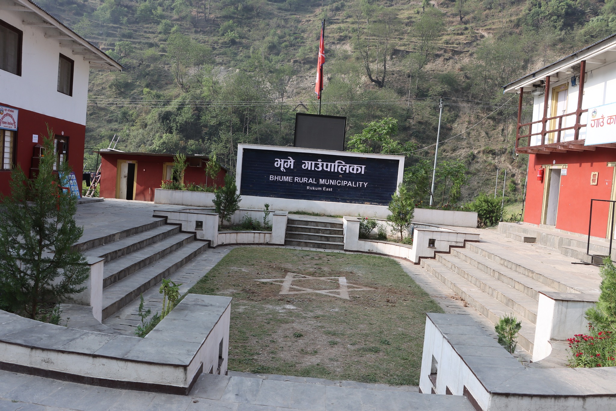
Bhume is bordered by Baglung District to the east, Sisne Rural Municipality and Musikot Municipality to the west, Putha Uttarganga Rural Municipality to the north, and Rolpa District to the south. The rural municipality has 9 ward offices, and its administrative center is located at Khawangbagar in Ward No. 2.
The first local level election was held on 14 Ashadh 2074 (28 June 2017), following which elected representatives took oath and assumed office. All 9 ward offices are operational, and services are being provided close to the local communities through the respective Ward Chairs and Ward Secretaries.
Key Highlights
| Key Information | Details |
|---|---|
| Location | Rukum (East), Lumbini Province |
| Province | Lumbini Province |
| Area | 273.67 square kilometers |
| Population (2068 BS Census) | 18,589 |
| Population (2078 BS Preliminary) | 19,835 (9,425 females; 10,410 males) |
| Number of Wards | 9 |
| Administrative Center | Khawangbagar, Ward No. 2 |
| Bordering Regions | East: Baglung District West: Sisne & Musikot North: Putha Uttarganga South: Rolpa |
| Elevation Range | 1,800 – 3,095.97 meters above sea level |
| Major Ethnic Group | Magar |
| Naming Origin | Derived from the traditional “Bhumya” festival |
| Cultural Significance | Rich Magar heritage, language, rituals, dances, and annual festivals |
| Main Occupation | Agriculture (cash crops), forestry, small industries, trade |
| Road Connectivity | Mid-Hill Highway passes through the municipality |
| Local Government Establishment | First election held on 14 Ashadh 2074 BS; renewed on 30 Baisakh 2079 BS |
| Number of Schools | 41 schools (33 public + 8 institutional) |
| Child Development Centers | 29 |
| Community Learning Centers | 4 |
Formation and Governance Structure
Bhume Rural Municipality was established under Article 295 (3) of the Constitution. It is composed of the former VDCs of Mahat, Kankri, Morabang, Kanda, Chunbang, and Ward No. 4 of Rukumkot VDC. According to the 2068 BS (2011 AD) census, the population was 18,589, spread over an area of 273.67 square kilometers.
As per the latest reorganization, its administrative center, initially in Morabang, was relocated to Khawang Bazaar in Ward No. 2 based on a recommendation by the rural assembly and a decision by the Government of Nepal, published in the Nepal Gazette.
Local elections were held again on 30 Baisakh 2079 (13 May 2022), ensuring the full functioning of the local government. With the presence of elected officials, including the Chairperson, Vice-Chairperson, Ward Chairs, and committee members, services are being delivered from the municipal and ward offices. The local government is functioning actively through its village assembly, executive, judicial committee, and sectoral committees.
Cultural Identity
The Magar community predominantly inhabits Bhume Rural Municipality. Its name is derived from the traditional “Bhumya” festival, during which locals worship the land (Bhumi) every year on the 1st of Ashadh. This festival includes the presentation of the annual village income and expenses, replacement of local representatives and messengers (Mijhar), and is celebrated for 3 to 7 days in different villages. Hence, the municipality was named after this important cultural event.
Bhume is culturally rich with strong ties to Magar traditions, language, dances, and rituals. It represents unity in diversity and holds significant potential in agriculture (especially cash crops), forestry, the environment, cottage industries, and both natural and artificial tourism. The Mid-Hill Highway passes through the area, enhancing trade and connectivity.
Geographical Location
Formerly under the Mid-Western Development Region’s Rapti Zone, the Rukum District was divided during federal restructuring. Rukum (West) became part of Karnali Province, while Rukum (East) remained in Lumbini Province.
Geographically, Bhume lies between latitudes 644,053.78 and 3,180,453.70 North, and longitudes 28.74 to 82.47 East. It ranges in elevation from 1,800 to 3,095.97 meters above sea level, covering an area of 273.67 square kilometers. The terrain is divided into hills, highlands, and mountainous regions.
Bhume is bordered by:
-
East: Baglung District
-
West: Sisne Rural Municipality and Musikot Municipality
-
North: Putha Uttarganga Rural Municipality
-
South: Rolpa District
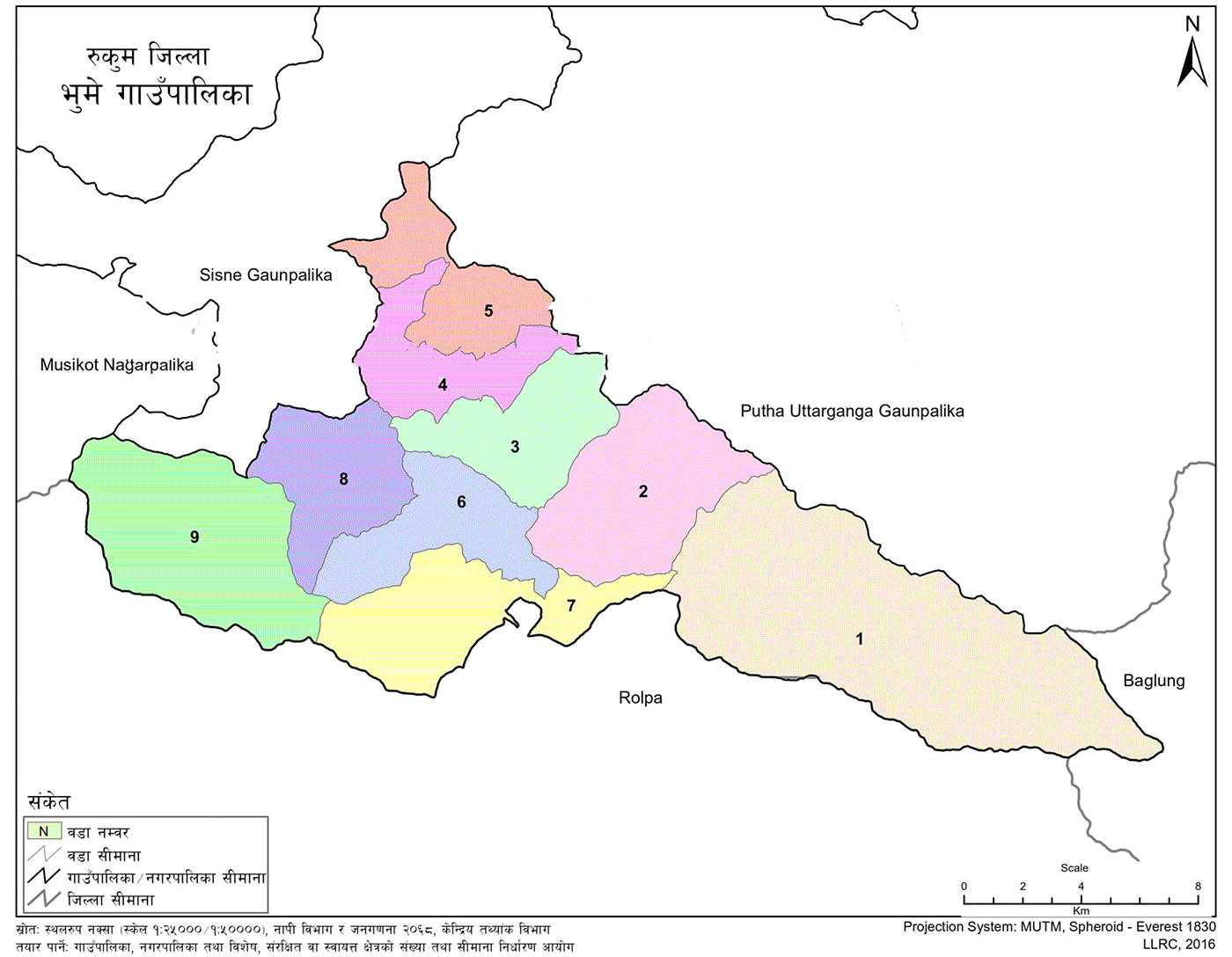
Political and Administrative Division
Bhume is divided into 9 wards and comprises:
-
5 former VDCs: Mahat, Kankri, Morabang, Kanda, Chunbang
-
Ward No. 4 of Rukumkot VDC
As per the 2068 BS census, the population was 18,589, while the preliminary results of the 2078 BS census show:
-
Households: 3,849
-
Total population: 19,835
-
Female: 9,425
-
Male: 10,410
The administrative center was relocated from Morabang to Ward No. 2, Khawangbagar, as per the decision published in the Nepal Gazette (Volume 67, Issue 57, Part 5, dated 2074/11/14).
Education in Bhume Rural Municipality
Educational Institutions
-
Secondary Schools (+2): 4
-
Lower Secondary Schools (Grades 1–10): 3
-
Primary Schools (Grades 1–8): 6
-
Primary Schools (Grades 1–7): 3
-
Primary Schools (Grades 1–5): 17
-
Institutional Schools (Grades 1–5): 1
-
Total Schools: 41
-
Child Development Centers: 29
-
Community Learning Centers: 4
School Positions and Class Operations
-
Pedi Primary School, Dharamshala (Ward 9): Grades 1–5
-
Duvachaur Primary School, Chunbang (Ward 9): Grades 1–5
-
Simchaur Primary School, Chunbang (Ward 9): Grades 1–5
-
Nepal National Secondary School, Chunbang (Ward 9): Grades 1–12
-
Sunny Primary School, Galmachhin (Ward 9): Grades 1–5
-
Madan Memorial School, Dandagau (Ward 9): Grades 1–3
-
Tribhuvan Primary School, Khawang (Ward 2): Grades 1–7
-
Janajagriti Secondary School, Mahat (Ward 6): Grades 1–12
-
Mahat Primary School, Labang (Ward 7): Grades 1–5
-
Janchetana Primary School, Khamdai (Ward 7): Grades 1–5
-
Baraha Primary School, Syala (Ward 1): Grades 1–7
-
Namuna Primary School, Moribang (Ward 3): Grades 1–7
-
Martyr Shukra Secondary School, Sima (Ward 3): Grades 1–12
-
Child Development Center (Ward 2): Grades 1–5
-
Taksar Primary School, Jhumlabang (Ward 3): Grades 1–8
-
Martyr Memorial School, Kyadsi (Ward 3): Grades 1–8
-
Bhumi Primary School, Rujikhola (Ward 1): Grades 1–5
-
Triveni Secondary School, Kankri (Ward 2): Grades 1–10
-
Himalaya Primary School, Gawang (Ward 2): Grades 1–5
-
Sidbachaur Secondary School, Lukum Kankri (Ward 1): Grades 1–12
-
Baljyoti Primary School, Dahabang (Ward 2): Grades 1–5
-
Nepal National Primary School, Korja: Grades 1–8
-
Saraswati Primary School, Simkhola (Ward 8): Grades 1–8
-
Janjyoti Primary School, Mahat (Ward 7): Grades 1–8
-
Bal Janjagaran School, Risalchaur: Grades 1–8
-
Binam Primary School, Mahat (Ward 7): Grades 1–5
-
Janshakti Secondary School, Kanda (Ward 4): Grades 1–10
-
Janata Primary School, Serabang (Ward 5): Grades 1–5
-
Janvikas Primary School, Tallosakim (Ward 4): Grades 1–5
-
Basic School, Daliwang (Ward 5): Grades 1–5
-
Kurchiwang Secondary School: Grades 1–10
-
Basic School, Jhimka (Ward 8): Grades 1–3
-
Balbikash Primary School, Gothibang (Ward 9): Grades 1–3

.jpg)


