


Overview
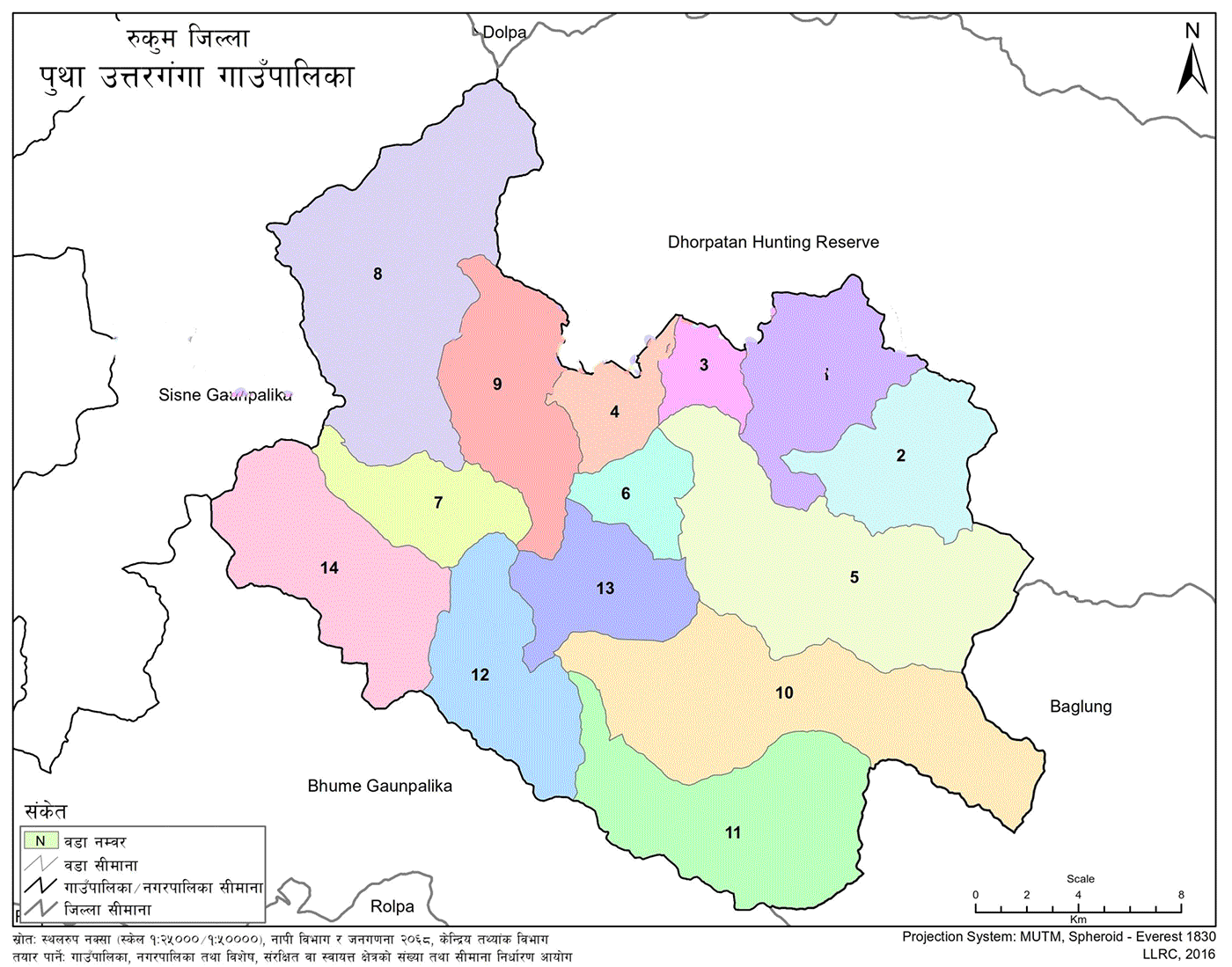
Putha Uttarganga Rural Municipality (Gaunpalika - पुथा उत्तरगङ्गा गाउँपालिका, रुकुम पूर्व) is located in Rukum East District of Lumbini Province. It was formed by merging six former Village Development Committees (VDCs): Ranmamaikot, Hukam, Takasera, Jang, Kol, and Ransi. Covering an area of 560.34 square kilometers, the rural municipality has a total population of 18,954.
It is bordered by Baglung and Myagdi districts to the east, the Sisne Himal of Sisne Rural Municipality to the west, Dolpa district to the north, and Bhume Rural Municipality to the south. The administrative center is located in Ward No. 10, Takasera. It comprises a total of 14 wards—the highest number of wards among any rural municipality in Nepal.
Key Highlights
| Category | Details |
|---|---|
| Province | Lumbini Province |
| District | Rukum East |
| Total Area | 560.34 sq. km |
| Total Population | 18,954 |
| No. of Wards | 14 (highest number among rural municipalities in Nepal) |
| Administrative Center | Ward No. 10, Takasera |
| Former VDCs Merged | Ranmamaikot, Hukam, Takasera, Jang, Kol, Ransi |
| Elevation Range | 1,210 m – 4,960 m above sea level |
| Geographical Coordinates | 28°39′28″ N, 82°48′25″ E |
| Climate | Cold to very cold (Himalayan and high hill regions) |
| Major Rivers and Streams | Uttarganga, Sanibheri, Pelpa, Bahule, Ghustung, Ranma, Arjal |
| Drainage Type | Dendritic (tree-like) drainage pattern |
| Forest Types | Rhododendron, Deodar, Pine, Oak, Maple, Himalayan shrubs |
| Wildlife Species | Musk deer, leopard, Himalayan monal, bear, monkey, wild boar |
| Medicinal Plants | Yarsagumba, Panchaunle, Chiraito, Silajit, Satwa, Atis |
| Main Agricultural Valleys | Takasera, Kol, Ransi, Jang |
| Major Tourist Attractions | Putha Himal, Sundo Lake, Rakshas Lake, Havatigala Cave, Baraha Tal |
| Cultural Events | Bumya Dance, Sera Baluwa Jatra, Triveni Mela, Kartik Purnima at Kharkhola |
| Nearest Provincial Capital | Dang Deukhuri (approx. 73.3 km south) |
| Nearest Federal Capital | Kathmandu (approx. 263 km east-southeast) |
| Natural Tourism Potential | Caves, lakes, waterfalls, ridgelines, and alpine pasturelands |
| Religious Sites | Ramazhi Baraha Than, Jalpa Tal, Sunpani Cave, Raktakund |
| Travel Accessibility | Geographically remote, limited road and air access |
| Eco-Tourism Potential | High due to pristine rivers, diverse terrain, and unique ecosystems |
| Main Challenges | Steep slopes, erosion risk, and underdeveloped infrastructure |
Geographical Location
The municipality lies in the eastern part of Rukum East and was officially established on Falgun 27, 2073 B.S. It stretches from the lowland region of Deukhola to the high peaks of Putha Himal, ranging in elevation from approximately 1,210 meters to 4,960 meters above sea level.
-
Latitude: 28°39′28″ N
-
Longitude: 82°48′25″ E
-
Area: 560.24 sq. km (48.25% of Rukum East’s total area)
The terrain is mountainous, with most settlements located along ridges and river valleys. Due to its high altitude, it remains relatively isolated with limited road and air connectivity. It lies approximately 263 km northwest of Kathmandu and 73.3 km north of the provincial capital, Dang Deukhuri.
Landform and Terrain Classification
The land composition includes steep hills, valleys, and rocky outcrops. The elevation variance results in diverse climate zones and ecosystems. Terrain classification is as follows:
-
Upper Slopes: 25,348 hectares (45.25%)
-
Lower Slopes: 22,093 hectares (39.44%)
-
Valleys: 4,603 hectares (8.22%)
-
Rocky Areas: 2,076 hectares (3.71%)
-
Himalayan Region: 1,769 hectares (3.16%)
-
Ridges and Peaks: 134 hectares (0.24%)
Slope analysis shows:
-
0–10°: 1,290 hectares (2.30%)
-
10–20°: 5,007 hectares (8.94%)
-
20–30°: 14,758 hectares (26.34%)
-
30–45°: 28,456 hectares (50.79%)
-
Above 45°: 6,513 hectares (11.62%)
Areas above 30° are considered erosion-prone and landslide-sensitive, especially when used for agriculture or settlements.
Climate Conditions
The area experiences cold to very cold climatic conditions, particularly in the highlands such as Putha Himal, Sundo Lake, Rakshas Lake, and other northern settlements. Areas like Mayang, Arjal, Ransi, and Jang have a cold temperate climate.
Water Resources and Drainage System
Key water sources originate from Myagdi’s Jaljala and Baglung’s Baula Khola and flow through various streams into the Dhorpatan Valley. The main rivers and streams include:
-
Pelpa Khola: 33.85 km
-
Uttarganga River: 24.84 km
-
Sanibheri River: 11.68 km
-
Other Streams: Bahule (9.06 km), Sisne (9.33 km), Okhma (7.14 km), Ghustung (6.67 km), Mukhba (6.44 km), Ghatte (6.42 km), Damchai (6.25 km), Ranma (4.90 km)
The drainage system primarily follows a dendritic (tree-like) pattern and flows from the south to the north, making it suitable for hydroelectricity and eco-tourism. These rivers and tributaries support irrigation in several wards and have untapped potential for agriculture and sanitation uses.
Natural Vegetation and Wildlife
Due to its diverse altitudes and climates, the municipality hosts a wide range of flora and fauna. Notable vegetation includes:
-
Trees: Rhododendron, Oak, Pine, Deodar, Walnut, Maple
-
Medicinal Herbs: Yarsagumba, Panchaunle, Chiraito, Silajit, Satwa, Atis
-
Fruits: Apple, Walnut, Orange, Peach
Common wildlife includes wild boar, musk deer, tiger, bear, leopard, monkey, and several bird species such as Himalayan Monal, Kalij, and vultures.
Vegetation Distribution by Forest Type:
-
Temperate Himalayan Chestnut Forest: 12,305 ha (25.04%)
-
Deodar Forest: 11,721 ha (23.85%)
-
Lower Temperate Chestnut: 9,539 ha (19.41%)
-
Rhododendron Forest: 6,055 ha (12.32%)
-
Broadleaf Pine Forest: 3,516 ha (7.15%)
-
Temperate Cedar: 1,310 ha (2.66%)
-
Deodar and Spruce: 1,306 ha (2.66%)
-
Khote Pine: 601 ha (1.22%)
-
Upper Temperate Pine: 597 ha (1.21%)
-
Oak-Maple Forest: 547 ha (1.11%)
-
Alpine Grassland: 202 ha (0.41%)
Tourism in Putha Uttarganga
Despite lacking access to the national highway, Putha Uttarganga has great tourism potential due to its natural, historical, religious, and cultural richness. Key tourist destinations include:
-
Natural Attractions: Hampa Danda, Havatigala Cave, Jharlung Hot Springs, Dunge Pokhari, Daral Gorge, Sundo Lake, Rakshas Lake, Seto Rato Tal, Jhakri Dhunga, Jalpa Tal, Raktakunda
-
Hiking & Mountain Views: Putha Himal, Puphal Bukipatan, Sisne Himal, Dhaulagiri Range
-
Historical & Religious Sites: Baraha Than, Namchengaun, Ramri, Resala Danda, Mandali Than, Siddha Than, Sunpani Cave
-
Cultural Practices: Traditional dances, festivals like Bumya Nach, Sera Baluwa Jatra, Triveni Jatra, and Kartik Purnima celebration at Kharkhola
While the municipality attracts both domestic and international tourists, the absence of a formal registry and lack of structured hospitality facilities limits potential growth. Expanding local homestays based on ethnic architecture and improving infrastructure could significantly enhance tourism.
Highlighted Tourist Spots in List Format:
-
Tato Pani (Hot Springs) – Wards 1, 2, 6
-
Dunge Pokhari – Ward 5
-
Ramazhi Baraha Than – Ward 6
-
Namchengaun, Ramri – Ward 2
-
Sundo Lake – Ward 3
-
Resala Danda – Ward 10
-
Jalpa Tal – Ward 5
-
Baraha Tal – Ward 2
-
Sunpani Cave – Ward 12
-
Raktakund – Ward 9
-
Boksa Lake – Ward 9
-
Prabhu Cave – Ward 9
-
Havatigala Cave – Ward 1
-
Sendanku Bas – Ward 11
-
Puphal Lake – Ward 3
-
Gumja Waterfall – Ward 2
-
Naudhari Waterfall – Ward 3
-
Rakse Lake – Ward 3
-
Lisne Gorge – Ward 8
-
Cherapanga Cave – Ward 11

.jpg)


