


Overview
According to Article 195, Clause 3 of the Constitution of Nepal 2072, Chhatrakot Rural Municipality (Gaupalika - छत्रकाेट गाउँपालिका, गुल्मी) is one of the 12 local governments in Gulmi District.
This municipality, known for its historical, religious, and cultural significance, is located between the Resunga Hill—where Rishi Ringa meditated—and the Shringalek, associated with Sage Shringi. Its name originates from the Chhatrakot Devalaya situated on the Choyga hilltop in Ward No. 3.
Historical Significance
A remarkable legend links Chhatrakot with the aftermath of the Kurukshetra war from the Mahabharata. During the review of the war, Bhim and Arjun boasted that victory was achieved due to their strength and valor. To correct this arrogance, Lord Krishna led the Pandavas to the beheaded head of the king of Uluk Vakhari, who had observed the entire war through divine insight.
The king's head revealed that Lord Krishna played the most crucial role in the war's outcome. Embarrassed, Bhim and Arjun realized their pride.
When Krishna asked the head for its wish, it expressed a desire to reside atop the high hills of Uluk. Granting the wish, Krishna blessed that all devotees who offer prayers there would be free from suffering and attain peace and prosperity.
The king’s head was placed on a tall bamboo pole and carried northward from Kurukshetra under a symbolic umbrella. Upon reaching a place in Arghakhanchi called Uluk, the head chose to stay there. A Shikhara-style temple was built, and a copper pot (fak) was used to enshrine the head. Even today, the priest cleans the pot blindfolded, as noted by Tara Prasad Neupane in “Chhatra Maharaj Ek Parichaya.”
Later, a man named Dhanishwar Pokhrel from Bukeni in Chhatrakot is said to have been possessed by a deity. He arrived at the Ulka area in Arghakhanchi, held a divine stone, and returned to Choyga holding a small khukuri (knife).
There, he initiated a fasting ritual worship by placing the stone and the khukuri under a tree, marking the beginning of a local tradition. According to Shobhakant Upadhyay from Ward No. 4 of Ruru Rural Municipality, the combination of "Chhatra" (shelter) and "Kot" (fort) gave rise to the name “Chhatrakot.”
Cultural and Religious Sites
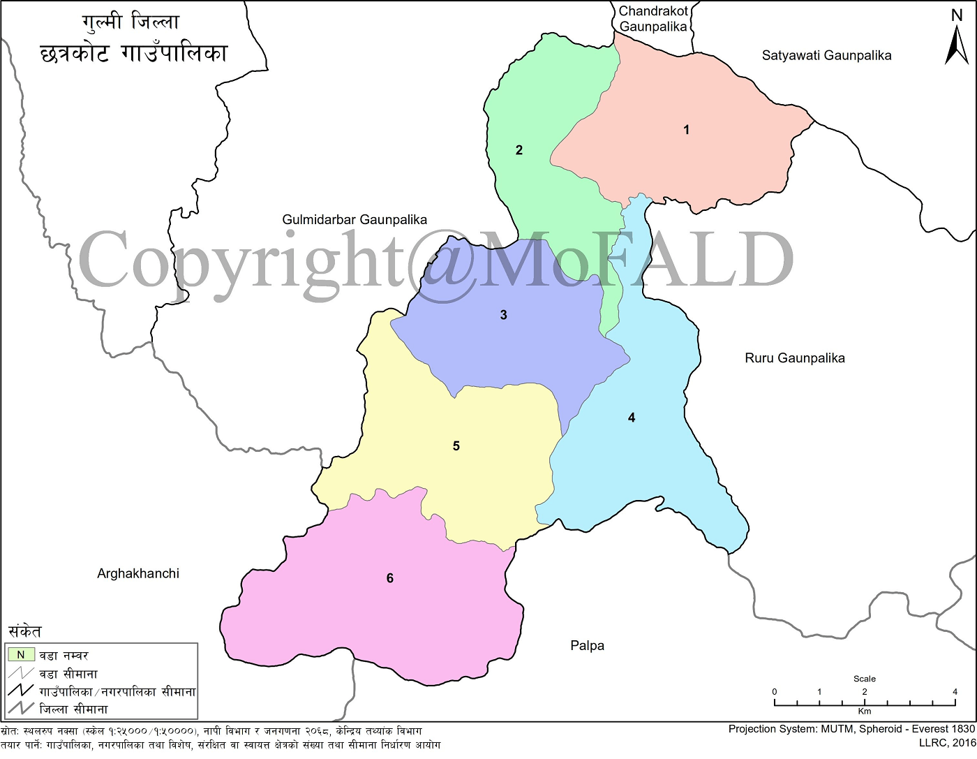
Each of the six wards in Chhatrakot has its own historical, religious, cultural, and archaeological value. Notable sites include:
-
Chhatrakot Devalaya
-
Deauti Durga Shiv Mandir of Hunga
-
Kot Danda in Pallikot (the highest point in the municipality)
-
Kalika Temple of Digam
-
Mankot (Manyakot) of Kharjyang
-
Manbhak Pauwa
-
Bhagwati Temple of Hardineta
-
Ranipokhari of Bhalupani and Dharampani
-
Kahulegadhi, Baraha Temple, Thulo Pokhara, and Alam Temple of Daungha
In Ward No. 4, the large rainwater pond in Shringaa, with a capacity of 900,000 liters, is one of the largest rain-harvesting tanks in Asia.
Natural and Tourism Highlights
The surrounding region offers several tourist attractions, including:
-
Ghalam Maulopokhara area in Digam
-
Two large ponds in Daungha
-
Scenic areas in Hunga, Pallikot, Hardineta, and Kharjyang
With further research and preservation, these sites can develop into significant tourist destinations.
Demographics and Ethnic Diversity
Chhatrakot is home to a diverse population with multi-ethnic, multi-religious, and multicultural communities. Residents include Brahmins, Chhetris, Magars, Newars, Dalits, and minority groups such as Kumals, Botes, Majhis, and Muslims.
Education
There are 49 schools in the municipality—44 community and 3 institutional schools. Among them:
-
10 are secondary schools (9 community, 1 institutional)
-
39 are basic level schools
There are 44 Early Childhood Development Centers—42 school-based and 2 community-based—along with 4 community learning centers.
Location and Area
-
East: Ruru Rural Municipality
-
West: Gulmi Durbar Rural Municipality
-
North: Satyawati and Chandrakot Rural Municipalities
-
South: Chhatradev Rural Municipality (Arghakhanchi) and Rainadevi Rural Municipality (Palpa)
Chhatrakot spans 87.1 square kilometers, with a population of 19,357 (as per the 2021 Census). Elevation ranges from 579 meters (Manbhak, Kharjyang) to 1,676 meters (Kot Danda, Pallikot). The administrative office is located at Choyga, Ward No. 3, at an altitude of 1,555 meters (Latitude: 28.0065° N, Longitude: 83.34603° E).
Administrative Divisions
Chhatrakot Rural Municipality consists of the following wards:
-
Hunga (Wards 1–9)
-
Pallikot (Wards 1–9)
-
Hardineta (Wards 1–9)
-
Digam (Wards 1–9)
-
Kharjyang (Wards 1–9)
-
Daungha (Wards 1–9)
-
Total Wards: 6
-
Center: Choyga, Ward No. 3, Hardineta
Geography and Climate
Chhatrakot is situated in a geographically diverse area, with elevations ranging from 571 to 1,676 meters above sea level. This variation influences its climate, which ranges from subtropical in lower areas to temperate in higher hills. The weather typically includes:
-
Hot Season: March to October
-
Cold Season: November to February
-
Coldest Month: December
-
Warmest Month: May
-
Annual Rainfall: 2,200 mm
-
Average Annual Temperature: 27°C
-
Temperature Range: 5°C to 33°C
During winter, fog usually appears only in the early morning. In summer, slight heat is experienced in lower elevations.
Terrain and Biodiversity
The municipality features a varied terrain, characterized by ridges, slopes, and valleys. Its biodiverse landscape supports a variety of flora and fauna. Climate conditions differ by elevation and season—lowlands are warm, hills are temperate, and higher areas experience mild cold.
Education Status
Education is a cornerstone of human development. As societal needs change, so does the education system. Chhatrakot recognizes the need for updated educational practices and strategic growth in the education sector. Accurate literacy data helps shape effective policies to improve infrastructure and academic outcomes.
Schools in Chhatrakot Rural Municipality
Summary Statistics
-
Pre-school: 36
-
Basic Level Schools: 36
-
Secondary Schools: 10
-
Plus-2 Level Schools: 5
-
Public Schools: 41
-
Private Schools: 2
-
Model School: 1
-
Total Schools: 43
1. Institutional (Private) Schools
-
Chhatradevi Evergreen English Boarding School – Nursery to 10, Chhatrakot, Gulmi
-
Riverside Academy English Boarding School – Nursery to 5, Chhatrakot, Gulmi
2. Secondary Schools (Class 1–12) – National Examinations Board
-
Adarsha Secondary School – Digamkot, Chhatrakot, Gulmi
-
Shree Jana Jagriti Secondary School – Hunga, Chhatrakot, Gulmi
-
Shringa Janata Secondary School – Digam, Chhatrakot, Gulmi
-
Atmabodh Secondary School – Kharjyang, Chhatrakot, Gulmi
-
Main Danda Secondary School – Hardineta Dharampani, Chhatrakot, Gulmi
3. Basic Schools (Nursery to Class 10)
-
Jana Jyoti Secondary School – Nursery to 10, Chhatrakot, Gulmi
-
Nepal Rastriya Secondary School – Nursery to 10, Chhatrakot, Gulmi
-
Saraswati Secondary School – Nursery to 10, Chhatrakot, Gulmi
-
Jana Secondary School – Nursery to 10, Chhatrakot, Gulmi
4. Lower Basic Schools (Nursery to Class 8 or Below)
-
Chandi Devi Basic School – Nursery to 8
-
Adarsha Basic School – Nursery to 8
-
Saraswati Boha Basic School – Nursery to 8
-
Jherdi Basic School – Nursery to 8
-
Daungha Hari Basic School – Nursery to 5
-
Laxmi Basic School – Nursery to 5
-
Jyoti Basic School – Nursery to 4
-
BP Smriti Basic School – Nursery to 3
-
Devisthan Basic School – Nursery to 3 (Listed Twice)
-
Krishna Basic School – Nursery to 3
-
Saraswati Basic School – Nursery to 3
-
Buddhi Binod Basic School – Nursery to 2
-
Jana Sikshya Basic School – Nursery to 2
-
Pipal Danda Basic School – Nursery to 2
-
Pragati Basic School – Nursery to 2
-
Alam Basic School – Nursery to 2
-
Jana Jyoti Basic School – Nursery to 1
-
Kaule Basic School – Nursery to 1
-
Pipal Pokhara Basic School – Nursery to 1
-
Bhagawati Basic School – Nursery to 1 (Listed Twice)
-
Kalika Basic School – Nursery level
-
Janata Basic School – Nursery level
-
Jana Chetana Basic School – Class 2 to 3
-
Bhanu Basic School – Nursery level
Location: All schools listed above are located within Chhatrakot Rural Municipality, Gulmi.
5. Early Childhood Development and Balbikash Centers
-
Janata Bal Bikash Kendra – Nursery level
-
Saraswati Balbikas Kendra – Nursery level
-
Jana Jagriti Balbikas Kendra – Nursery level
-
Bal Jyoti Bal Bikas Kendra – Nursery level
-
Saraswati Balbikash Kendra – 1 to 1
Note: These centers focus exclusively on foundational early childhood learning.

.jpg)


