


Overview
Malika Rural Municipality, Gulmi (Gaupalika - मालिका गाउँपालिका, गुल्मी) is named after the historic and religious Malika Temple, located in a naturally rich region with high tourism potential. Situated approximately 40 km north of the Gulmi district headquarters, Tamghas, the rural municipality can be entered after traveling about 20 km from the district center.
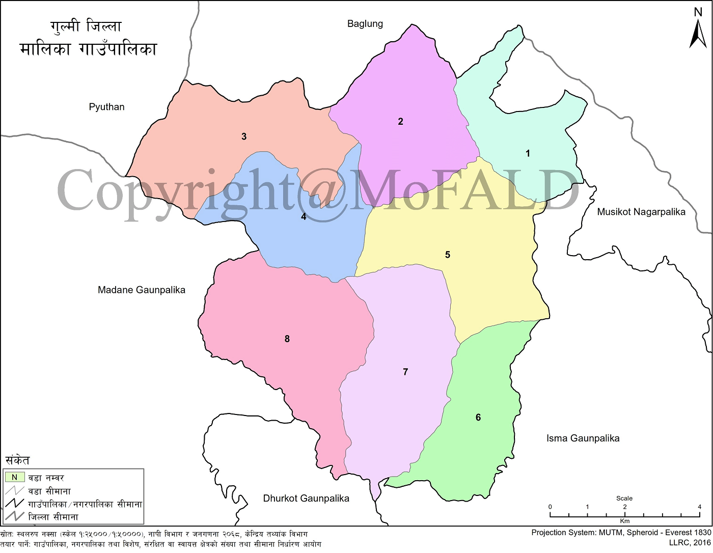
Among the 12 local units in Gulmi district, Malika Rural Municipality has 5,241 households and a total population of 20,075—comprising 10,887 females and 9,188 males. The municipality consists of former Village Development Committees (VDCs): Neta, Darling, Hwangdi, Arkhawang, Chhapahile, Arje, Ghamir, and Marbung.
Geographic Location, Boundaries, and Area
Area
-
92.49 square kilometers
Boundaries
-
East: Isma Rural Municipality
-
West: Madane Rural Municipality
-
North: Baglung District
-
South: Madane Rural Municipality
Rivers, Religious and Tourist Sites
Malika is well known for its religious and tourist attractions, including:
-
Malika Temple
-
Lekpokhara
-
Tike Chuli
-
Major rivers and streams: Chhaldi, Nisti, and Badighat
Location and Coordinates
Located in the northwest of Gulmi within Lumbini Province, Malika borders Baglung District and lies at 28.22° N latitude and 83.13° E longitude. It is about 35 km from Tamghas. The municipality spans 92.49 sq. km.
According to the 2074 BS survey, Malika has a total population of 20,229. The rural municipality comprises 8 wards with its administrative center at Arkhawang. The structure of the former and current wards is as follows:
-
Neta: Old Ward 5–9 → Current Ward 1
-
Darling: Old Ward 1–9 → Current Ward 2
-
Hwangdi: Old Ward 1–9 → Current Ward 3
-
Arkhawang: Old Ward 1–9 → Current Ward 4
-
Chhapahile: Old Ward 1–9 → Current Ward 5
-
Arje: Old Ward 1–9 → Current Ward 6
-
Ghamir: Old Ward 1–9 → Current Ward 7
-
Marbung: Old Ward 1–9 → Current Ward 8
Historical Identity and Naming
Malika exhibits notable religious tolerance, with Hinduism being the dominant faith. Significant historical and religious landmarks include Chhatra Bhumi, Siddhasthan, Radhakrishna Temple, Jodikuti, and Malika Temple. The name of the municipality originates from the Malika Temple, which holds deep cultural significance.
Political Structure
Malika Rural Municipality was established as part of the federal restructuring outlined in Nepal’s Constitution of 2072 BS. It was formed by merging former VDCs: Neta, Darling, Hwangdi, Arkhawang, Chhapahile, Arje, Ghamir, and Marbung.
Topography and Climate
Malika lies in the northwestern part of Gulmi, with elevations ranging from 1,250 meters to 2,900 meters above sea level. This results in diverse climatic conditions. As a hilly region, Malika experiences a temperate monsoon climate with cold winters and mild summers.
-
Warm period: March to October
-
Cold period: November to February
-
Coldest month: December
-
Warmest month: May
-
Average annual rainfall: 2,200 mm
-
Average annual temperature: 27°C
Natural Resources
Water Sources
The rural municipality is home to small streams and ponds that serve as primary sources of irrigation and drinking water. Key ponds include Tikechuli Pokhara, Jaisi Pokhara, Lek Pokhara, and Kutlagaun Pokhara.
Flora and Medicinal Plants
Malika hosts a rich biodiversity. Medicinal plants found in the northern region include:
-
Harro
-
Barro
-
Amala
-
Timur
-
Sajivan
-
Kurilo
-
Gurjo
-
Bojo
-
Pipla
-
Rittha
-
Bhakur
-
Lapsi
-
Bel
These are mainly used domestically, not commercially.
Fauna
Wildlife in the region includes:
-
Animals: Royal Bengal tiger, leopard, bear, wild boar, mongoose, hare, fox, deer, langur monkey, wild cat
-
Birds: Crow, pigeon, sparrow, kalij, owl, bulbul, myna, parrot, hawk, cuckoo, jureli, pheasant, heron, eagle, vulture, jungle fowl
-
Reptiles and Amphibians: Monitor lizard, snakes, chameleon, mouse lizard, frog
-
Insects: Scorpion, cricket, wild bee, hornet, mole, various other insects
-
Aquatic life: Fish in local streams
Cultural Heritage
The majority of residents follow Hinduism. All identified historical and religious sites are Hindu temples. Cultural landmarks include:
-
Chhatra Bhumi
-
Siddhasthan
-
Radhakrishna Temple
-
Jodikuti
-
Malika Temple
Local festivals involve:
-
Navadurga Kot Puja and animal sacrifice during Dashain
-
Traditional Serai dance in each ward during Ekadashi to Purnima
-
Dance and music during Hartalika Teej
-
Krishna Janmashtami celebrations at temples
Annual fairs include:
-
Gagare Mela on Jestha 20 at the border of Gulmi, Pyuthan, and Baglung
-
Offerings at Malika Temple on Baishakh Purnima and Dashain Purnima
Tourism Development
Malika Rural Municipality holds high tourism potential. It includes:
-
Temples, ponds, and high-altitude landscapes
-
Opportunity for religious and modern tourism activities
-
Identified tourist sites:
Religious Sites
-
Chhatra Bhumi Temple
-
Devi Sthan Temple
-
Siddhasthan Temple
-
Manakamana Temple
-
Two Shiva Temples
-
Tike Chuli Jhankri Dhaan Temple
-
Malika Temple
-
Khadka Kshetra Temple
-
Shivalaya
-
Radha Krishna Temple
-
Ram Temple
-
Jodikuti Temple
-
Namata Temple
-
Thanapati Temple
-
Siddheshwari Temple
Lakes and Ponds
-
Tikechuli Pokhari
-
Jaisi Pokhara
-
Dah
-
Lek Pokhara
-
Kutlagaun Pokhari
Ward-Specific Highlights
-
Ward 8 (Khadka Temple): Ancient weapons, Navadurga worship, and animal offerings during Ashtami and Navami
-
Ward 5 (Hilechhap Tikechuli): Siddha Temple and events during Maghe Sankranti, including cultural shows and sports
-
Ward 2 (Darling): Bhailo performance on Tihar Ekadashi showcasing traditional attire and volleyball tournaments
-
Ward 6 (Arje): Ropain Jatra festival on Krishna Janmashtami
-
Ward 7: Cultural events by national artists, the day after Dashain Purnim,a under the leadership of Bam Bahadur Karki
Schools in Malika Rural Municipality, Gulmi
Malika Rural Municipality has a total of 51 educational institutions, serving students across all levels. Here's the summarized classification:
-
Pre-schools: 44
-
Basic Schools: 46
-
Secondary Schools: 11
-
Plus-2 Level: 5
-
Public Schools: 47
-
Private Schools: 4
-
Model Schools: 1
-
Total Schools: 51
Secondary and Plus-2 Level Schools (Grades 1–12)
-
Devisthan Secondary School – Ghamir, Malika, Gulmi (1–12)
-
Malika Secondary School – Marbhung, Malika, Gulmi (1–12)
-
Arjai Secondary School – Pokharabari, Malika, Gulmi (1–12)
-
Arkhawang Secondary School – Arkhabang, Malika, Gulmi (1–12)
-
Neta Darling Secondary School – Smadaring, Malika, Gulmi (1–12)
Private English Boarding Schools
-
Civil English Boarding School – Malika, Gulmi (Nursery–8)
-
Bhairabkali English Boarding School – Malika, Gulmi (Nursery–5)
-
Kisan Awasiya English Boarding School – Malika, Gulmi (1–6)
-
Siddha English Boarding School – Malika, Gulmi (1–5)
Secondary Schools (Up to Grade 10)
-
Jamal Pokhara Secondary School – Malika, Gulmi (Nursery–10)
-
Devisthan Secondary School – Malika, Gulmi (Nursery–10)
-
Hwangdi Mehale Secondary School – Malika, Gulmi (Nursery–10)
-
Shree Chhapahile Secondary School – Malika, Gulmi (Nursery–10)
-
Chyandanda Secondary School – Malika, Gulmi (Nursery–10)
-
Amar Secondary School – Malika, Gulmi (Nursery–10)
Basic Schools (Nursery to Primary Levels)
-
Siddha Basic School – Malika, Gulmi (Nursery–5)
-
Shree Rani Pokhari Basic School – Malika, Gulmi (Nursery–8)
-
Khadga Basic School – Malika, Gulmi (Nursery–8)
-
Bararukha Basic School – Malika, Gulmi (Nursery–8)
-
Thanapati Basic School – Malika, Gulmi (Nursery–8)
-
Siddhamalika Basic School – Malika, Gulmi (Nursery–8)
-
Tammudanda Basic School – Malika, Gulmi (Nursery–4)
-
Thulichaur Basic School – Malika, Gulmi (Nursery–5)
-
Chhatra Basic School – Malika, Gulmi (Nursery–5)
-
Marandanda Basic School – Malika, Gulmi (Nursery–5)
-
Siddheshwori Basic School – Malika, Gulmi (Nursery–5)
-
Kalika Basic School – Malika, Gulmi (Nursery–5)
-
Maidane Chaur Basic School – Malika, Gulmi (Nursery–5)
-
Janajagaran Basic School – Malika, Gulmi (Nursery–3)
-
Janajyoti Basic School – Malika, Gulmi (Nursery–3)
-
Bhumeychaur Basic School – Malika, Gulmi (Nursery–2)
-
Raina Devi Basic School – Malika, Gulmi (Nursery–3)
-
Siddha Baba Basic School – Malika, Gulmi (Nursery–3)
-
Deurali Basic School – Malika, Gulmi (Nursery–2)
-
Bidya Devi Primary School – Malika, Gulmi (Nursery–2)
-
Gaenli Chaur Basic School – Malika, Gulmi (Nursery–2)
-
Paiyapata Basic School – Malika, Gulmi (Nursery–3)
-
Suryodaya Basic School – Malika, Gulmi (Nursery–3)
-
Malika Basic School Okharbot – Malika, Gulmi (Nursery–2)
-
Fulbari Basic Primary School – Malika, Gulmi (Nursery–2)
-
Tikhechuli Basic School – Malika, Gulmi (Nursery–2)
-
Pata Kharka Basic School – Malika, Gulmi (Nursery–2)
-
Malika Basic School – Malika, Gulmi (Nursery–2)
-
Bhagawati Basic School – Malika, Gulmi (Nursery–1)
-
Janasewa Basic School – Malika, Gulmi (Nursery–1)
-
Mulabari Basic School – Malika, Gulmi (Nursery–1)
Early Childhood Development Centers (ECDs)
-
Shantasamaj Balbikas Kendra – Malika, Gulmi (Nursery–Nursery)
-
Banskhola Balbikas Kendra – Malika, Gulmi (Nursery–Nursery)
-
Mirmire Basic School – Malika, Gulmi (Nursery–Nursery)
-
Thadhunga Chisapani Balbikas Kendra – Malika, Gulmi (Nursery–Nursery)
-
Shiva Balbikas Kendra – Malika, Gulmi (Nursery–Nursery)

.jpg)


