


Overview
Deumai Municipality, Ilam - A few decades ago, besides Ilam Bazaar as the district headquarters, Phiikkal in the east and Manglabare in the west were the main trade centers of Ilam. Trade also took place between Manglabare and its neighboring districts of Panchthar and Jhapa.
Previously, the market used to operate every Wednesday in the area known today as “Lower Budhabare” located in Ward No. 4. As the area was far for many traders, they would arrive by Tuesday evening carrying their goods. This led to a bustling scene on Tuesday evenings, resembling a market. It is believed this practice gave rise to the name “Manglabare,” meaning Tuesday-based.
The Wednesday market at Budhabare was considered one of the largest in Ilam. Due to space limitations in Lower Budhabare, around 2015/16 BS, the then Ilam Bada Hakim (chief administrator) Santabir Lama relocated the market to the Manglabare ridge. The tradition of holding the market on Wednesday, however, continued and still exists.
During the Panchayat era, Manglabare was established as a village panchayat. After the restoration of democracy, it became a Village Development Committee (VDC). In 2071 BS, under a cabinet decision, the government merged the then Manglabare and Dhuseni VDCs to form Deumai Municipality among 61 newly declared municipalities.
Later, in line with Nepal's 2072 Constitution and the restructuring process, the existing Deumai Municipality was expanded by merging surrounding VDCs—Chamaitha, Sangrumba, Shantidanda, Siddhithumka, and Jitpur—into the municipality.
The municipality is named after the Deumai River, which flows along its western boundary. The river holds significant religious value in the area.
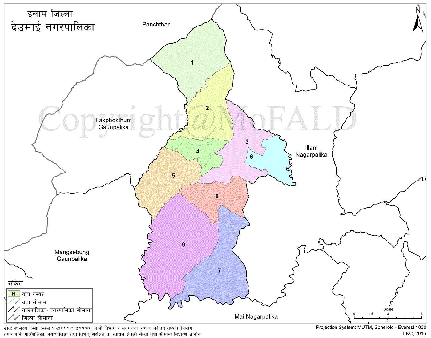
Geographical Location and Area
Deumai Municipality lies in Ilam District of Province No. 1. It is located between 26.816413° to 27.044757° North latitude and 87.7448940° to 88.889877° East longitude.
-
Total area: 191.63 square kilometers
-
Elevation: Ranges from 250 meters to 2700 meters above sea level
-
Covers 0.1302% of Nepal’s land and 11.22% of Ilam District
Borders
-
East: Ilam Municipality
-
West: Fakfokthum and Mangsebung Rural Municipalities
-
North: Panchthar District
-
South: Mai Municipality
Geographical and Climatic Characteristics
-
Located in northwestern Ilam, a trade hub known for cash crops like ginger, cardamom, broom grass, Akabare chili, and tea
-
Recognized for both domestic and international tourism
Latitude
26.816413° to 27.044757°
Longitude
87.7448940° to 88.889877°
Elevation
252 to 2691 meters above sea level
Area
191.63 square kilometers
Boundaries
-
East: Ilam Municipality
-
West: Fakfokthum and Mangsebung
-
North: Panchthar
-
South: Mai Municipality
Climate
The municipality experiences three types of climates based on altitude:
-
Warm monsoon
-
Mild temperate
-
Cold temperate
Shravan is the hottest month, while Poush is the coldest.
Average summer temperature: 16°C to 23°C
Average winter temperature: 4°C to 11°C
Average monthly rainfall during monsoon: 35 cm (350 mm)
Demographics and Services
Household Count
7,124 households
Total Population
34,699
Main Occupations
Agriculture and Animal Husbandry
Number of Schools
59 total schools:
-
45 government
-
14 private
-
1 Gurukul
Student–Teacher Ratio
12:1
Student–Classroom Ratio
13:1
Literacy Rate
88.80%
Major Religions
Hindu
Primary Language
Nepali
Major Communities
-
Rai
-
Brahmin
-
Chhetri
-
Limbu
Major Food Crops
-
Paddy
-
Maize
-
Wheat
Major Cash Crops
-
Ginger
-
Broom grass (Amriso)
-
Tea
-
Cardamom
-
Potato
Common Livestock
-
Cattle
-
Buffalo
-
Goat
Transportation Facilities
-
Bus
-
Taxi
-
Tempo
-
Private vehicles (car, motorcycle)
Communication Services
-
Mobile phone
-
CDMA phone
-
Cable television
-
Internet access
Health Services
-
6 health posts
-
1 primary health center
-
2 private clinics
-
1 Ayurvedic hospital
Electricity Access
91.31% of households have access to electricity
Community Forest User Groups
26 registered groups
Major Settlements by Ward
Ward No. 1
-
Chamaita, Maidane, Rankey, Barbote, Sisne, Sepeni, Yakule Gaun, Kafle Gaun, Chauri Bazar, Tar Gaun, Deurali
-
Dhapatar, Deumi, Kukhure, Dungmali Gaun, Barbhanjyang, Simghre Gaun, Sadhu Gaun, Bahun Gaun, Arje Gaun, Khatri Gaun, Khandrug, Besighare, Cheughare, Muldanda, Mangsire, Deusedanda, Lambagaun, Bhirgaun, Gurung Gaun, Gurunge Gaun (Maidane), Targhare, Khatri Gaun (Maidane), Lalla Gaun, Pandey Gaun, Bhir Gaun (Barbote)
Ward No. 2
-
Pungpung, Sabjung, Tapewa, Baghshila, Chitre, Mahabir, Bhadure, Saune, Naulegaun, Purkhe, Gumbadanda
-
Skuldanda, Sansaridanda, Dulal Gaun, Limbu Gaun, Newar Gaun, Rai Gaun, Sunuwar Gaun, Rana Gaun, Magar Gaun, Gairigaun, Chamlagai Gaun, Devisthan, Jhu
Ward No. 3
-
Shantidanda, Gagrebhanjyang, Surke, Panitar, Pahirebhanjyang, Moolkharka, Dandagaun, Asare Gahari, Rankeytar, Hatedhunga, Lekhtol, Kaparabote
Ward No. 4
-
Yakshi, Majhuwa, Singlappa, Manglabare Bazar, Gurudhara, Tallo Budhabare, Sorali Gaun, Chitre, Bhojpure Tol, Namasing Gaun, Gairigaun
Ward No. 5
-
Bohoribote, Angdanda, Kharbari Gaun, Chiduwa, Hangsebun, Dandagaun, Barbhanjyang, Barung, Dhuseni, Kyabung, Singla
Ward No. 6
-
Chhetri Gaun, Dahal Gaun, Gairigaun, Sisuwa, Dandagaun, Bijuli Bhanjyang, Futuk, Wathung, Skuldanda, Goredanda
Ward No. 7
-
Namthala, Tegiya, Pankhelung, Basthal, Hangmang, Siureni, Makthumba, Panchami, Bhir Gaun, Phulbari, Gairigaun, Chuli Gaun, Guragai Gaun, Siddhithumka, Gorkhe Gaun, Rana Gaun
Ward No. 8
-
Futanichowk, Gairigaun, Buddha Chowk, Talkharka, Lumde, Baseni, Raygaun, Ajambare, Jhyaulpokhari, Kiklumba
Ward No. 9
-
Lingding, Marshe, Nawami, Madibung, Parigaun, Chisapani, Siruwani, Iweg, Bardamba, Jaubari, Dandagaun
Geographical Features
Deumai Municipality lies in the hilly region, predominantly shaped by the Mahabharat Range. More than 15 small and large rivers pass through the municipality.
Soil composition includes:
-
Loamy gravel and stony mixtures
-
Clay-loamy types
-
Compact loamy textures
Major Crops Grown:
-
Paddy, maize, wheat, millet, potatoes, and vegetables
-
Evergreen and seasonal fruits
-
Ginger, cardamom, tea, and coffee
Weather Conditions
Ranging from 252 to 2691 meters in elevation, Deumai Municipality features three climate types:
-
Warm monsoon
-
Mild temperate
-
Cold temperate
Hottest month: Shrawan
Coldest month: Poush
Average Temperatures:
-
Summer: 16°C to 23°C
-
Winter: 4°C to 11°C
Rainfall:
-
During monsoon season, average monthly rainfall reaches 35 cm (350 mm)
-
The climate is favorable for cash crops such as ginger, cardamom, broom grass, and tea
Local Festivals, Fairs, and Celebrations
Deumai is home to a culturally diverse population representing Hindu, Kirat, Buddhist, and Christian communities. Due to migration from different regions across Nepal, the area celebrates a wide variety of festivals.
Major Local Festivals Celebrated in Deumai Municipality
-
Mother’s Day (Tirtha Aunsi)
Celebrated in Baisakh on Aunsi by Hindus and others to honor mothers. -
Buddha Purnima (Buddha Jayanti)
Observed in Baisakh on Purnima by Buddhist and mixed communities. -
Asar 15 – Dahi Chiura Festival
Celebrated in Asar across all farming communities to mark the start of rice planting season. -
Luto Falne Jatra
Traditionally observed around Shrawan Sankranti; now rarely celebrated. -
Harishayani Ekadashi (Tulsi Plantation)
Celebrated in Shrawan on Ekadashi by Hindu devotees. -
Guru Purnima
Celebrated in Shrawan on Purnima as Teacher’s Day in schools. -
Nag Panchami
Observed in Shrawan–Bhadau on Panchami by Brahmin, Chhetri, and Hindu communities. -
Janai Purnima
Celebrated in Shrawan–Bhadau on Purnima by Brahmins and other Hindus. -
Kwati Eating Day
Observed on Janai Purnima, particularly by Newar and Kirati communities. -
Last Monday of Shrawan
Celebrated mostly by Hindu women through fasting and rituals. -
Gai Jatra
Observed in Bhadau, especially by Newar communities to honor the deceased. -
Krishna Janmashtami
Celebrated in Bhadau by Hindus to mark the birth of Lord Krishna. -
Haritalika Teej
Celebrated by Hindu women in Bhadau through fasting and prayers. -
Vishwakarma Puja
Observed in Ashoj by Hindu artisans, mechanics, and workers. -
Dashain (Ghatasthapana to Kojagrat Purnima)
Celebrated in Ashoj–Kartik across all Hindu communities. -
Tihar (Kag, Kukur, Laxmi, Govardhan, Bhai Tika)
Observed in Ashoj–Kartik by all Hindu communities. -
Mha Puja
Celebrated in Kartik by Newars to purify and honor the self. -
Chhath Parva
Observed in Kartik, especially by women from Madhesi communities. -
Tamu Lhosar
Celebrated in Poush by Gurung and Tamang communities. -
Tol Lhosar
Celebrated in Poush by Gurung, Tamang, and Rai communities. -
Sonam Lhosar
Celebrated in Magh by Gurung, Tamang, and Rai ethnic groups. -
Maghe Sankranti
Celebrated on Magh 1 by all communities to mark the end of winter. -
Gyalmo Lhosar
Celebrated in Falgun–Chaitra by Tibetan Buddhist communities. -
Holi (Fagu Purnima)
Celebrated in Falgun on Purnima across all communities in the hills and plains. -
Maha Shivaratri
Celebrated in Falgun by Hindu devotees in temples and shrines. -
Ram Navami
Celebrated in Chaitra by Hindus to honor the birth of Lord Ram. -
Chaite Dashain
Celebrated in Chaitra by Hindu communities with rituals similar to Dashain. -
Bakra Eid
Celebrated by Muslim communities with special prayers and offerings. -
Christmas
Celebrated in Poush by Christians and mixed communities. -
Udhauli (Sakela, Chasok, Tangnam)
Celebrated in Mangsir on Purnima by Rai, Limbu, Sunuwar, and Yakkha communities.
Major Tourist Attractions in Deumai Municipality
-
Kuibhir (Chamaita Ward 6)
-
Ideal for rock climbing
-
Various species of rhododendron are found
-
Panoramic sunrise views
-
The known habitat of the red panda
-
-
Khambudanda (Chamaita Ward 6)
-
Picnic spot
-
Site for Sakewa festival
-
Traditional place for Sansari Puja
-
Religious significance
-
-
Bhavabhara Danda (Chamaita Ward 1 & 2)
-
Offers scenic views of Kanchanjunga and Kumbhakarna peaks
-
-
Deumai–Hewa Confluence Hill (Chamaita Ward 5)
-
Located at the junction of Deumai and Hewa rivers
-
Geographically and culturally important
-
-
Ratna Tunnel (Chamaita Ward 7)
-
Historically important
-
Politically significant site
-
-
Guphathumki Hill (Chamaita Ward 7)
-
Scenic viewpoint
-
Wildlife viewing possible due to nearby community forest
-
-
Soharana Devi Temple (Chamaita Ward 7)
-
Religious tourism site
-
-
Tall Rhododendron Tree (Manglabare Ward 3)
-
Recorded in Guinness Book of World Records
-
Globally recognized natural attraction
-
-
Hanglung Waterfall (Chamaita Ward 8)
-
Visually stunning waterfall
-
-
F Community Forest and Pokhari (Shantidanda Ward 7)
-
Sunrise viewpoint
-
Scenic beauty of Gufa Pokhari
-
Around 80 tourists visit daily
-
Popular picnic spot
-
-
Panitar (Manglabare Ward 4)
-
Rolling hills covered with tea plantations
-
-
Dhode Devi (Manglabare Ward 4)
-
Naturally formed divine stone sculptures
-
Offers wide panoramic views of Ilam
-
Visited by 200+ tourists daily
-
Popular for daily Hindu worship
-
-
Dhodrebar Tree (Manglabare Ward 2)
-
Estimated 400-year-old sacred tree
-
-
Kabrawat Tree (Shantidanda Ward 5)
-
Massive Kabra tree over 300 years old
-
50-foot hollow base allows people to walk through
-
Weekly Tuesday worship tradition
-
Name origin of Manglabare believed to stem from here
-
-
Thulo Nagi (Manglabare Ward 6)
-
Picnic site and observation point
-
-
Nilkantha Mahadev Temple (Manglabare Ward 6)
-
Known for spiritual healing practices
-
-
Devdanda (Manglabare Ward 1)
-
Hindu religious and scenic site
-
-
Chamere Cave (Dhuseni Ward 3)
-
20 feet deep cave by the riverbank
-
Known for large bat populations
-
Lacks promotion and protection
-
-
Jatteshwor Mahadev Temple (Dhuseni Ward 2)
-
Naturally formed idols of Hindu deities
-
-
Nageshwari (Dhuseni Ward 7)
-
Believed to be spiritually powerful
-
Popular for tantric healing and prophecy
-
Site of legendary folklore involving Limbu shamans
-
-
Jogi Cave (Dhuseni Ward 2)
-
Believed to be an ancient meditation site
-
Historically significant
-
Gorkhali army used it during unification battles
-
-
Chhala Wal Danda (Dhuseni Ward 7)
-
Natural hot spring pond
-
Thought to cure skin diseases
-
Popular viewpoint and picnic area
-
-
Luti Mai Pokhari (Shantidanda Ward 9)
-
Sacred pond associated with Luti goddess
-
Religious rituals conducted annually
-
-
Ajambare Hill (Siddhithumka Ward 5)
-
Site for various cultural and religious ceremonies
-
-
Ratna Cave (Siddhithumka Ward 7)
-
Holds political significance
-
Rock formations with unique shapes
-
-
Siddhithumka Peak (Siddhithumka Ward 3)
-
Sunrise viewpoint
-
Home to a large worship stone
-
Devi temple present
-
Rare Hi-Guwa plant found
-
-
Pankhelung Waterfall (Siddhithumka Ward 7)
-
Approx. 100-foot tall double-tiered waterfall
-
-
Jhyaun Pokhari (Jitpur Ward 2)
-
Surrounded by water and a central mound
-
Picturesque natural pond
-
-
Dattatreya Temple (Jitpur Ward 2)
-
Estimated to be 150 years old
-
Hindu religious pilgrimage site
-
-
Lechumba Hill (Jitpur Ward 6)
-
Elevated hilltop
-
Offers views of the Terai plains
-
Site of Mahaguru Falgunanda’s meditation
-
Revered by followers of the Kirat religion
-
Educational Institutions in Deumai Municipality
Community Schools in Deumai Municipality
-
Shree Kanchanjungha Basic School – Ward 1, Muldanda, established 2050
-
Shree Dambaradevi Secondary School – Ward 1, Chauri Gaun, established 2013
-
Shree Janata Basic School – Ward 1, Khandrug, established 2047
-
Shree Kamaladevi Basic School – Ward 1, Maidane, established 2021
-
Shree Singhbasanta Basic School – Ward 1, Maidane, established 2048
-
Shree Janata Basic School – Ward 1, Barbote, established 2056
-
Shree Siddha Deumai Basic School – Ward 1, Dhappar Tar, established 2033
-
Shree Singhadevi Basic School – Ward 2, Mahabir, established 2059
-
Shree Bhanudaya Basic School – Ward 2, Pungpung, established 2026
-
Baghshila Basic School – Ward 2, Baghla, established 2054
-
Saujung Basic School – Ward 2, Saujung, established 2016
-
Devisthan Basic School – Ward 2, Saujung, established 2066
-
Saraswati Basic School – Ward 2, Tapewa, established 2031
-
Sahabeer Basic School – Ward 3, Moolkharka, established 2021
-
Shree Singhadevi Basic School – Ward 3, Dhung, established 2034
-
Shree Panch Secondary School – Ward 3, Shantidanda, established 2012
-
Shree Sarke Basic School – Ward 3, Sarke, established 2046
-
Mahendrodaya Basic School – Ward 3, Gagre Bhanjyang, established 2012
-
Jub Basic School – Ward 3, Ranketar, established 2064
-
Janasram Basic School – Ward 4, Singlappa, established 2048
-
Bhanubhakta Secondary School – Ward 4, Manglabare, established 2008
-
Netrajyoti Basic School – Ward 4, Yakshi, established 2052
-
Laxmi Basic School – Ward 5, Kyabung, established 2025
-
Janakalyan Basic School – Ward 5, Angdang, established 2026
-
Savitridevi Basic School – Ward 5, Angdang, established 2047
-
Shree Rudra Basic School – Ward 5, Singlappa, established 2033
-
Shree Kalika Basic School – Ward 5, Singlappa, established 2033
-
Bhagwati Secondary School – Ward 5, Barbhanjyang
-
Nageshwari Basic School – Ward 5, Barung
-
Shree Singhadevi Basic School – Ward 6, Futuk, established 2040
-
Shree Khandrug Secondary School – Ward 7, Panchami, established 2013
-
Shree Gambhir Pokhari Basic School – Ward 7, Pokhari Gaun, established 2043
-
Shree Adarsha Siddha Basic School – Ward 7, Namthala, established 2017
-
Shree Kankai Basic School – Ward 7, Basthal, established 2054
-
Shree Gorkhe Basic School – Ward 7, Gorkhe Gaun, established 2055
-
Shree Janata Basic School – Ward 8, Talkharka, established 2026
-
Janakalyan Basic School – Ward 8, Ambote, established 2055
-
Bhagwati Basic School – Ward 8, Ambote, established 2018
-
Deurali Basic School – Ward 8, Deurali, established 2031
-
Shree Tribhuvan Basic School – Ward 9, Lingding, established 2025
-
Shree Deumai Subidar Bhanjyang Basic School – Ward 9, Subidar Bhanjyang, established 2045
-
Shree Gajurmukhi Basic School – Ward 9, Majh Gaun, established 2044
-
Jitpur Secondary School – Ward 9, Nawami, established 2013
-
Shree Singhwahini Basic School – Ward 9, Katahara, established 2051
-
Shiddhadevi Saraswati Basic School – Ward 9, Jitpur, established 2049
Institutional (Private) Schools in Deumai Municipality
-
Chamaita English Institute – Ward 1, Chauri Gaun, established 2051
-
Bhavabhara Bokul Secondary School – Ward 1, Maidane, established 2047
-
Suryodaya Shiksha Sadan Secondary School – Ward 1, Manglabare, established 2050
-
Gajurmukhi Vidya Mandir – Ward 3, Shantidanda, established 2070
-
Himalayan Secondary School – Ward 3, Shantidanda, established 2045
-
Ilam Morning Glory Secondary School – Ward 4, Chitre, established 2065
-
Sirjansheel Secondary School – Ward 4, Yakshi, established 2057
-
Namuna Boarding School – Ward 5, Dhuseni, established 2066
-
Evangelina E-Boarding School – Ward 6, Futuk, established 2068
-
Shree Panchami E-Boarding School – Ward 7, Panchami, established 2063
-
Ilam Dipshikha Boarding School – Ward 8, Bazaar, established 2060
-
Dattatreya Boarding School – Ward 8, Ambote, established 2058
-
Ex-Army Gorkha Exemplary School – Ward 8, Ambote, established 2050
-
Shree Sayapatri Vidya Mandir – Ward 9, Nawami, established 2056
Gurukul in Deumai Municipality
-
Shree Shivashakti Gurukul – Ward 4, Yakshi, established 2066
Higher Education (College)
-
Manglabare Multiple Campus
-
Ward 4, Manglabare
-
Programs Offered: Education, Humanities, Management
-

.jpg)


