Overview
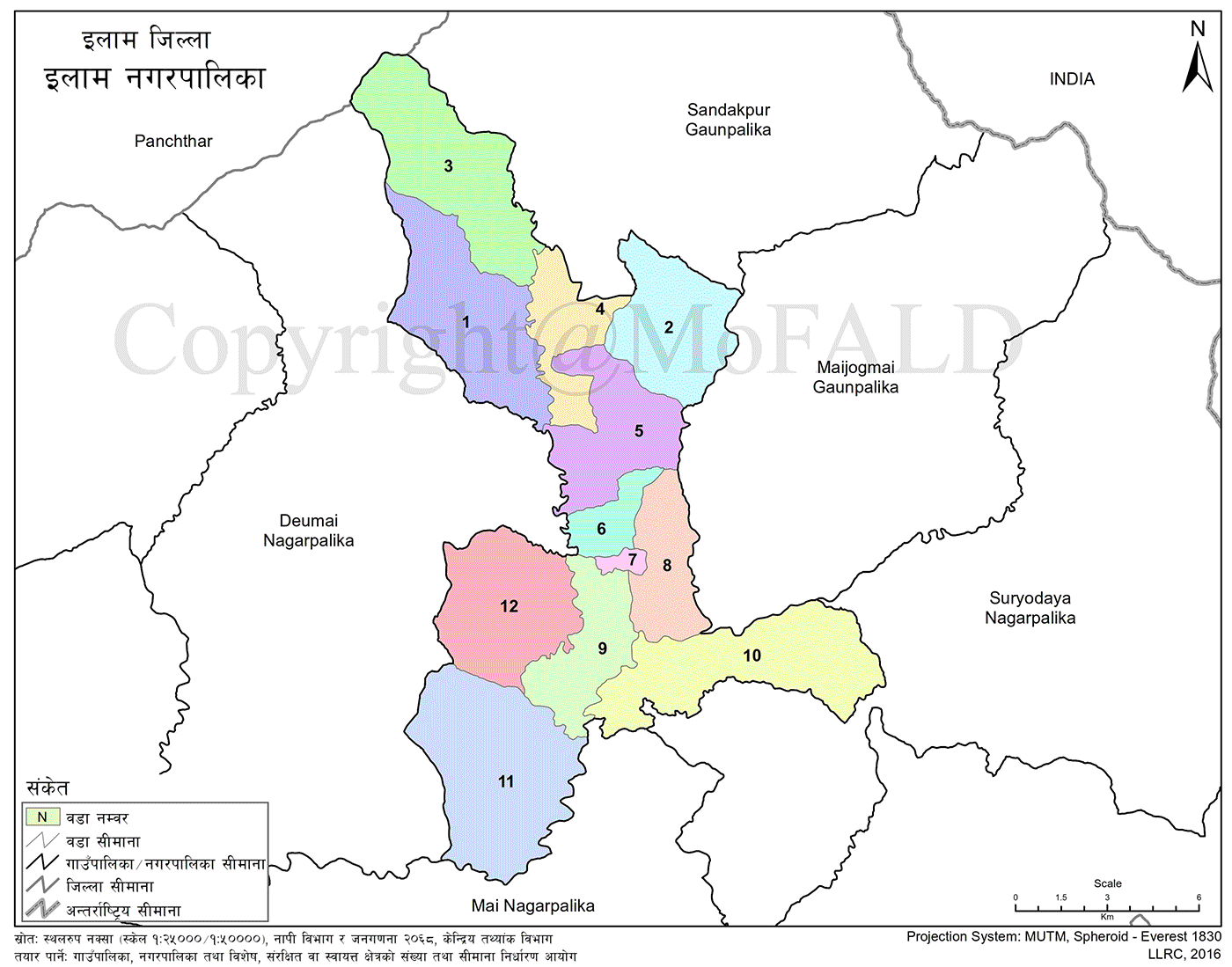
Ilam Municipality is one of Nepal’s oldest municipalities, covering an area of 173.32 square kilometers. It shares its eastern boundary with Maijogmai Rural Municipality and Suryodaya Municipality, the northern boundary with Sandakpur Rural Municipality and Panchthar District, the western boundary with Deumai Municipality, and the southern boundary with Mai and Suryodaya Municipalities.
As the district headquarters for over 200 years, Ilam Municipality shares its name with Ilam District, making it representative of the region for those unfamiliar with local subdivisions.
Socio-cultural and Geographical Diversity
The municipality is known for its geographical diversity, ethnic harmony, and significant cultural and historical heritage. Ilam serves as the central hub for education, health, sports, industry, commerce, and tourism in the district. With a population of 50,085 and a population density of 289 per square kilometer, it plays a vital role in regional development.
Major rivers like Mai, Jogmai, and Puwa flow through this municipality, making it one of the most productive areas for crop cultivation. The population comprises Rai, Limbu, Brahmin, Chhetri, Tamang, Magar, Newar, and other ethnic groups. Institutions like orphanages, senior care homes, schools for children with disabilities, and technical institutes reflect the municipality’s social commitment.
Administrative and Historical Background
Formation and Structure
Located in Province No. 1, Ilam District, this hilly region was established as a district headquarters in 1875 BS. It became a municipality in 2015 BS, a town council in 2019 BS, and was reinstated as a municipality in 2047 BS. Ilam Municipality is currently divided into 12 wards.
Recognized as a developing tourist town, it is even proposed as a potential provincial capital. Infrastructure development—including an airport, biodiversity sites, meeting halls, and academic institutions—is advancing rapidly.
From its inception, Ilam Municipality has served local people by addressing both daily and long-term needs. It aims to lead in improving the social and economic wellbeing of its residents.
Natural Setting and Tourism
Scenic and Strategic Importance
Situated in the eastern hills of Koshi Province, Ilam is a major attraction for tourists. Located between 26.40'–27.80' N latitude and 87.40'–88.10' E longitude, it covers a total area of 1,703 sq. km. The municipality itself spans 173.32 sq. km, with elevations ranging from 200 to 3,000 meters.
Ilam is nestled between the Mahabharat and Singhalila mountain ranges. It is famously known as the “Land of Four Rivers”—Jogmai, Puwa, Mai, and Deumai—all flowing through the area. Favorable weather conditions make Ilam an attractive destination for domestic and international visitors alike.
Demographics and Infrastructure
Previously limited to 28.7 sq. km, the municipality expanded to 173.32 sq. km under the 2072 Constitution of Nepal. Though diverse in geography, it maintains ethnic and social harmony.
The town area is also a key trade center. Connected by the Mechi Highway, Ilam’s physical infrastructure is well-developed. Important landmarks such as the Ilam Airport, Tudikhel ground, Nishan Bhagwati temple, senior citizens’ homes, and a multi-disciplinary college lie within the municipality.
The total number of households is 12,952, with a population of 50,455 and a density of 280 people per square kilometer. The area is fertile due to river valleys like Mai, Jogmai, and Puwa, making it a major agricultural zone. Ilam Tea Factory and major tea gardens are located in Ward No. 7, which also houses the municipal office.
Historical Development and Name Origin
Evolution of Ilam Bazar and Khalkha Center
Ilam Municipality serves as the administrative center of both Ilam District and the Mechi Zone. The urban area spans Wards 6, 7, 8, and 9.
The administrative center was established in 1875 BS as Khalkha. Government offices, residences, and military barracks were built over time. Markets emerged around the "Nishan Danda" and gradually transformed into Ilam Bazaar.
Significant landmarks include:
-
Old Royal Palace (1920)
-
Maisthan Temple (1880s)
-
Bhimsensthan Temple (1909)
-
Narayansthan Temple (1922)
-
Tudikhel Ground (1939)
-
Silkhana Building
Traditional marketplaces like Lakuri Chautara (East) and Pipal Chautara (West) developed in the central junction. Well-planned roads connected major points including Maisthan, Tudikhel, Narayansthan, and the palace.
Nepal’s first tea plantation (1920) was established here, making Ilam Bazaar a planned and scenic market town. By 2007 BS, reforms were introduced by the Eastern Autonomous Government.
In 2015 BS, a market committee was formed under Bada Hakim Santbir Lama to manage trade zones and cleanliness. The committee introduced a printed receipt system for service charges.
The municipality was formally declared in 2016 BS through Nepal’s first elected parliament. In 2019 BS, nine wards were designated. This structure continued until 2073 BS. Under the new constitution, the municipality was restructured into 12 wards.
Administrative Boundaries and Governance
Formation of Modern Ilam Municipality
The municipality now comprises:
-
Entire former Ilam Municipality
-
All areas from 7 former VDCs: Sankhejung, Puwajhuwa, Sumbek, Barbote, Godak, Soyak, and Inpa
-
Wards 1–6 of former Sangrumba VDC
-
Ward 7 of Siddhithumka VDC
-
Wards 1–3 of Maipokhari VDC
Its borders are:
-
East: Maijogmai Rural Municipality and Suryodaya Municipality
-
North: Sandakpur Rural Municipality and Panchthar District
-
West: Deumai Municipality
-
South: Mai and Suryodaya Municipalities
The municipal office is located in Ward No. 7.
Topography
Ilam lies along the Mahabharat mountain range. As a hilly region, its streams flow from north to south into the Mai River. Most areas are flat and suitable for settlements.
Natural Resources
Ilam is rich in natural assets including:
-
Fertile agricultural land
-
Government, community, and private forests
-
Diverse flora and fauna
-
Rivers, ponds, wetlands
-
Mineral resources
Rare and endangered species like the red panda inhabit its northern forests. The district is home to various herbs, birds, butterflies, mammals, amphibians, and aquatic animals.
Main rivers: Mai (East), Puwa (West), along with many tributaries. Due to varied topography and climate, the availability and quality of natural resources differ by region.
Minerals with potential presence:
-
Metallic: Arsenic, Copper, Gold, Lead, Nickel, Silver, Tungsten, Zinc
-
Non-metallic: Corundum, Graphite, Mica, Pyrite, Tourmaline
Cultural Diversity
Ilam hosts a multicultural society with Brahmin, Chhetri, Newar, Sunuwar, Tamang, Rai, Limbu, Madhesi, Marwari, Magar, Gurung, Dalit, and other communities.
Cultural practices are based on ethnic customs, including festivals like:
-
Hindu: Dashain, Tihar
-
Kirat: Sakela
-
Buddhist: Lhosar
-
Seasonal: Udhauli, Ubhaūli
Cultural attire is worn during festivals. Major events include:
-
Gaijatra
-
Rice Plantation Festival
-
Dhan Naach
-
Balan Naach
-
Sakela Naach
Cultural landmarks include:
-
Old Royal Palace (1920)
-
Maisthan Temple (1880s)
-
Bhimsensthan Temple (1909)
-
Narayansthan Temple (1922)
-
Simbahini and Singhdevi Temples
-
Maili Pathibhara
-
Shree Krishna Pranami Temple
-
Setidevi Temple
These sites represent the rich cultural identity of Ilam.
Community Schools Within the Municipality
-
Adarsha Secondary School – Udayapur
-
Saraswati Secondary School – Chulachuli
-
Janata Secondary School – Jitpur
-
Ilam Secondary School – Ilam
-
Mahendra Secondary School – Sumbek
-
Nepal Rastriya Secondary School – Barbote
-
Ganesh Secondary School – Godak
-
Panchakanya Secondary School – Soyak
-
Shree Secondary School – Mangalbare
-
Janapriya Secondary School – Sangrumba
-
Shree Secondary School – Puwamajuwa
-
Bal Kalyan Secondary School – Soyak
-
Shree Secondary School – Gajurmukhi
-
Bhanu Secondary School – Kolbung
-
Ilam Multiple Campus
-
Setidevi Secondary School – Siddithumka
-
Durga Secondary School – Namsaling
-
Gyanodaya Secondary School – Ektappa
-
Pashupati Secondary School – Ektappa
-
Bal Mandir Secondary School – Pashupatinagar
-
Daya Secondary School – Maipokhari
-
Shree Secondary School – Jamuna
-
Himalaya Secondary School – Chamaita
-
Shree Secondary School – Shantipur
-
Shree Secondary School – Gorkhe
-
Shree Secondary School – Godak
-
Devi Secondary School – Kolbung
-
Shree Secondary School – Mangalbare
-
Janajagaran Secondary School – Soyak
-
Buddha Secondary School – Gajurmukhi
-
Bidhya Jyoti Secondary School – Jitpur
-
Gokul Secondary School – Sangrumba
-
Laxmi Secondary School – Fikkal
-
Saraswati Secondary School – Ilam
-
Saraswati Secondary School – Kolbung
-
Siddheshwari Secondary School – Soyak
-
Janashakti Secondary School – Barbote
-
Gyan Jyoti Secondary School – Mangalbare
-
Devi Secondary School – Chisapani
Private and Institutional School Details
-
Little Flower Boarding School
-
Location: Ilam Municipality, Ilam
-
Registration No.: 452
-
Approval Date: 2054/02/05
-
Status: Basic + Secondary (English-medium)
-
-
Summit Academy Boarding School
-
Location: Ilam Municipality, Ilam
-
Registration No.: 392
-
Approval Date: 2053/01/31
-
Status: Basic + Secondary (English-medium)
-
-
Siddhi Vinayak English Secondary School
-
Location: Ilam Municipality Ward No. 7
-
Registration No.: 634
-
Approval Date: 2058/11/30
-
Status: Secondary
-
-
Shree Ram English School
-
Registration No.: 934
-
Approval Date: 2066/02/01
-
Status: Basic Level (Nursery to Grade 8)
-