

Overview
Manthali municipality was established in 2014 as a local government of Nepal. The headquarters of this municipality is located in Manthali, Ramechhap District of Nepal that was established. Manthali, Bhatauli, Chisapani, Kathjor, Maluwajor, Salupati, and Sunarpani former Village Development committees were incorporated to formed this urban municipality.
Manthali municipality (मन्थली नगरपालिका, रामेछाप) is one of the two municipalities in Ramechhap district. Manthali Municipality by the Government of Nepal It was declared as a municipality in 2071 BS and in the local level construction of 2073 BS, Manthali municipality was declared by adding the previous municipality and some former VDCs. Geographical Location Bagmati Pradesh District: Ramechhap Boundary: Ramechhap Municipality in the East, Khandadevi Rural Municipality in the West, Dolakha District and Likhu Tamakoshi Rural Municipality in the North and South Ramechhap Municipality and Sindhuli District.
The area of Manthali Municipality is 211.78 sq. Km. As per the census of 2068 BS, the population is 45416 and the population density is 218.97. There is a story connected with the local fisherman caste regarding the naming of the district headquarters Manthali. From time immemorial, fisher castes have been living in VDCs like Chisapani, Manthali, Bhatauli, Bhaluvajor, and Pakarwas. According to the custom of having a separate king of that caste, there is a king named Mana, and the place where the king resides is called Manthalo.
Ramechhap is a mountainous district in the Bagmati Province of Nepal. Although close to the capital, it is a remote area in terms of service facilities. Kavrepalanchok district, which is touched by the capital, lies between Dolakha and Okhaldhunga districts bordering China and Sindhuli district, which is touched by the Terai. This district of 1546 sq. Km is neglected despite having sufficient resources. Ramechhap is also known as the district of Tinlal.
Subba Krishnalal Adhikari, Martyr Ganga Lal Shrestha, and Founder General of the Communist Party of Nepal Pushpalal Shrestha were born in Ramechhap.
Ramechhap has produced all the talents of Nepali political art, literature, industrialists, businessmen, scholars, cultural workers, and media workers. According to the decentralization regulations of 2056, this district now falls in the category of inaccessible. The geographical extent of the district extends from 27 degrees 28 north latitude to 27 degrees 50 north and from 85 degrees 50 east longitude to 86 degrees 35 east. The topography of Ramechhap district extends from the central Mahabharata mountain range to the high mountain range, from 426 meters above sea level to 6958 meters to Numbur Himal Chuli. This Ramechhap district has been divided into 8 local levels and 2 constituencies with effect from the date of the Government of Nepal.
Ramechhap, which has a history of 210 years from 1836 BS to 2046 BS, sometimes as Gowda Goshwara, sometimes as the base of the Chief Governor, sometimes as a zonal level administrative body and sometimes as a district-level administrative site, has been living in various ways since 2045 BS.
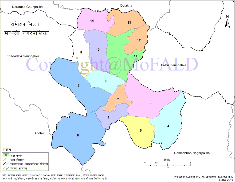
Geographical Map of Manthali Nagarpalika (Municipality):
Contact Address:
Location: Manthali Municipality, Manthali, Ramechhap, Bagmati Pradesh, Nepal
Telephone: +977-48-540532
Email: [email protected]
Website: www.manthalimun.gov.np