


Overview
Kavrepalanchok district is bounded on the east by Ramechhap and Dolakha, on the west by Kathmandu, Lalitpur, and Bhaktapur, on the north by Sindhupalanchok and on the south by Sindhuli and Makwanpur districts. Surrounded by Sunkoshi in the east, Nagarkot Danda and Sanga Bhanjyang in the west, Indravati and Sunkoshi rivers in the north and Kokhajor and Khani rivers in the south, this district is considered to be a district of geographical heterogeneity and natural resources.
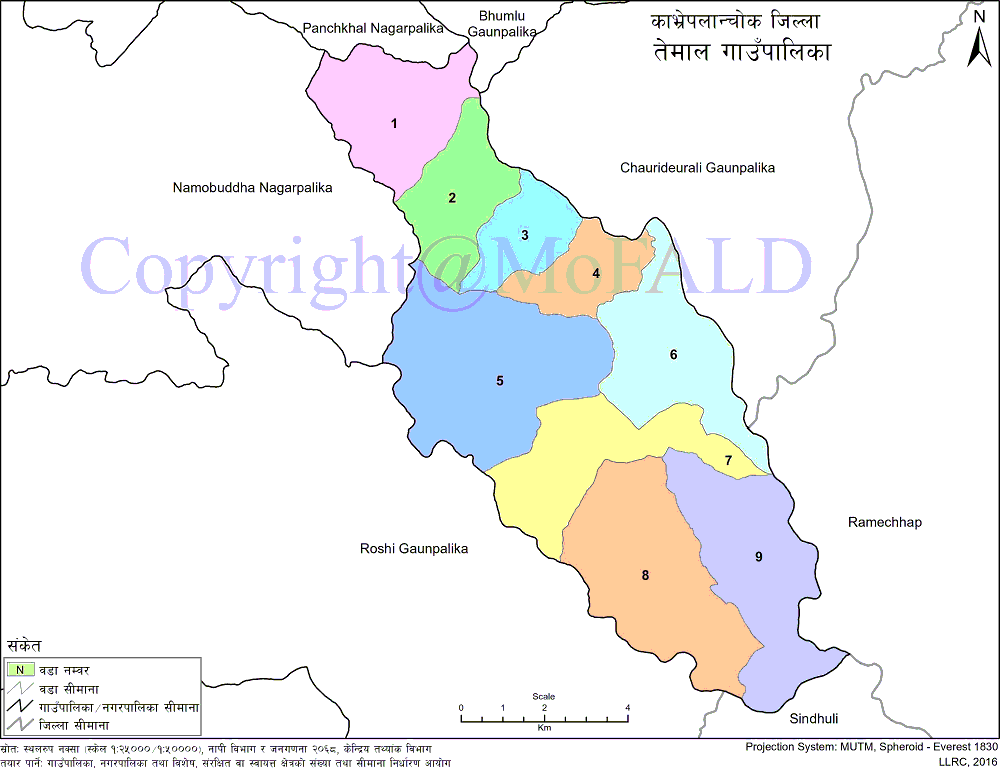
There are 7 rural municipalities and 6 municipalities in this district. The Temal Gaupalika is one of the 7 rural municipalities. The Temal Rural Municipality (तेमाल गाउँपालिका, काभ्रेपलाञ्चोक), which is separate from other rural municipalities of the district, it is 40 km distance from the district headquarters. In the Temal Gaupalika, which is made up of 7 VDCs of the former, Savik Sasryunkharka has been divided into wards 1 and 2. Former Saramathali has been divided into ward no. 3, Boldefediche into ward no. 4, Pokharinarayansthan into ward no. 5, Thuloparsel into ward no. 6, Kuruwas Chapakhori into ward no. Thus, there are currently 9 wards in this Gaupalika.
To the east of Temal are Chauri Deurali and Ramechhap districts, to the west are Roshi and Namobuddha municipalities, to the north are Chauri Deurali, Bhumlu, and Panchkhal municipalities, to the south, are Roshi Gaupalika and Sindhuli districts. The area of this rural municipality is 89 square kilometers and based on the census of 2068 BS, it has a population of 22,712. The historical temple of Narayan at Pokhrinarayansthan of this village, the Buddhist, Swayambhu, and Namobuddha stupas in the same premises, Tongsum Kunda, the temple of Santaneshwar Mahadev at Kuruvas Chapakhori are known as places of abundance in terms of religious tourism. Similarly, Bhim Paila on the banks of Sunkoshi in Ward No. 4 Bolde under Temal Municipality, Gaukhuru in Ward No. 6 Thuloparsel Bhanjyang, are endangered mythological sites which the important responsibility of the municipality is to protect and promote. In addition to this, it is very important to protect and promote the mythological and religious temples and monasteries in various wards under the Temal Gaupalika. From the highlands of Temal, the mountain ranges from Kanchananja to Dhaulagiri can be seen in waves. Kathmandu Valley and Sindhuli fort can also be seen from Temal hill.
The village is heavily populated by Buddhists, including Hindus and Christians. Currently, there is a majority Tamang community in the area, along with Brahmins, Chhetris, Newars, Magars, and Dalits, as well as marginalized tribal fishermen. The people here have been embracing agriculture, animal husbandry, tourism business and cultivation of Bodhi Chittamala, which has religious significance, as their main occupation.
As this rural municipality extends from the banks of Sunkoshi and Roshi to the hills of Temal, there is a problem of drinking water, especially for the people living in the upper part. The products here do not support the living standards of the people. Due to seasonal farming, farmers are not able to benefit much from agribusiness due to drought, excessive rains, intermittent rains, and drought. The challenge of establishing this village municipality as a capable village municipality with a geographically moderate hilly terrain has fallen on the shoulders of the entire villagers and governmental and non-governmental bodies. In order to turn the possibilities here into opportunities and to reduce the problems here, there is a need to work in a planned manner.
Due to this, Temal Rural Municipality has been making initiatives for the overall development of the region and has been making plans and programs every year. Accordingly, an annual policy and program for the Fiscal Year 2074/75 has been prepared with the active participation of newly elected people's representatives, representatives of thematic offices, representatives of non-governmental organizations, civil society and all stakeholders.
Border:
East: Chauri Deurali and Ramechhap districts
In the west: Roshi rural municipality and Namobuddha municipality
Answer: Chauri Deurali Rural Municipality, Bhumlu Rural Municipality, and Panchkhal Municipality
South: Roshi Rural municipality and Sindhuli district
Elevation: 1890 m above sea level
Area: 89 sq. Km.
Length: 10 km on average.
Climate: Temperate (Medium hilly climate)
Center: Former Pokhrinarayanasthan VDC Office of
Geographical Map of Temal Rural Municipality:
Contact Address:
Location: Pokhari Narayansthan, Temal Gaupalika, Kavre, Bagmati Pradesh, Nepal
Telephone: +977-11-691149
Email: [email protected]
Website: www.tmalmun.gov.np