


Why Look Beyond Everest and Annapurna?
Nepal rewards curiosity. Outside the classic circuits, entire valleys run quiet, monasteries watch over wind-scoured passes, and lakes shift from cobalt to teal as clouds move overhead. These places aren’t secret—they’re simply harder to reach, and that’s the point. Traveling where footfall is lighter spreads income, protects fragile trails, and gives you time with the people who keep these landscapes alive.
This guide focuses on less-traveled regions—places where the payoff is cultural depth, intact ecosystems, and a stronger sense of wild. It also anchors planning in facts: current entry rules, conservation designations, and realistic access. Nepal has built an impressive protected-area network—12 national parks, 6 conservation areas, a wildlife and a hunting reserve—now covering 23.39% of the country. That framework matters: it shapes routes, permits, and how travelers can support community-led conservation.
Responsible trekking is now formalized. On most mainstream routes (and many remote ones), individual trekkers must hire a licensed guide and carry a TIMS card—a safety and governance step introduced in 2023 and now embedded in official guidance.
Finally, Nepal’s remote airports and rugged roads make logistics part of the adventure. Getting there is half the story; planning well means a better experience and a lighter footprint.
Table of Content
- Why Look Beyond Everest and Annapurna?
- Plan First, Then Wander: Permits, Guides, and Seasonality
- Dolpo & Phoksundo: Turquoise Water, Wind-Carved Monasteries
- Rara & Murma Ridge: Big-Sky Quiet in Nepal’s Smallest Park
- Humla & the Limi Valley: Old Trade Trails and Vasts of Sky
- Khaptad: Meadows Above the Clouds
- Makalu-Barun & the Arun Valley: Wild, Steep, and Biodiverse
- Rolwaling & Tsho Rolpa: A Quiet Corridor Between Giants
- Manaslu & Tsum: Monasteries, Mani Walls, and a High Pass Done Right
- Travel Logistics That Save Time (and Headaches)
- Where Your Money Helps Most: Community Stays & Local Services
- Responsible Travel: Simple Habits, Big Difference
- Putting It Together: Two Sample Slow-Travel Arcs
- Evidence Snapshot: Conservation & Access at a Glance
- Conclusion
- FAQs
Plan First, Then Wander: Permits, Guides, and Seasonality
Guides, TIMS & Safety
As of March 31, 2023, most trekking regions require a licensed guide and a trekking-agency-issued TIMS card. The official list includes lesser-trafficked areas such as Dolpo and Humla’s Limi Valley, alongside Manaslu, Kanchenjunga, and others. This safeguards visitors and supports search-and-rescue and trail management.
Restricted Area Permits (RAP)
Border-adjacent corridors—including Upper Dolpo, Upper Mustang, Manaslu-Tsum sectors, parts of Humla (Limi Valley), and Nar-Phu—require special Restricted Area Permits from Nepal’s Department of Immigration.
Fees vary by season and duration; check the official restricted-area list and plan with an agency authorized to issue permits.
When to Go
Remote west and far-west regions (Dolpo, Rara, Khaptad, Humla) are at their clearest September–November and April–May. Mid-winter brings snowpack; monsoon muddies trails and triggers landslides.
National park pages provide climate notes (e.g., Rara’s winter closures of high passes).
Access Realities
Short-takeoff-and-landing (STOL) airstrips connect many hidden gems. Two notable hubs for ultra-remote travel are Juphal (Dolpa) and Simikot (Humla)—both listed by the Civil Aviation Authority of Nepal. Talcha (Rara) serves Rara National Park as the nearest air access. Build buffer days for weather.
Leave No Trace
Low-traffic doesn’t mean low impact. Follow the Seven Principles of Leave No Trace—plan ahead, stick to durable surfaces, pack out all waste, leave what you find, minimize fire impacts, respect wildlife, and be considerate of others.
Dolpo & Phoksundo: Turquoise Water, Wind-Carved Monasteries
Why It Stands Out
Inside Shey-Phoksundo National Park, the high, arid plateau meets turquoise Phoksundo Lake. The park’s own management plan documents Phoksundo’s ~145 m maximum depth, making it one of Nepal’s deepest high-mountain lakes (often cited as the second deepest). The site is also a Ramsar wetland of international importance (since 2007).
Highlights
Ringmo village, Bonpo and Buddhist heritage sites, yak caravans, the dramatic outflow waterfall near Phoksundo’s outlet, and classic high passes like Kang-La on longer Upper Dolpo routes.
Access & Permits
Fly Kathmandu → Nepalgunj/Surkhet → Juphal, then trek to Suligad and up to Ringmo/Phoksundo. Lower and Upper Dolpo segments require different permits; check RAP rules before committing to the long arc toward Shey Gompa.
Best Season & Notes
Clear skies and stable trails in autumn and late spring. Altitude, exposure, and long resupply intervals demand conservative pacing and a guide experienced in Dolpo’s logistics.
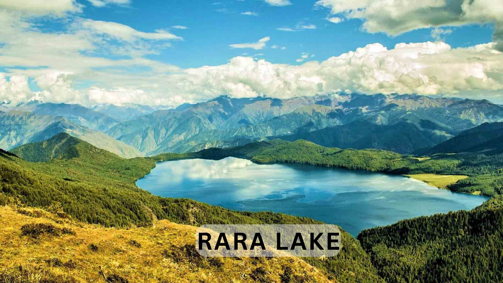
Rara & Murma Ridge: Big-Sky Quiet in Nepal’s Smallest Park
Why It Stands Out
Rara National Park protects Nepal’s largest and deepest lake—Rara (10.8 km², 167 m max depth) ringed by blue pine and alpine meadows. The official park page outlines the lake’s dimensions and seasonal access, while Rara is also a designated Ramsar site (No. 1695) with an active site management plan.
Highlights
A quiet circuit along Rara’s shore, sunrise from Murma and Chuchemara ridges, and winter birdlife on calm days.
Access & Permits
Most itineraries fly to Talcha (Rara) Airport and walk to the lakeshore; overland approaches from Jumla or Surkhet offer a fuller trek.
Best Season & Notes
September–November gives crisp visibility; April–May brings flowers. Winter storms can close high passes; plan buffer days and carry cold-weather gear.
Humla & the Limi Valley: Old Trade Trails and Vasts of Sky
Why It Stands Out
Humla sits at Nepal’s far northwest, where trans-Himalayan trade routes still define movement. The Limi Valley—Gurungs, Tibet-influenced architecture, and wide valleys—remains one of the country’s least-visited trekking frontiers.
Access & Permits
Fly to Simikot, then trek west into Limi (Cha-Sera, Halji, Til). The Revised TIMS list explicitly includes Humla Limi Valley Trek among guided-and-TIMS routes, and the Department of Immigration classifies parts of Humla as restricted, requiring RAP.
Best Season & Notes
Autumn for reliable weather; spring for wildflowers. Expect basic lodging or camping and long stages between settlements.
Khaptad: Meadows Above the Clouds
Why It Stands Out
In Nepal’s far west, Khaptad National Park offers rolling subalpine meadows, mist-tipped forests, and a network of hermitage sites associated with Khaptad Baba. The official park page and brochure outline its mosaic of habitats and cultural sites.
Highlights
Khaptad Patans (grasslands), seasonal wildflowers, and quiet forest ridges—ideal for walkers who prefer solitude to altitude.
Access & Permits
Common gateways include Dhangadhi (by air/road) and then a road-and-foot approach to park entry; plan for basic accommodation and self-sufficiency in supplies.
Best Season & Notes
Late spring and autumn. Monsoon saturates meadows; winter can be icy on open ridges.
Makalu-Barun & the Arun Valley: Wild, Steep, and Biodiverse
Why It Stands Out
Makalu-Barun National Park is a biodiversity hotspot with cloud forests, cliffs, and high passes, supporting species like red panda and snow leopard. Official park information lists core wildlife, birds, and the classic access via Tumlingtar.
Highlights
Barun gorge, Shipton-La options on the Makalu Base Camp route, and side valleys that see far fewer trekkers than Khumbu.
Access & Permits
Fly Kathmandu → Tumlingtar, then trek north; camping dominates away from villages. The TIMS requirement applies; no RAP for the standard base-camp approach, but check any side valleys near sensitive borders.
Best Season & Notes
Autumn for long views; spring for rhododendrons and birdlife. Terrain is steep—build reasonable daily elevation targets.
Rolwaling & Tsho Rolpa: A Quiet Corridor Between Giants
Why It Stands Out
Gaurishankar Conservation Area (GCA) links Sagarmatha and Langtang, forming a biological corridor across altitudinal bands from pine to alpine scrub. The official project page highlights its 2,179 km² span and cultural diversity.
Highlights
The Tsho Rolpa glacial lake, monastery hamlets, and the demanding Tashi Labtsa pass (technical mountaineering experience required) that connects to Khumbu.
Access & Permits
Road heads in Dolakha give access to the lower Rolwaling valley; TIMS and guide are required under current provisions for Rolwaling and Tashi Labtsa treks.
Best Season & Notes
Autumn and late spring. Expect basic teahouses early on, then camping as you climb.
Manaslu & Tsum: Monasteries, Mani Walls, and a High Pass Done Right
Why It Stands Out
Manaslu Conservation Area (MCA)—managed by NTNC—combines glacier-laced scenery with living Tibetan-influenced culture. Tsum Valley adds gompas like Mu and Rachen while the Larke La gives a proper high-pass finale. The MCAP page details the conservation model and community participation.
Highlights
Nubri and Kutang sub-valleys, stone hamlets framed by prayer flags, and wildlife ranging from musk deer to snow leopard.
Access & Permits
Manaslu and Tsum sections include restricted zones—plan RAP, MCA entry, and TIMS with a licensed agency. The official TIMS page confirms guide-and-card rules here.
Best Season & Notes
Autumn for stable weather; spring if you prefer flowers and fewer people on the early approach.Kanchenjunga: Nepal’s Community-Managed Frontier
Why It Stands Out
Kanchenjunga Conservation Area (KCA) is Nepal’s first community-managed protected area, a landmark approach documented by conservation partners and the project’s history. Transboundary by nature, KCA links reserves across India and China, anchoring the Sacred Himalayan Landscape.
Highlights
North and South base camp routes, rhododendron forests that give way to high glaciers, and villages where community committees guide conservation decisions. Recent international initiatives emphasize inclusive governance and biodiversity monitoring.
Access & Permits
The TIMS requirement applies in Kanchenjunga (guide mandatory), with park entry through KCA. Logistics and distances make this a serious multi-week trek.
Best Season & Notes
Autumn for views; late spring for blooms—both avoid winter snowpack on higher traverses.
Travel Logistics That Save Time (and Headaches)
Air Gateways to the Back-of-Beyond
-
Dolpo: Juphal (Dolpa) Airport—primary entry for Phoksundo and Lower/Upper Dolpo circuits.
-
Humla/Limi: Simikot Airport (IMK)—staging point near the Tibet border.
-
Rara: Talcha (Rara) Airport (VNRR)—short trek to the lakeshore.
Why Build Buffer Days
STOL strips are weather-sensitive; fog, wind, or precipitation can delay flights. Choosing a guide familiar with local patterns reduces unexpected bivouacs and keeps resupply sane.
Where Your Money Helps Most: Community Stays & Local Services
Community-run lodging spreads income to places that rarely see tour buses. Nepal’s Community Homestay Network (CHN) aggregates homestays across the country—including rural and mountain communities—so stays are vetted for safety and standards. International recognition and sector reporting show the model’s growth and impact.
Use homestays in staging towns before/after remote treks (e.g., Panauti, Kirtipur, Nagarkot) or in lesser-known hill villages to add cultural depth without adding miles.
Responsible Travel: Simple Habits, Big Difference
-
Pack out all waste; carry a sealable trash bag and micro-mesh strainer for greywater.
-
Walk on durable surfaces; in meadows like Khaptad, stay on existing paths.
-
Respect wildlife; keep binocular distance, especially in alpine zones that shelter red panda, musk deer, and raptors.
-
Use local guides and porters; they manage risk on little-marked trails and amplify community benefits.
Putting It Together: Two Sample Slow-Travel Arcs
Arc 1: Far-West Quiet (14–18 days)
Dhangadhi → Khaptad meadows (4–5 days) → overland to Rara (Talcha access, 3–4 days on foot) → Murma ridge side trip → exit via Jumla or reverse. This chain emphasizes meadows, lake ecology, and village life over high passes.
Arc 2: High Valleys & Blue Lakes (18–24 days)
Kathmandu → Juphal → Phoksundo circuit (Lower Dolpo) → optional extension toward Shey Gompa (permit/time allowing) → return to Juphal. Pair with cultural days in Nepalgunj or homestays near Kathmandu.
Evidence Snapshot: Conservation & Access at a Glance
-
Protected Areas: 23.39% of Nepal’s land; 12 national parks, 6 conservation areas.
-
TIMS & Guides: Mandatory on most routes since March 31, 2023; includes Dolpo, Limi, Rolwaling, Manaslu, Kanchenjunga.
-
Restricted Permits: RAP required in specified border areas (e.g., Upper Dolpo, Nar-Phu, Limi, parts of Manaslu-Tsum).
-
Phoksundo: ~145 m depth; Ramsar site.
-
Rara: 167 m depth; Nepal’s largest lake; Ramsar site with a current management plan.
-
Makalu-Barun: Home to red panda and snow leopard; Tumlingtar access.
-
Rolwaling/Gaurishankar: 2,179 km² corridor between Sagarmatha and Langtang.
-
Manaslu/Tsum: Community-centered conservation under NTNC.
-
Kanchenjunga: Community-managed protected area; part of the Sacred Himalayan Landscape; active international biodiversity support.
-
STOL Access: Juphal (Dolpo) and Simikot (Humla) are primary air gateways; Talcha serves Rara.
-
Community Homestays: National network with vetted standards and global recognition.
Conclusion
Nepal’s quieter corners aren’t an afterthought; they’re the country at full scale—ecology, culture, and big skies without the crowding. If you plan with current permit rules, build buffer days for weather, and keep your footprint light, places like Dolpo, Rara, Limi, Khaptad, Makalu-Barun, Rolwaling, Manaslu-Tsum, and Kanchenjunga deliver the kind of depth that stays with you long after you unpack. The path is there; all it asks is patience and respect.
FAQs
1) Do I need a guide for these regions?
Yes on most routes. Since March 31, 2023, a licensed guide and TIMS card are mandatory on the majority of trekking itineraries, including Dolpo, Limi, Manaslu, Rolwaling, and Kanchenjunga.
2) Which areas require Restricted Area Permits (RAP)?
Border-adjacent corridors such as Upper Dolpo, Upper Mustang, Manaslu-Tsum sectors, Nar-Phu, and parts of Humla (Limi Valley). Agencies handle paperwork; verify current fees on the Department of Immigration site.
3) Is Phoksundo deeper than Rara?
Official documents list Rara at 167 m, while Phoksundo is documented around 145 m; both are Ramsar wetlands. Phoksundo is often called the second deepest high-mountain lake; always defer to park plans for the most conservative figures.
4) What’s the best season for far-west routes like Khaptad and Rara?
September–November and April–May offer clear weather and stable trails. Winter can be harsh; monsoon brings mud and leeches on low approaches.
5) How can I keep my impact low in fragile valleys?
Follow Leave No Trace (plan ahead, stay on durable surfaces, pack out waste, respect wildlife) and choose community homestays to keep benefits local.
Nepal Related Topics