


Overview
Panchkhal Municipality (पाँचखाल नगरपालिका, पाँचखाल, काभ्रेपलाञ्चोक) is one of the local governments of Kavrepalanchok district, Bagmati Pradesh, which was formed including the former five VDCs of the Government of Nepal, the Ministry of Federal Affairs and Local Development has been established by passing a ministerial decision dated 2071 Baishakh 25. The five former VDCs included in this municipality are Panchkhal, Hoksebazar, Devbhumi, Valuwa, Anaikot, and Satighar Bhagwati respectively. Also, as per the decision of the Government of Nepal dated 2073 Falgun 27, two more former Kharelthok and Koshidekha VDCs and seven former VDCs have been merged to form Panchkhal Municipality after federalism. The total area of this municipality is 103 sq km and the total population is 37797. Currently divided into 13 wards, this municipality is the second-largest municipality in terms of area of Kavrepalanchok district.
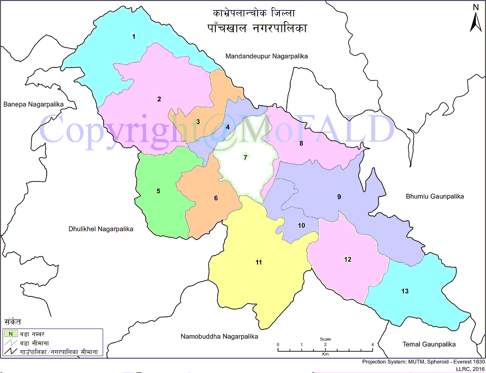
It is bounded on the east by Bhumlu Rural Municipality, on the west by Dhulikhel and Banepa Municipalities, on the north by Mandandeupur Municipality and Bhumlu Rural Municipality Municipality and on the south by Temal Rural Municipality, Namobuddha and Dhulikhel Municipalities. There is a lot of potential for agriculture in Panchkhal municipality. As Palanchok Bhagwati Temple, Anaikot View Tower, Dugdheshwar Temple, Sunkoshi river bank, etc. are known as tourist areas, the local tourism industry seems to have the same potential.
Identification and nomenclature:
Panchkhal municipality is a municipality under the Kavrepalanchok district. This municipality is located in the central part of the district. 45 km from Kathmandu. Panchkhal, located at a distance of 15 km from Dhulikhel, is also the largest flat area in Kavre district. It is located at an altitude of 937 meters or 9273 feet above sea level. This municipality has fertile lands of Panchkhal valley as well as sloping lands of the then Anaikot, Hoksebazar, Satighar Bhagwati VDCs. There is a lot of potential for agricultural production and animal husbandry as well as the domestic tourism industry.
Geographical Condition:
Panchkhal municipality is surrounded by hills of Palanchok, Anaikot, Raviopi, Jaishithok, and Pallekhet around the valley. The average temperature here is 32 degrees to 33 degrees. Although this valley is muddy, irrigated by the Jingu rivers, there was no settlement here as one used to visit this place. Although previously only a settlement of Danuwar castes, the attraction of other castes has been increasing due to the development of highways. The climate in this municipality is varied according to the season as it is summer from April to early September and winter from September to February. As it is a geographically heterogeneous municipality, its height and location are different. Monsoon rains occur in summer and rainy seasons. Due to the influence of monsoon winds, about 2000 ml of average rainfall is found. As this municipality falls in the southeast monsoon affected area, there is plenty of rain from June to September. The two main reservoirs of the district, Bagmati and Roshi, receive less rainfall due to low pressure. Both these reservoirs fall in the rain shadow of the Mahabharata region.
Geographical Map of Panchkhal Municipality:
Contact Address:
Location: Panchkhal, Kavre, Bagmati Pradesh, Nepal
Telephone: +977-11-499451
Email: [email protected]
Website: panchkhalmun.gov.np