


Overview
Yangwarak Rural Municipality (Gaunplika - याङवरक गाउँपालिका, थर्पु, पाँचथर, कोशी प्रदेश, नेपाल), Panchthar- According to the federal structure of the Federal Democratic Republic of Nepal, Panchthar District is situated in Koshi Province. Previously part of Mechi Zone under the older administrative divisions, the district now includes eight local units: one municipality and seven rural municipalities.
Yangwarak Rural Municipality lies in the far northeastern region of Panchthar. It was formed by merging five former Village Development Committees: Chyangthapu, Phalaicha, Oyam, Tharpu, and Nagi. It also shares a border with India.
Geographically, the rural municipality spans from Khade Nagi (Yangwarak-4) at an altitude of 609 meters to the summit of Phalaicha (Yangwarak-2) at 4,575 meters above sea level.
Historical Context
Around 1500 BCE, the Kirat people entered Nepal from Tibet via Assam, displacing the Mahispal rulers. They governed the Kathmandu Valley until the Licchavis took over in 162 BCE, prompting the Kirats to move eastward. Historical accounts classify the region into Upper Kirat (Ramechhap, Udayapur, Khotang, Bhojpur, Okhaldhunga), Middle Kirat, and Lower Kirat (Taplejung, Tehrathum, Sankhuwasabha, Panchthar, Dhankuta, Ilam), with the latter also known as Limbuwan.
The Kirats considered Chaudandi as their capital, while the Limbus governed their regions from Bijaypur. These groups enjoyed autonomy and administered their areas independently.
Unification of Nepal and Local Administration
To resist British expansion, King Prithvi Narayan Shah initiated the unification of Nepal, incorporating 22 states in the Karnali region, 24 in Gandaki, and principalities in the east. Bijaypur was annexed into Nepal in 1774 AD. It's King Karnasen and Minister Buddhikarna Rai fled to Sikkim, and the Ilam region was later handed over to Nepal in compensation.
Following the integration of Limbuwan, local leaders were appointed to administrative roles, such as “Thari,” “Jimmawal,” or “Subba.” An assembly at Tharpu Kalika Dham, led by Limbuwan chiefs, formalized regional customs and practices.
According to historical documents, in 1896 BS, Shree Kamphu Nishan Matpal Singh Mabo of Tharpu was entrusted with administrative duties. In 1908 BS, Shree Jangi Nishan Bagdal Seling of Oyam took over.
A large gathering of 17 Thum, 16 Thari, and 52 Subbas was held at Tharpu’s Kalika Dham, establishing the practice of transferring authority during Dashain. This ritual, which involves ceremonial items such as swords, drums, tridents, and traditional musical instruments, is observed annually. Leaders take turns holding these items and participating in Dashain rituals.
The Kalika Dham is now recognized as a spiritual and communal hub, where annual meetings, discussions, and cultural events continue to take place.
Kalika Devi Mata Dham: A Sacred Site
At the base of a massive oak tree lies the natural and sacred site of Kalika Devi Mata, believed to predate human settlement. It is said that gods and goddesses bathed in the nearby lake, known in the Limbu language as “Mangwarak.” Over time, the lake was referred to as “Hangwarak” (the king’s bathing lake) and later as “Yangwarak” (the lake of money) due to the offerings seen during rituals.
The site still retains features characteristic of a large lake, including flat terrain, over 25 water springs, and approximately 10 ropani of marshland. Local beliefs hold that Kalika Devi emerged from the roots of an oak tree and now resides in the temple.
To the south lies a 7-ropani marshland area and above it, the sacred “Siddha Than” and “Siddha Pond.” The continuous flow from twin water spouts, known as “Jordhara,” led to the area being named after it. Eight active water spouts are visible today. The outflow from Jordhara joins Yangwarak Khola, which meets the Kabeli and Iwa Rivers at a sacred confluence recognized as a Triveni.
The temple grounds, covering around 20 ropani, host annual fairs where thousands of devotees gather for rituals and celebrations.
Geography and Topography
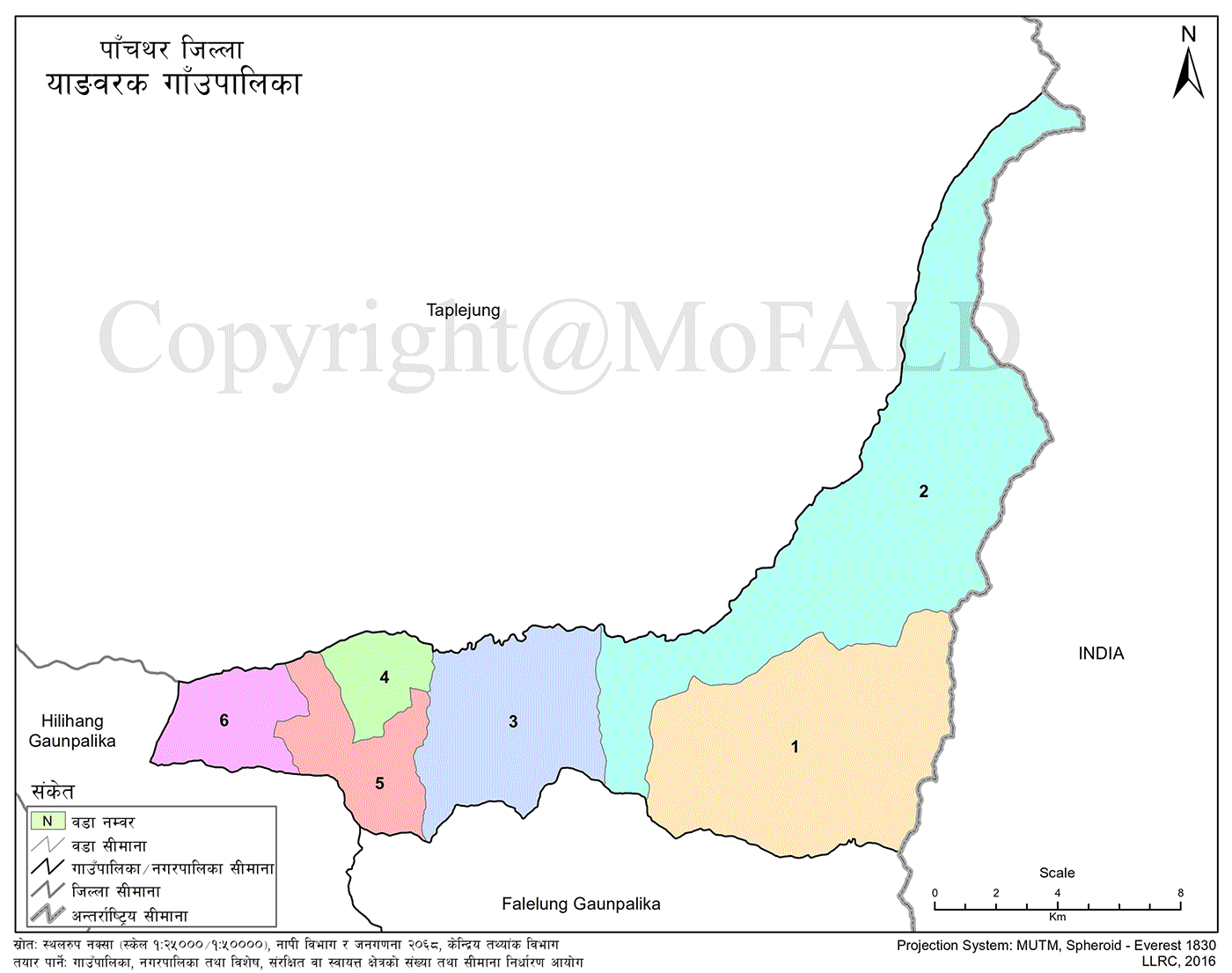
Yangwarak lies between latitudes 27.270°N and longitudes 87.860°E. It borders India’s Sikkim to the east, Hilihang Rural Municipality to the west, and Taplejung's Pathibhara Yangwarak, Sirijanga, and Siddhingwa Rural Municipalities to the north. The southern boundary connects with Falelung and Hilihang Rural Municipalities.
The area consists mostly of hilly and high-hill terrain, ranging in elevation from about 600 meters (Nagikhade in Yangwarak-6) to 4575 meters (Phalaicha Peak in Yangwarak-2). The total area is 208.63 square kilometers.
As per the 2011 census, the population was 18,281. The Middle Hill (Pushpalal) Highway originates at Chiwabhanjyang in Chyangthapu. It passes through Chyangthapu Bazaar, Phalaicha, Oyam, Tharpu, and Nagi, eventually connecting to Hilihang Rural Municipality. Unpaved roads link all wards and neighboring areas in Taplejung.
Administrative Division and Infrastructure
Yangwarak Rural Municipality was restructured by merging five former Village Development Committees (VDCs) and is now divided into six wards.
Climate and Agriculture
The area experiences a range of climates, including tropical, subtropical, temperate, and alpine. This variation supports the cultivation of:
-
Cardamom, amriso (broom grass), and chiraito (medicinal herb)
-
Rice, maize, wheat, potato, peas, millet, legumes, and oilseeds
-
Seasonal and evergreen fruits like mango, litchi, banana, jackfruit, guava, and orange
-
Ginger, tea, and various vegetables
Livestock farming is common, including:
-
Cows, buffaloes, yaks, sheep, goats, pigs, and poultry
Governance and Development Goals
Following Nepal's first local election under the federal structure, Yangwarak received its first elected local representatives. The rural municipality has established:
-
Village Assembly
-
Executive Body
-
Judicial Committee
According to the Local Government Operation Act, 2074, subject-specific committees were established to effectively manage development plans and budgets.
The fifth Village Assembly adopted the slogan:
“Promoting agriculture, forests, tourism, and an inclusive society—Sustainable development and prosperity toward socialism: Yangwarak’s aspiration.”

.jpg)


