


Overview
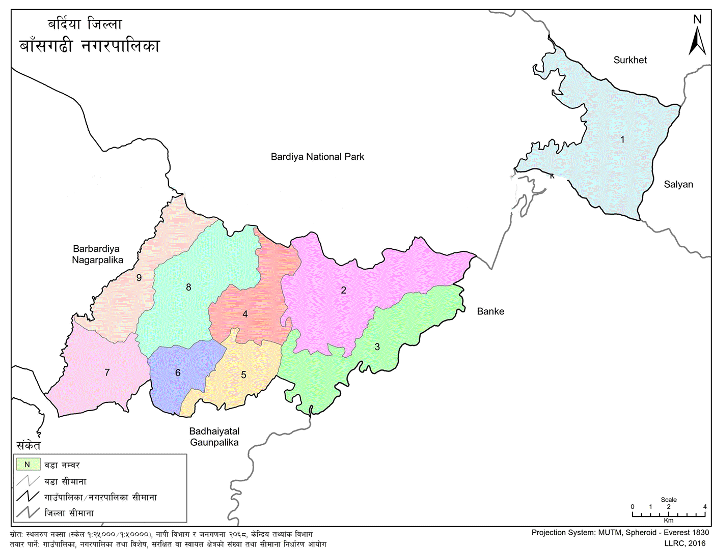
Bansgadhi Municipality (Nagarpalika - बाँसगढी नगरपालिका, बर्दिया) is located in Bardiya District, within Nepal’s Lumbini Province. It was officially established on Mangsir 16, 2071 BS as one of the 61 municipalities declared by the Government of Nepal. The municipality was formed by merging three former Village Development Committees: Beluwa, Motipur, and Deudhakola.
Situated about 25 kilometers northeast of the district headquarters in Gulariya, Bansgadhi lies along the East-West Highway, which runs through its center. It shares borders with Kaprechour of Salyan and Mankhola of Banke to the east, the Gyang River and Barbardiya Municipality to the west, Bardiya National Park to the north, and Badhaiyatal Rural Municipality to the south.
The municipality spans a total area of 206 square kilometers, stretching from 28°13′N to 28°24′N latitude and 81°25′E to 81°46′E longitude. Its terrain includes some Chure hills in the north and flat Terai land in the south.
How Bansgadhi Got Its Name
Before Bardiya National Park was established, the Tharu community living in this region had a custom of collecting bamboo from nearby forests while visiting their in-laws. Many settled in the current Bansgadhi area to make bamboo strips and household items. Locals believe the name “Bansgadhi” (meaning bamboo settlement) comes from this tradition.
Some say the name came from the dense bamboo forests once found in what is now Ward No. 5. Others link the name to traditional folk songs, known as Reukulo, which mention “Bansgadhi village.” All these versions point to a deep-rooted cultural connection between the land and its people.
Climate and Weather
Bansgadhi sits at an elevation of around 154 meters above sea level. The climate here ranges from tropical monsoon to subtropical. On average, the area receives about 1130 mm of rainfall annually. Summers can get quite hot, with temperatures reaching up to 43°C, while winters can dip as low as 7.5°C.
Cultural and Scenic Attractions
Bansgadhi is home to several natural and cultural landmarks. Some notable attractions include:
-
The buffer zone of Bardiya National Park
-
Traditional Chepang village
-
Local temples, churches, and monasteries
During festivals like Shivaratri, Dashain, Maghe Sankranti, and Chaite Dashain, people from nearby areas gather here to celebrate. The strong presence of the Tharu community adds a rich cultural flavor, with unique customs and traditions that are still widely practiced.
One of the main spiritual sites in the area is Kedareshwar Dham, located in Ward No. 5, which holds special significance for both locals and visitors.
Rivers, Streams, and Wetlands
Bansgadhi is rich in natural water resources. Key rivers and streams flowing through the municipality include:
-
Babai River
-
Gyang River
-
Man Khola
-
Dunduwa Khola
-
Ghatte Khola
-
Lauhwa Khola
-
Akshekhiya Khola
-
Shebhang Khola
-
Dondre Khola
-
Khote Khola
-
Bhangaha Khola
-
Dovan Khola
-
Chisi Khola
-
Chapla Nala
-
Fohiya Nala
-
Kanjarwa Nala
-
Boksiniya Nala
Major lakes and wetlands include:
-
Lakshmana Lake
-
Motipur Lake
-
Damauli Lake
-
Bansgadhi Lake
-
Chyama Wetland
-
Ranjha Wetland
These water bodies play an important role in the local ecosystem and agriculture.
Land Use and Farming
Bansgadhi’s landscape is mostly flat, which makes it ideal for farming. The soil is primarily loamy and silty—fertile and well-suited for crop production. According to the Municipality’s Annual Development Plan (2073/074), land use in the area is divided as follows:
-
40% farmland
-
50% forest
-
3% shrubland
-
3% grassland
-
2% rivers and ponds
-
1% gravel/sandy soil
-
1% dense settlements
The major crops grown in this area include:
-
Rice
-
Wheat
-
Maize
-
Lentils
-
Peas
-
Mustard
-
Pigeon pea
-
Black gram
-
Potato
-
Chickpeas
Farming remains the backbone of the local economy, supported by the region’s fertile soil and access to water.

.jpg)


