


Overview
Rajapur Municipality (Nagarpalika - राजापुर नगरपालिका, वर्दिया), located in Bardiya District of Lumbini Province, Nepal, spans a latitude range of 28°21'25.16" to 28°29'43" north and a longitude range of 81°3'25.63" to 81°12'52" east. It lies at an elevation ranging from 142 to 154 meters above sea level.
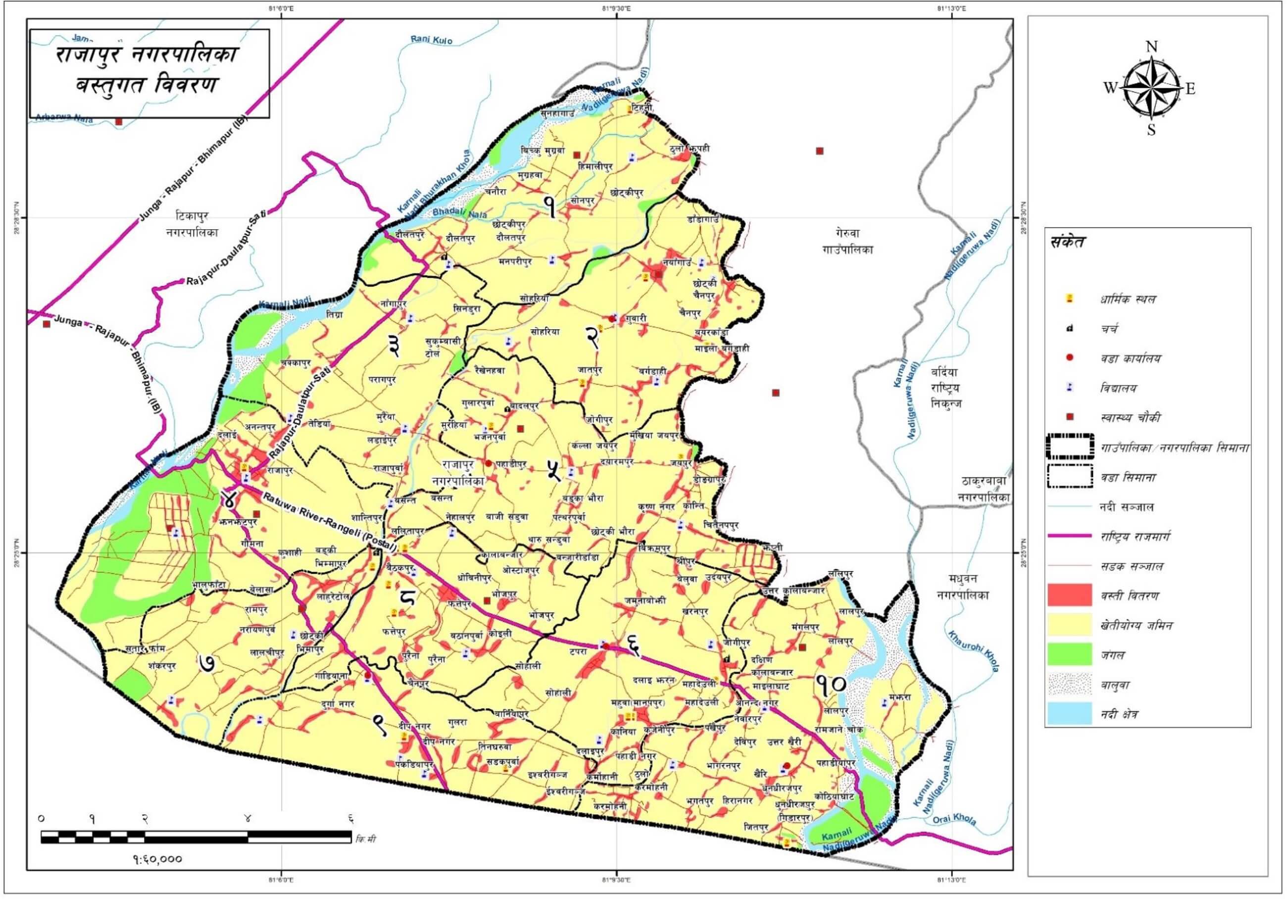
Covering a total area of 127.08 square kilometers, the municipality borders Geruwa Rural Municipality and Kailali District to the north, Kailali District to the west, India to the south, and Madhuwan Municipality to the east. Rajapur is an agriculturally rich area with historical and religious significance.
Formation and Historical Background
Rajapur Municipality was officially declared on 2071 Poush 25 by merging the former Village Development Committees (VDCs) of Daulatpur, Nayagaun, Rajapur, Badalpur, Bhimmapur, and Manpur Tapara, initially comprising 19 wards.
On 2073 Falgun 22, the former Rajapur Municipality and Khairichandanpur VDC were merged to form the current Rajapur Municipality, which comprises 10 wards.
The name "Rajapur" has multiple historical references. It is believed to be named after Raja Ram Kurmi. At the same time, another belief suggests that the area was once inhabited by the Thakuri caste kings, leading to the place being named Rajapur after successive rulers.
Educational Institutions
There are 50 schools and 75 early childhood development centers in the municipality:
-
29 basic schools (Grades 1–5)
-
9 basic schools (Grades 1–8)
-
6 secondary schools (Grades 1–10)
-
6 higher secondary schools (Grades 1–12)
These institutions attract students not only from within the municipality but also from neighboring municipalities and districts.
Social Composition and Demographics
According to the 2077 survey on household data, drinking water, sanitation, and hygiene, Rajapur Municipality has a total population of 69,873—comprising 34,561 females and 35,312 males. The ethnic and religious composition includes:
-
56,667 individuals (81.1%) from the Terai Janajati community
-
7,337 (10.5%) from the Hill Brahmin/Chhetri group
-
2,522 (3.61%) from the Hill Dalit community
This multicultural community celebrates a diverse range of festivals, including Dashain, Tihar, Maghi, Holi, Gaura, Krishna Janmashtami, Bakra Eid, Aitabari, Chhath, Buddha Jayanti, and Christmas.
Economic and Development Aspects
Rajapur’s economy heavily depends on agriculture, with foreign employment being another primary source of income. While traditional farming methods remain common, residents are increasingly adopting modern lifestyles and seeking alternative income opportunities. A significant number of the local workforce migrates abroad for labor and education.
Despite infrastructural development like electrification in most households, some marginalized groups still lack access to electricity. The municipality has faced challenges in implementing planned development due to financial and administrative constraints.
Political and Administrative Information
Political and Administrative Center
The political and administrative center of Rajapur Municipality is the former office of Rajapur Municipality. The local governance officially began on 2071 Jestha 5. The municipality is divided into 10 wards and hosts 24 polling centers.
As per the final voter list of Local Level Election 2074 (for citizens aged 18 and above by Falgun 9, 2073), the total number of eligible voters was 39,287.
Establishment of the Municipality
Rajapur Municipality was formed on 2071 Poush 25 by merging the former VDCs of Daulatpur, Nayagaun, Rajapur, Badalpur, Bhimmapur, and Manpur Tapara with 19 wards. Following the recommendation of the Commission for Determining the Number and Boundaries of Local Bodies, as per Article 295 (3) of the Constitution of Nepal, the Government of Nepal decided on 2073/10/22 to restructure municipalities.
Based on the committee report submitted on 2073/11/20 under the coordination of the Federal Affairs and Local Development Minister, the current Rajapur Municipality was officially formed on 2073/11/22 by incorporating Khairichandanpur VDC and reorganizing the wards into 10.
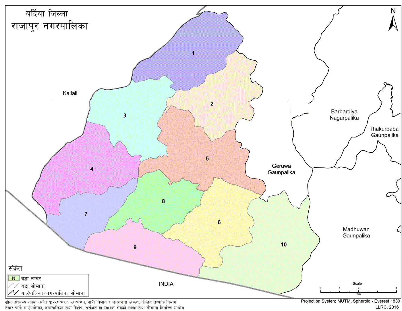
Ward Division of Rajapur Municipality
The municipality is divided into 10 wards as detailed below:
-
Ward 1: Former Rajapur Municipality, Wards 1 and 2
-
Ward 2: Former Rajapur Municipality, Wards 3 and 4
-
Ward 3: Former Rajapur Municipality, Wards 5, 6, and 10
-
Ward 4: Former Rajapur Municipality, Wards 11 and 12
-
Ward 5: Former Rajapur Municipality, Wards 7, 8, and 9
-
Ward 6: Former Rajapur Municipality, Wards 16 and 17
-
Ward 7: Former Rajapur Municipality, Ward 13
-
Ward 8: Former Rajapur Municipality, Wards 14 and 15
-
Ward 9: Former Rajapur Municipality, Wards 18 and 19
-
Ward 10: Former Khairichandanpur VDC, Wards 1 to 9
Geographical Setting
Rajapur Municipality, located in Bardiya District of Province No. 5, lies in the flat Terai plains. Geographically, it stretches from 28°21'25.16" to 28°29'43" north latitude and from 81°3'25.63" to 81°12'52" east longitude. The elevation ranges from 142 to 154 meters above sea level. The total area of the municipality is 127.08 square kilometers. It shares borders with Geruwa Rural Municipality and Kailali District to the north, Kailali District to the west, India to the south, and Geruwa Rural Municipality to the east.
Topography
Soil Composition and Fertility
Rajapur Municipality has fertile land that is favorable for agriculture. Approximately 81.24% of the total land area is arable, while water bodies account for 3.29%. Major crops cultivated in the region include rice, wheat, maize, black gram, lentils, pigeon pea, linseed, and mustard.
Land Classification
The municipality’s land has been classified based on soil structure, ecological system, and susceptibility to erosion. The gradient across the area ranges between 1.3 and 6 degrees. Most of the land is flat, and due to this terrain, there is minimal variation in slope across the municipality.
Climate
Rajapur experiences a tropical to subtropical climate. While seasonal variation exists, the overall pattern is not extreme. The hot season begins in Chaitra and lasts until early Ashwin. Months like Ashwin, Kartik, and Falgun are moderately temperate, whereas Mangsir, Poush, and Magh are relatively cold. Monsoon rains fall mainly from late Jestha to early Ashwin.
Although temperature data is not recorded locally, estimates are based on the climate of Bardiya District. During summer, the average maximum temperature can reach up to 41°C, while in winter it can fall as low as 7°C.
Prospects and Opportunities
The municipality offers a wide range of economic development opportunities, including agriculture, trade, service-based occupations, transportation, information technology, education and training centers, financial services, and aquaculture in rivers and ponds.
Agriculture remains the primary livelihood for most households. There is great potential for cultivating a variety of crops, including cash crops, fruits, sugarcane, oilseeds, vegetables, herbs, and animal-based products. However, the lack of modern agricultural tools, fertilizers, and high input costs has limited productivity. With improved awareness, enhanced skill development, technology transfer, and access to essential inputs such as credit, fertilizers, and seeds, agricultural output can be significantly increased.
The fertility of the land is gradually declining due to unplanned settlements and a lack of scientific agricultural planning. Repairing traditional irrigation canals and managing urban expansion could help restore soil fertility and reduce environmental pollution, ensuring a sustainable future.
There is also high potential for expanding dairy and livestock farming in the rural areas. By improving transportation access and establishing milk chilling centers, cold storage facilities, and meat-processing industries, local employment can be generated and income increased.
If natural resources are managed using environmentally friendly technologies, local employment can be created, and sustainable use of resources can be ensured. The Karnali River’s islands offer the potential for aquaculture. Developing fish farms could reduce dependency on imported fish and provide local job opportunities.
With rising unemployment in both government and non-government sectors, foreign employment has become a major alternative. However, by providing vocational training to local youth and generating employment domestically, significant contributions can be made to the local economy.
Developmental Recommendations
-
Utilize river and stream water for irrigation through modern canal systems to increase agricultural output.
-
Upgrade and blacktop earthen roads to improve access and enhance the municipality’s overall appearance.
-
Strengthen commercial agriculture, particularly vegetables and livestock, due to accessible market opportunities.
-
Promote agriculture-based industries to expand local employment opportunities.
-
Capitalize on religious, cultural, and historical sites to develop tourism.
-
Leverage partnerships with active government, non-government, and private development organizations.
-
Encourage the development of industry, trade, and commerce to meet the growing consumer base.
Problems, Challenges, Opportunities, and Potential
Opportunities and Potential
-
Availability of fertile land, rivers, flat terrain, and biological diversity.
-
Increasing number of educated human resources.
-
Dominance of the youth population.
-
Connectivity with national highway infrastructure.
-
Availability of educational centers.
-
Prospects for tourism development based on religious, historical, and natural significance.
Problems and Challenges
-
Absence of employment-generating industries and factories.
-
Lack of proper drinking water infrastructure.
-
Many roads within the municipality remain unpaved and of low quality.
-
Despite fertile land, commercial agriculture is underdeveloped.
-
Limited income sources affect development investment capacity.
-
Lack of organized development planning.
-
Reliance on rain-fed irrigation.
-
Continuation of subsistence farming practices.
Inter-Municipality and Rural Municipality Relations
Municipalities are inherently interconnected. These connections vary in nature and proximity. For human development, mobility between regions is essential, as is the shared use of available resources. Key areas of interdependence include transport, migration, agriculture and livestock products, forest resources, tourism, employment, natural resource management, education, and health services.
Rajapur Municipality frequently receives people from other municipalities and rural areas seeking services. Agricultural and forest products from the hills are brought into the Terai. The Terai, being more developed than hill regions, attracts significant migration. Due to better access via air and road transport, people frequently travel to and from resource-equipped municipalities.
Seasonal migration from the hills to the Terai for employment is common, strengthening inter-municipal relations. Rajapur Municipality also maintains strong ties with neighboring local governments and government agencies such as the District Coordination Committees.
It has established good partnerships with both national and international non-governmental organizations, enabling better coordination in development activities.
Urban Development: Problems and Challenges
With increasing population and rapid urbanization in rural settlements, Rajapur Municipality faces several challenges in planned development:
-
There has been no comprehensive effort to develop settlements based on urban planning principles. Zoning for residential, industrial, open/public, green, institutional, and office areas in both urban and rural regions has not yet been implemented.
-
There is a lack of organized public and private efforts to plant trees, which hinders environmental improvement. Waste disposal and its unmanaged processing are contributing to environmental degradation. Urban settlements also lack systems to manage stray animals and dedicated livestock markets. The release of untreated sewage into rivers and canals is causing water pollution, highlighting the need for proper wastewater treatment infrastructure.
-
Infrastructure development has suffered due to poor coordination among government bodies, preventing the sustainable implementation of public construction projects. Greater collaboration is needed between local authorities and civil society.
-
A scientific settlement plan must be developed for Rajapur Municipality, including a master plan that outlines designated areas for housing, commerce, industry, parks, gardens, playgrounds, public institutions, and offices.
Wetland Areas
Wetlands include rivers, streams, ponds, springs, wells, and marshes—areas where water accumulates and does not drain easily. No formal records of natural lakes or larger ponds exist in the municipality. However, some small ponds are present throughout the region.
Rivers, Streams, and Ponds
Scattered across various wards and regions of the municipality, ponds act as water reservoirs and habitats for aquatic species and birds. These water bodies are also used by livestock for drinking and by farmers for irrigation.
Due to population growth, urban expansion, and excessive grazing by unproductive livestock, many natural ponds are facing sedimentation and degradation. Restoring these water bodies for fish farming can not only supply local fish demand but also support eco-tourism activities such as boating.
Religious, Natural, and Tourist Sites
Nepal is globally recognized as a tourist destination due to its unique geography, diverse climate, rich biodiversity, diverse wildlife, and cultural heritage. Tourism is considered a natural blessing for the nation. With scenic mountain ranges, snow-fed rivers, waterfalls, caves, forests, ethnic diversity, and traditional lifestyles, the country has vast tourism potential.
Proper utilization of these assets can contribute significantly to national economic development. Nepal’s Tourism Policy 2065 aims to promote employment through tourism, reduce poverty, preserve tangible and intangible heritage, and develop infrastructure for sustainable tourism.
Rajapur offers natural beauty, rich biodiversity, ethnic and religious diversity, and cultural landmarks that can attract both domestic and international tourists. In the global era shaped by advancements in science, communication, and transportation, Nepal has the opportunity to showcase its treasures to the world and draw more tourists, thereby strengthening its economy.
For tourism to flourish, Nepal must protect its resources while expanding its infrastructure, including air routes and land connectivity. Lakes, rivers, wetlands, and scenic views in Rajapur attract many visitors. Promoting tourism can improve livelihoods and create employment opportunities within the municipality.
Major Festivals Celebrated in the Municipality
Rajapur is home to a diverse population representing various castes, ethnicities, religions, and traditions. Major groups include Koiri/Kushwaha, Chhetri, Tamang, Magar, Yadav, Hill Brahmin, Kami, Newar, and Chamar.
The majority follow Hinduism, with Muslim and Christian communities also present. Each group observes its own religious and cultural practices.
Prominent festivals celebrated include:
-
Dashain
-
Tihar
-
Ram Navami
-
Mahashivaratri
-
Haritalika Teej
-
Saraswati Puja
-
Krishna Janmashtami
-
Bibaha Panchami
-
Chhath (Holi)
-
Chaite Dashain
-
Maghe and Saune Sankranti
-
Maghi
-
Gai Jatra
-
Matatirtha Aunsi
-
Akshaya Tritiya
-
Harishayani and Haribodhini Ekadashi
-
Nag Panchami
-
Raksha Bandhan (Janai Purnima)
-
Kushe Aunsi
-
Bala Chaturdashi
-
Kojagrat Purnima
-
Gothale Festival
-
Shree Swasthani Brata Katha
-
Nepali New Year
-
Sorha Shraddha
-
Jitiya
-
Siruwa (Tharu-Khawas)
-
Kul Puja
-
Gramthan Puja
-
Karwa Chauth
-
Karkat Sankranti
-
Bhurki Puja
-
Sankat Puja
-
Buddha Jayanti
-
Lhosar (various ethnic groups)
-
Shab-e-Barat
-
Eid
-
Bakr Eid
-
Muharram
-
Gyarvi Sharif
-
Eid-ul-Fitr
-
Christmas
-
Valentine’s Day
-
Gaura
-
Holi
-
Aitabari Festival
-
Devijaat
-
Jestha Purnima (celebrated by Raji community)
-
Charai festival (celebrated by the Rana Tharu community)
-
Bhootuwa Puja
-
Ranuputala (effigy-burning by Brahmins and Chhetris)
-
Anantya
-
Bhuwa (traditional martial performance)
-
Poush 15 celebration
-
Olke
-
Asar 15
-
Ganga Dashahara
-
Bisu Tihare, among others.
Throughout the year, various local fairs (melas) are organized in the municipality, and their details are presented in the following section.

.jpg)


