


Overview
Gulariya is a municipality (Gulariya Nagarpalika) located in Bardiya District, Lumbini Province of Nepal. The name "Gulariya" originates from the Gular tree, which was found in one of its villages. As the administrative headquarters of Bardiya District, Gulariya is one of the eight municipalities within the district.
The municipality was initially formed in 1997 (2053 BS) through the merger of three Village Development Committees (VDCs): Mathurahardwar, Khairapur, and Gulariya VDC. Later, in December 2016 (2073 BS), it was restructured again by incorporating Mahammadpur VDC.
Gulariya is home to people of diverse languages, religions, and cultures, reflecting the essence of Nepal's social fabric. This municipality symbolizes unity, cooperation, brotherhood, and harmony. It is situated beside the sacred Babai River (also known as Saryu). Gulariya stands out as a uniquely serene and culturally rich town. It has its own historical significance and a well-recognized identity in the Bardiya District.
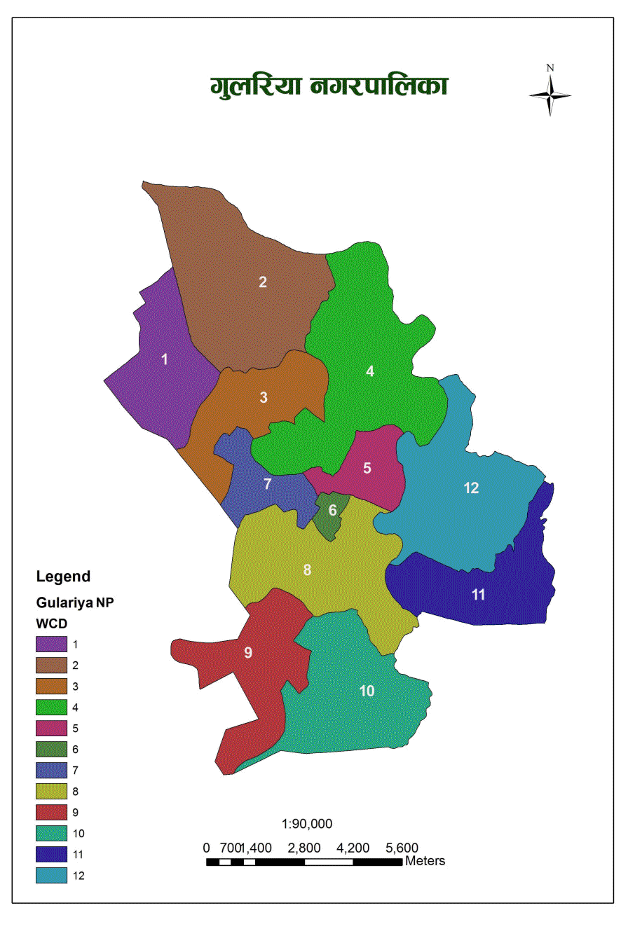
Currently, Gulariya comprises 12 political wards, covering an area of 118.21 square kilometers in the southern plains of the Terai region.
As per the 2021 National Population and Housing Census, Gulariya Municipality had a total population of 74,505 individuals residing in 16,002 households. The male population was 36,727, while the female population was 37,778 (NSO, 2021).
The municipality reported an annual population growth rate of 0.86%, leading to a population density of 630.3 people per square kilometer (City Population, Gulariya, 2021).
Gulariya experiences a hot, humid, and partly cloudy wet season, while the dry season is typically warm and mostly clear. Temperatures throughout the year generally range between 12°C and 39°C, rarely falling below 9°C or exceeding 43°C.
The hot season lasts from April to June, with average daily highs above 97°F (36°C). May is the hottest month, with temperatures averaging 103°F (39°C) during the day and 81°F (27°C) at night.
The cool season spans from December to February, with daily high temperatures averaging below 77°F (25°C). January is the coldest month, recording average lows of 53°F (12°C) and highs of 72°F (22°C).
The clearest skies are typically observed around May, while September marks the onset of reduced cloud cover.
In terms of rainfall, Gulariya shows significant seasonal variation. July receives the most rainfall, averaging 10.5 inches (266.7 mm), whereas November is the driest month, with an average of just 0.2 inches (5.08 mm) of rainfall (Weatherspark, 2023).
Cultural and Religious Sites
Gulariya Municipality is home to several places of natural, religious, and historical significance that are potential tourist attractions. Cultural tourism plays a vital role in this region. Major destinations include:
-
Krishnasar Conservation Area
-
Tulsipur Wetland Area
-
Saryu River Corridor
-
Krishnasar Lake
-
Bhaghar Lake
-
Tharu Museum
-
Parbatiya Temple
-
Kothi Temple
-
Baglamukhi Temple
-
Khand Baba Temple Area
-
Gayatri Shaktipith
-
Nathuniya Baba Shrine
The region is culturally vibrant, with distinct identities of Madhesi and Tharu communities. Alongside, you’ll find the traditions of Nepali-speaking, Awadhi-speaking, Tharu-speaking, Magar, Newar, and Dalit communities—each contributing their own unique cultural richness.
Population and Area
-
Total Population: 74,505
-
Male: 36,727 (49.3%)
-
Female: 37,778 (50.7%)
-
Total Area: 118.21 square kilometers
-
Administrative Division: 12 wards
Geographical Boundaries
-
East: Badhaiyatal Rural Municipality
-
West: Madhuvan Municipality
-
North: Barbardiya Municipality
-
South: Bahraich District, Uttar Pradesh, India
Topography
Gulariya Municipality is located in the western Terai region of Nepal at an altitude of 145 meters above sea level. Its geographical coordinates extend from 28°8′1″ N to 28°17′12″ N latitude and 81°16′49″ E to 81°24′48″ E longitude.
To the east lies Badhaiya Rural Municipality, to the west is Madhuvan Municipality, Barbardiya Municipality borders the north, and the southern boundary connects to Bahraich District, Uttar Pradesh, India. Gulariya is situated 35 kilometers west of Nepalgunj and about 10 kilometers north of the Murtiha transit point and railway station in India.
The municipality lies in a basin area along the Babai River, which supports irrigated and fertile Terai plains (Municipality, Gulariya, 2076).
This strategic location supports future urban expansion, especially with access to the East-West Highway. The Babai River, flowing through the northeastern region, contributes to both irrigation advantages and flood risk challenges.

.jpg)


