


Overview
Thakurbaba Municipality (Nagarpalika - ठाकुरबाबा नगरपालिका) was established by incorporating the former VDCs of Baganaha and Neulapur on Ashwin 2, 2072 BS under Lumbini Province, Bardiya District. Later, Shivpur and Thakurdwara VDCs were merged into it. Officially, the municipality was formed on Falgun 27, 2073 BS.
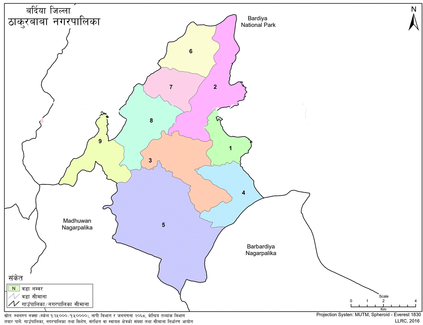
According to the federal structure, this municipality lies in Bardiya District Constituency No. 2 and Provincial Assembly Constituency 2 (A). Geographically, the municipality is surrounded by Bardiya National Park to the east, west, and north, and bordered by Madhuwan Municipality to the south.
It covers a total area of 104.52 square kilometers, with elevation ranging from 144 to 214 meters above sea level. The coordinates span from 81°13’24.69” to 81°21’11.775” E longitude and 28°21’53.63” to 28°31’19.295” N latitude. The population density is 548.55 people per square kilometer.
Administratively, the municipality is divided into 9 wards. According to the Household Survey of 2079 BS, the total population is 57,362, comprising 29,070 males, 28,287 females, and 5 other individuals, with a total of 11,564 households.
Climate and Accessibility
The area experiences an average minimum temperature of 8°C and a maximum of 43°C. The annual average rainfall is recorded at 1120 millimeters. Located 22 kilometers northwest of the district headquarters, Gulariya, Thakurbaba is connected by the East-West Highway and Hulaki Road.
Major market centers within the municipality include Bhurigaun, Baganaha, Shahipur, Bakuwa, and Thakurdwara.
Historical Background and Infrastructure
After the municipality's establishment on Falgun 27, 2073 BS, the Chief Administrative Officer served as the acting executive head for around five months. The local level elections were held on Ashadh 14, 2074 BS, and elected representatives assumed office on Ashadh 22, 2074 BS, forming a complete municipal administration.
Initially operated from a rented house and later from the Neulapur Health Post building, the municipal office has been functioning from its own under-construction building in Ward No. 4, Sainwar, since Bhadra 25, 2077 BS.
Detailed Formation and Demographic Overview
Thakurbaba Municipality was named after the Thakurdwara Temple in Thakurdwara VDC. It includes former VDCs of Baganaha, Neulapur, Shivpur, and Thakurdwara.
Based on the Household Survey of 2077 BS:
-
Total households: 10,454
-
Total population: 57,204
-
Male: 28,860
-
Female: 28,344
-
Geographical coordinates extend from 28°23' N latitude and 81°11' to 81°19' E longitude. The total area is 104.57 square kilometers, with a population density of 534 people per square kilometer.
Altitude averages around 175 meters above sea level. The area experiences average minimum temperatures of 8°C and maximum temperatures of 43°C, with an annual rainfall of 1,120 millimeters.
Thakurbaba is 22 kilometers northwest of Gulariya and well connected to the main highway. Despite some administrative tasks requiring travel to the headquarters, daily necessities are sourced from local markets, including Bhurigaun, Baganaha, Bakuwa, Thakurdwara, and Shahipur.
The municipality is connected to other districts via the main highway and the Bhurigaun-Dhodhari road, facilitating easy travel and transportation. According to the municipal master plan, village settlements are being linked to ward centers, which in turn connect to the municipal center. This network has improved inter-ward accessibility and mobility.
All settlements in the municipality now have year-round, uninterrupted access.
Ward-wise Population and Area Breakdown
-
Ward 1: Includes Babi (1,2)
-
Population: 8,091
-
Area: 5.22 sq.km
-
-
Ward 2: Includes Babi (3,4)
-
Population: 8,578
-
Area: 13.29 sq.km
-
-
Ward 3: Includes Babi (5,7)
-
Population: 8,076
-
Area: 12.57 sq.km
-
-
Ward 4: Includes Babi (6,9)
-
Population: 5,363
-
Area: 8.67 sq.km
-
-
Ward 5: Includes Babi (8,10)
-
Population: 6,025
-
Area: 31.49 sq.km
-
-
Ward 6: Includes Shivpur (1–7)
-
Population: 4,727
-
Area: 8.04 sq.km
-
-
Ward 7: Includes Shivpur (8,9)
-
Population: 5,114
-
Area: 6.39 sq.km
-
-
Ward 8: Includes Thakurdwara (1–4)
-
Population: 5,026
-
Area: 11.06 sq.km
-
-
Ward 9: Includes Thakurdwara (5–9)
-
Population: 6,203
-
Area: 7.84 sq.km
-
-
Total Population: 57,204
-
Total Area: 104.57 sq.km
Political Context and Vision for Development
Since the end of the Rana regime in 2007 BS and the advent of democracy, Nepal has undergone about 70 years of political fragmentation and struggle, resulting in prolonged socio-political transitions.
Although the people transitioned from subjects to citizens with shifts from monarchy to republic, structural foundations for prosperity remained weak. The Constitution of Nepal 2072 BS envisioned social democracy, federal governance, and equitable resource distribution to pave the way for holistic development.
However, the past decades primarily focused on political and civil rights movements. During this time, neighboring countries like India, China, and South Korea made significant developmental progress. Several countries in East and Central Asia have surpassed Nepal in development despite achieving independence after Nepal.
Now, Nepal is beginning the process of infrastructure development.
Democratic Transition and Local Hope
With the Constitution of Nepal 2072 BS and subsequent elections, the restructuring of federal, provincial, and local governments was completed, establishing a new federal democratic republican system.
This period has raised hopes among local residents, who have long endured underdevelopment, poverty, disease, illiteracy, inconvenience, and injustice. People are now beginning to experience changes and services through decentralized governance, which is committed to comprehensive development and economic progress.

.jpg)


