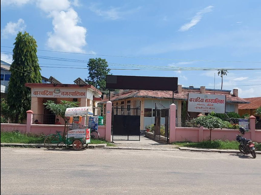
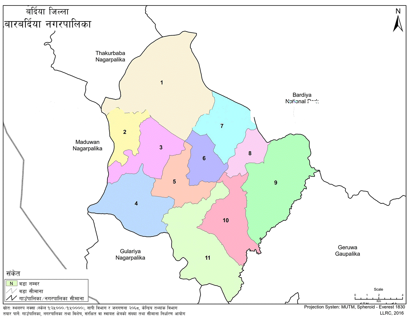
Barbardiya Municipality (Nagarpalika - बारबर्दिया नगरपालिका, बर्दिया), located in Bardiya District of Lumbini Province, Nepal, was officially formed on 27 Falgun 2073 B.S. (March 10, 2017 A.D.) by the Government of Nepal. It was created by merging the former Village Development Committees (VDCs): Baniyabhar, Padanaha, Magaragadi, and Dhadhawar. The municipality consists of 11 administrative wards.
Geographically, it lies between 28°26′ to 28°36′ North Latitude and 81°30′ to 81°50′ East Longitude. The municipality is bordered by:
East: Bansgadhi Municipality
West: Madhuwan Municipality
North: Bardiya National Park and Thakurbaba Municipality
South: Gulariya Municipality
According to the 2021 national census, the municipality has:
Total population: 72,533
Male: 34,126
Female: 38,407
Total households: 16,897
Total area: 226.09 sq. km
Elevation: Approximately 175 meters above sea level
| Category | Details |
|---|---|
| Province | Lumbini Province |
| District | Bardiya District |
| Established | 27 Falgun 2073 B.S. (March 10, 2017 A.D.) |
| Merged VDCs | Baniyabhar, Padanaha, Magaragadi, Dhadhawar |
| Total Wards | 11 |
| Total Area | 226.09 sq. km |
| Elevation | Approximately 175 meters above sea level |
| Latitude Range | 28°26′ to 28°36′ North |
| Longitude Range | 81°30′ to 81°50′ East |
| Total Population (Census 2021) | 72,533 (Male: 34,126 |
| Total Households | 16,897 |
| Bordering Areas | East: Bansgadhi, West: Madhuwan, North: Bardiya NP, South: Gulariya |
| Major Rivers | Babai, Bhadakhola, Dundara, Pathariya, Jharaniya |
| Wetlands and Ponds | Jaruwa Pond, Satkhalwa Wetland, Kalapani Source |
| Climate | Subtropical monsoon; max temp: 43°C, avg rainfall: 1130 mm |
| Tourism Sites | Sadashiv Temple, Barho Bardiya Mandap, Satkhalwa Lake, Ban Baba Temple |
| Main Ethnic Groups | Tharu, Brahmin, Chhetri, Dalit, Magar, Madhesi, Gurung, Rajhi |
| Festivals Celebrated | Dashain, Tihar, Maghi, Krishna Janmashtami, Teej, Holi, Buddha Jayanti |
| Major Occupation | Agriculture, Animal Husbandry, Forestry |
| Education | 93 ECDs, Primary to Higher Secondary Schools, 2 Multi-Disciplinary Campuses |
| Main Campuses | Sadashiv Multiple Campus, Janasewa Multiple Campus |
| Flood-Prone Areas | The low-lying Terai region is affected annually during the monsoon |
Ward 1
Former VDC: Baniyabhar (Wards 1, 2)
Population: 6,171
Ward 2
Baniyabhar (Wards 3, 4, 5)
Population: 5,577
Ward 3
Baniyabhar (Wards 6, 7, 8, 9)
Population: 7,107
Ward 4
Padanaha (Wards 1, 2, 5, 6, 7, 8, 9)
Population: 6,903
Ward 5
Padanaha (Wards 3, 4)
Magaragadi (Wards 1, 3)
Population: 5,754
Ward 6
Magaragadi (Wards 2, 4)
Population: 6,460
Ward 7
Magaragadi (Wards 5, 6, 7, 8)
Population: 6,513
Ward 8
Magaragadi (Ward 9)
Dhadhawar (Wards 2, 7)
Population: 6,303
Ward 9
Dhadhawar (Wards 3, 6)
Population: 7,667
Ward 10
Dhadhawar (Wards 1, 4, 9)
Population: 8,062
Ward 11
Dhadhawar (Wards 5, 8)
Population: 6,016
Location: Mid-region of Bardiya District
Coordinates: 28°26′ – 28°36′ N, 81°30′ – 81°50′ E
Elevation: 175 meters
Topography: Includes Chure Hills to the north and the plains (Terai) to the south
Major Rivers: Babai River, Bhadakhola, Dudhara, Jharaniya, Pathariya
Wetlands and Ponds: Jaruwa Pond, Satkhalwa Wetland, Kalapani Source
The Babai River is a major irrigation source and also contributes to local revenue through the extraction of natural resources, including gravel, sand, and stones.
The name “Barbardiya” is believed to originate from the history of the Tharu community. According to folklore, twelve Tharu herders (locally called Bardibas) once went into the forest. While performing a ritual play involving offerings to deities, ten of them mysteriously disappeared. The remaining two, fearing for their lives, ended their own. In memory of this event, a worship platform named “Barho Bardiya Mandap” was established in Ward 5. The municipality was later named after this site at the request of the local community.
Barbardiya lies in a subtropical monsoon climate zone:
Average annual rainfall: 1130 mm
Maximum temperature: 43°C
Minimum temperature: Around 7.5°C
Barbardiya falls under Province No. 5 (Lumbini Province), in the former Bheri Zone. It comprises parts of Electoral Areas 1 and 2 of Bardiya District and is divided into 11 wards.
Due to its fertile plains, the area primarily practices agriculture and forestry. Key land uses include:
Grain, pulses, and oilseed farming
Vegetable and fruit cultivation
Animal husbandry (traditional and modern)
Dense coverage of community and buffer zone forests
Settlements, market centers, canals, and road networks
The area consists mostly of flat terrain, but scattered rivers, canals, and rivulets interrupt uniformity. Due to its low elevation, the municipality frequently faces flood hazards during the monsoon.
The municipality is rich in natural and cultural heritage. Notable sites include:
Bardiya National Park (buffer zone)
Satkhalwa Lake
Sadashiv Temple (Ward 5)
Barho Bardiya Mandap
Various temples (Shiv, Radhakrishna, Ban Baba, Fennapati, Ban Devi, Kumura Ghat, Mahadev, etc.)
Khairani wetland
Annual traditional fair “Kutimela” in Kumragau during the Maghi festival
Ethnic diversity includes Brahmin, Chhetri, Tharu, Madhesi, Dalit, Magar, Gurung, and Rajhi communities. Major festivals celebrated:
Dashain
Tihar
Krishna Janmashtami
Nag Panchami
Maghi
Teej
Holi
Buddha Jayanti
Lhosar
The municipality includes schools at all levels, from pre-primary to secondary (Grades 1–12). It consists of:
Community ECD Centers: 93
Primary (Grades 1–5)
Lower Secondary (Grades 6–8)
Secondary (Grades 9–10)
Higher Secondary (Grades 11–12)
(Detailed school-wise breakdown maintained in official records.)
WardCampus NameLocationPrograms Offered6Sadashiv Multiple CampusJaynagarHumanities, Education (Bachelor)10Janasewa Multiple CampusDhadhawarManagement, Humanities (Bachelor)
ECD enrollment details across wards are maintained, covering:
School names
Ward numbers
Student count
Village or settlement name
The municipality includes a wide range of ethnic and caste groups. Major categories include:
Gandharva (Gaine)
Pariyar (Damai, Tailor, Musician)
Badi
Bishwakarma (Kami, Blacksmith, Goldsmith)
Sarki (Tanner, Leatherworker)
Dusadh (Paswan, Hajra)
Dhobi (Rajak)
Chamar (Mochi, Ravidash)
Dom, Tatma, Pasi, Khattwe, Musahar
Tharu, Rajbanshi, Danuwar, Majhi, Gurung, Magar, Rai, Limbu, Tamang, Chepang, Newar, Sherpa, etc.
Hill Brahmin and Chhetri
Madhesi Brahmin and Chhetri
Muslims
Others: Yadav, Teli, Kalwar, Kurmi, Barai, Kumhar, Rajbhar, Mallah, etc.
The following is a list of major settlements in each ward of Barbardiya Municipality:
Jamuniya
Sailahi
Launghuwa
Chhotkipur
Dashdharuwa
Rajipur
Jamunaphanta
Madarhawa
Jodhipur
Murgihawa
Pahadipur
Phoolbari
Dangpur
Kusumdanda
Bhangaha
Kumaragaun
Pachgharuwa
Chawanipur
Narayanpur
Dangpur
Jhundi Pur
Gauripara
Dungrahi
Kusumdanda
Pahadipur
Jogigaun
Lamidamar
Jeetpur
Shantipur
Latthawa
Badkapur
Gidaripur
Ghongipur
Bepattapur
Hasnapur
Beluwabajja
Banagai
Mundagauri
Khurkhure
Rampur
Laxmanpur
Baniyabhar
Banahawa
Jabarpur
Muraha
Bhaisakhani
Jhakkipur
Lalpur
Thagpur
Nepalgunj Padanaha
Soharvigha
Bairiya
Jagatiya
Jwalahiri
Guruwagaun
Barwata
Ranipur
Ghorpitta
Fattepur
Banghusri
Bantariya
Gidaripur
Hariyali
Chhotki Puruwa
Sitibareli
Soharvigha
Barbardiya
Bhuthiya
Magaragadi
Pattharpur
Tarkapur
Sadashiv
Jabdahawa
Kandra Tol
Dhobiya
Jaynagar Gaun Tol
Kotharpur
Pragati Pur
Jaynagar
Patthardanda
Jaypur
Bhimsen Tol
Gulra
Manikapur
Manpur
Dhamapur
Shaktinagar
Dullipakariya
Bhotpur
Datafanta
Samjhana Phanta
Sonpur
Tighra
Dhaulagiri Chowk
Siuniya
Simalkhari
Masuriya Phanta
Harnahawa
Banthada
Rammapur
Arairpur
Rajitol
Dangpur
Shivnagar
Schoolpur
Bauddhanagar
Jakhar Tol
Chauki Tol
Bhagatpur
Beech Tol
Shivnagar
Simalkhari
Ramnagar
Mahtan Tol
Jakar Tol
Sukumbasi Tol
Raj Kulo Tol
Bakalbhar
Duddha
Thanphena
Sanjhna Tol
Nakkiphanta
Bargadi
School Tol
Dakshin Tol
Pathariya Tol
Katarnia
Sausahawa
Prasahawa
Banagai
Khairi
Dhakela
Dhadhawar
Hausalpura
Damara
Vaidi
Vaididanda
Gumasta
Vaida
Simrahawa
Meraiya
Dafaiya
Uttar Lamki
Shobhanagar
Jabdi
Khuntipur
Akalgharwa
Fachkaha
Belbhar
Lamkiphanta
Bijayanagar
Schools in Barbadiya provide education from Early Childhood Development (ECD) to Grade 12. The types of schools and classes offered include:
ECD Centers
Primary (Grades 1–5)
Lower Secondary (Grades 6–8)
Secondary (Grades 9–10)
Higher Secondary (Grades 11–12)
The following are Early Childhood Development (ECD) centers and pre-primary schools with student enrollment:
Simrahawa ECD, Ward 10
Bhagwati Primary School, Dhakela, Ward 9
Amar Shaheed School, Khaireni, Ward 9
Vijay Primary, Bijayanagar, Ward 11
Dharmabhakta School, Katarnia, Ward 9
Phaguna Primary, Bakalbhar, Ward 8
Janachetana Primary, Dhadhawar, Ward 10
Janajyoti Secondary, Banagai, Ward 9
Janasewa Secondary, Vaidi, Ward 10
Karuna Primary, Banagai, Ward 9
Kisan Secondary, Pachkhaluwa, Ward 11
Kisnasar Primary, Thanphena, Ward 8
Majdoor Primary, Lamkiphanta, Ward 10
Nepal Pragya ECD, Jabdi, Ward 11
Shaheed Primary, Gaumasta, Ward 10
Singh ECD, Belbhar, Ward 11
Yuwa ECD, Thanphena, Ward 8
Gautam Buddha Primary, Jawarpur, Ward 3
Hamal Kabila Primary, Launghuwa, Ward 1
Jaljala Deepjyoti Primary, Baniyabhar, Ward 3
Janachetana Primary, Narayanpur, Ward 2
Janata Primary, Bantariya, Ward 1
Nepal National Secondary, Sarawati, Ward 3
Sarawati ECD, Jamuniya, Ward 1
Shanti ECD, Kumaragaun, Ward 2
Yuwa Secondary, Jogigaun, Ward 2
Gurujan Shakti Primary, Banghusri, Ward 4
Janashakti ECD, Chainpur, Ward 5
Jwala Janajagriti Primary, Ghorpitta, Ward 4
Kushmadevi ECD, Padanaha, Ward 4
Panchajanya Secondary, Padanaha, Ward 4
Shiv Primary, Padanaha, Ward 4
Anshu Varma Secondary, Jaynagar, Ward 6
Bal Kalyan Primary, Sonpur, Ward 7
Bhagwati Primary, Harnawa, Ward 7
Bhanubhakta Secondary, Siuniya, Ward 7
Janachetana Primary, Dhobiya, Ward 5
Janajagriti Primary, Gulra, Ward 6
Janapriya Primary, Jabdahawa, Ward 5
Janajyoti ECD, Auri, Ward 8
Janata Secondary, Rammapur, Ward 7
Navjyoti Primary, Shaktinagar, Ward 6
Nepal National ECD, Tarkapur, Ward 5
Sarawati Primary, Bhagatpur, Ward 8


.jpg)