


Overview
Lugri Rural Municipality is one of ten local levels within Rolpa District, Lumbini Province, Nepal. Named after the scenic Lugri River, the municipal center is located at Kilachaur, formerly Wardachaur VDC. The municipality is located 35 kilometers northeast of Rolpa's district headquarters, Liwang, and approximately 6 kilometers northeast of Sulichaur Bazaar in Sunil Smriti Rural Municipality.
Area and Population
Covering a total area of 135.23 square kilometers, Lugri Rural Municipality has a population of 26,539, as per the 2021 Census. There are 5,486 households, with 12,348 males and 14,191 females. It was formed by merging five previous VDCs: Wardachaur, Gumchal, Harjang, Pang, and Shirp, and is now divided into seven wards.
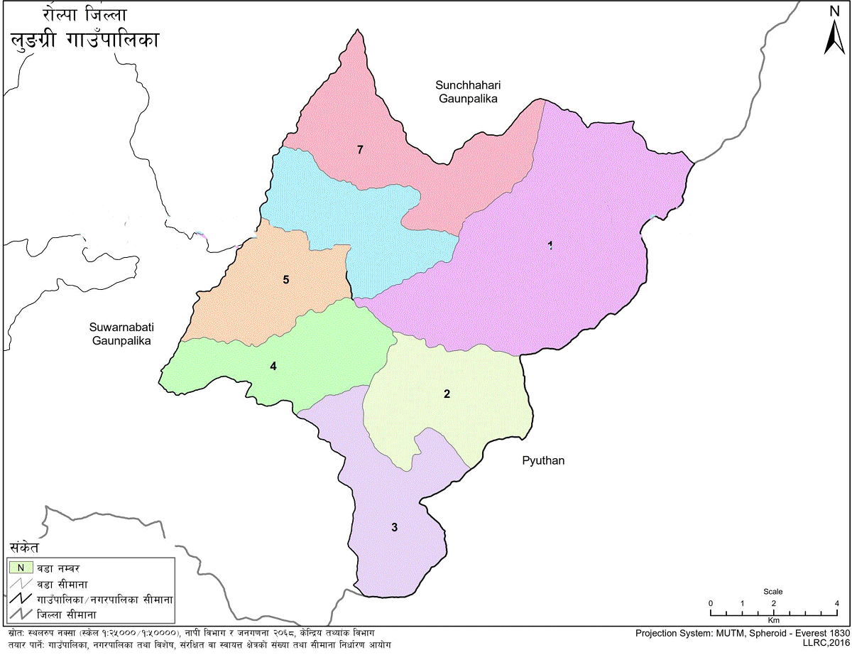
Borders and Boundaries
-
East: Pyuthan District
-
West: Sunil Smriti and Sunchhahari Rural Municipalities
-
North: Sunchhahari Rural Municipality
-
South: Pyuthan and Sunil Smriti Rural Municipalities
Naming of Lugri
Lugri Rural Municipality derives its name from the picturesque Lugri River, which originates from Uwa and Serma of Sunchhahari Rural Municipality. The naming was approved by the local restructuring committee and the Ministry of Local Development on 27 Falgun 2073 BS.
Climate and Geography
Lugri lies at an altitude ranging from 1,000 to 2,000 meters above sea level. The area experiences both warm and cold temperate climates.
-
Temperature Range: -5°C to 32°C
-
Rainfall: Heavy during Shrawan and Bhadra months; cold and frosty during winter months
Costume and Cultural Identity
Though dominated by Magar and Chhetri communities, the residents primarily speak Nepali while adopting many aspects of Magar culture. Traditional dress includes:
-
Men: Traditional Magar hats and waistbands
-
Women: Velvet blouse, “Gunyu,” “Gada,” yellow waistband, green/yellow beads, silver bangles
Demographics and Settlement
The population is mainly comprised of Magar and Chhetri, with minority groups including Bahun, Dashnami, Gurung, and Dalit communities.
Culture, Festivals, and Traditions
Cultural diversity is prominent, with widespread adoption of Magar customs. Common practices include:
-
Forehead Tika: White rice and yogurt by indigenous groups; red tika and symbolic vessels by Chhetri/Brahmin communities during auspicious events
-
Marriage: Predominantly through mutual consent and elopement, with formal family visits after 1–2 years
-
Rituals: Naming ceremonies on the 6th day after birth, 13-day mourning after death
Geographical and Environmental Features
Situated between 900–2,500 meters above sea level, Lugri has diverse vegetation and wildlife supported by rivers and fertile lands.
Main Water Sources:
-
Major River: Jutung Khola, with 13 tributaries
-
Other Streams: Padhera Khola, Panikhola, Lakhurekhola, Ghareli, Khari, Sisnekhola, Sahu, Chilung, Firija
-
Ponds and Water Sources: Lakhuradhara, Bhumethala, Magarthok, Jailepokhari, Amarpani, Simleri, Chadikola, Rangsi Chaki, and others
Natural Resources:
-
Over 450 plant species
-
10 fish species
-
48 bird species
-
5 butterfly types
-
2 reptile species
Land Use and Irrigation
Approximately two-thirds of the land is forested, with only 10% of farmland equipped with irrigation. The rest relies on rainfall.
Administrative Division
Lugri was formed on 23 Falgun 2073 BS by merging five VDCs. It falls under Province Assembly Constituency 'A' of Rolpa District.
Economic and Social Overview
Around 42% of the land is arable, with 80% of residents engaged in agriculture and livestock. Commercial farming practices are growing, and the area shows promise in local enterprise and agro-based industries.
Key Figures:
-
Active Agro-livestock Farms: 20
-
Cottage/Small Industries: 25
-
Shops/Businesses: Approx. 250
-
Stone Quarries: 3
-
Bank Branches: 1 (Nepal Bank Ltd.)
-
Cooperatives: 6
Literacy and Infrastructure
-
Literacy Rate: 57%
-
Schools: 33 community schools (9 secondary, 24 basic level)
-
Health Services: 6 health posts, 1 health unit
-
Water Supply: 83.2% of households have piped water
-
Roads: 188 km built; access to Sulichaur (6 km) facilitates transport
-
Electricity: 70% of households connected to grid; 30% use solar power
-
Cooking Fuel: 95% use firewood; 5% use LPG
Human Development and Poverty
Based on 2014 Human Development Report:
-
HDI (Rolpa): 0.431
-
National Rank: 74 out of 75 districts
-
Life Expectancy: 68.39 years
-
Poverty Rate: 26%
-
Gini Coefficient: 5.62%
These indicators suggest similar socio-economic conditions within Lugri Rural Municipality.
Forests and Biodiversity
Forests cover approximately two-thirds of Lugri's total area, hosting a rich variety of flora and fauna.
Key Non-Timber Products:
-
Medicinal Herbs: Timur, Cinnamon, Cardamom, Satwa, Gurans, Walnut, Tejpatta, Bel
-
Timber and Trees: Pine, Sal, Chilaune, Uttis, Okhar
-
Wildlife: Peacock, Kalij, Red Junglefowl, Deer, Monkey, Rabbit, Danphe, Ghoral, and various birds
Community forests are actively managed and benefit nearly 3,500 households.
Tourism and Green Development
Lugri offers immense potential for eco-tourism due to its clean rivers, biodiversity, and green cover. Local attractions include:
-
Supadeurali
-
Sunchhahari Waterfall
-
Dadagaun
-
Wardachaur Airport
Forests contribute significantly to erosion control and fuel resources. Local furniture industries (18 registered) highlight the economic potential of forest-based products.
Water Sources and Agriculture
Key springs and water systems have helped maintain soil fertility, with potential for expansion in irrigation and conservation. Major springs include:
-
Bhumethala
-
Panikhola
-
Lakhurekhola
-
Amarpani
-
Simleri
-
Chadi Khola
-
Rangsi Chaki
-
Kunapani
-
and others
Greenery and watershed management can play a major role in both environmental balance and local economic development.
Inter-Governmental Collaboration
Effective coordination among federal, provincial, and local governments is necessary to implement sustainable programs in:
-
Land and water conservation
-
Green infrastructure
-
Livelihood improvement through biodiversity-based industries
Schools in Lungri Rural Municipality
Educational Levels
-
Preschools: 36
-
Basic Schools: 35
-
Secondary Schools: 13
-
Plus‑2 (Higher Secondary): 2
Type of Institutions
-
Public Schools: 38
-
Private Schools: 1
-
Total Schools: 39
Secondary and Higher Secondary Schools
-
Baraha Kshetra Secondary School – Badachaur-4, Lungri (Grades 1–12) | Affiliated: National Examinations Board
-
Janajyoti Secondary School – Gajul, Lungri (Grades 1–12) | Affiliated: National Examinations Board
-
Shree Gauri Shankar Secondary School – Thulonamja, Lungri-4 (Nursery–10)
-
Shree Samajik Secondary School – Lungri (Nursery–10)
-
Gokul Secondary School – Lungri (Nursery–9)
-
Shree Secondary School Chhiudar – Chhiudar, Lungri-1 (Nursery–10)
-
Shree Nepal Rastriya Secondary School, Harjang – Harjang, Lungri (Nursery–10)
-
Shree Saraswati Secondary School – Lungri (Nursery–10)
-
Nepal Rastriya Secondary School – Lungri (Nursery–9)
-
Shree Nepal Rastriya Secondary School, Lungri – Lungri (Nursery–10)
Basic Schools
-
Shiva Shakti English Boarding School – Lungri (Nursery–5)
-
Shree Hikmateshwor Basic School – Dulepani Sirpa, Lungri-2 (Nursery–9)
-
Shree Bijayashwari Basic School – Saldanda, Lungri-4 (Nursery–9)
-
Shree Jyoti Basic School – Lungri-6 (Nursery–8)
-
Shree Jyoti Basic School – Sewar, Lungri-5 (Nursery–8)
-
Rastriya Basic School – Lungri (Nursery–7)
-
Shree Yuwabarsa Basic School – Lungri-1 (Nursery–9)
-
Shree Phulbaree Basic School – Harjang, Lungri-7 (Nursery–8)
-
Jana Kalyan Basic School – Pang, Lungri (Nursery–5)
-
Bal Kalyan Basic School – Lungri (Nursery–5)
-
Sishu Kalyan Basic School – Lungri (Nursery–5)
-
Bhumika Basic School – Lungri (Nursery–5)
-
Jana Jyoti Primary School – Lungri-3 (Nursery–5)
-
Janata Basic School – Lungri (Nursery–5)

.jpg)


