


Overview
Madi Rural Municipality (Gaupalika - माडी गाउँपालिका राेल्पा) is one of the ten local levels within Rolpa District, Lumbini Province, in the Federal Democratic Republic of Nepal. Named after the scenic and famous Madi River, its administrative center is located in Ghartigaun. Positioned approximately 27 km northwest of the district headquarters, Liwang, Madi spans an area of 129.05 square kilometers and has a population of 23,464.
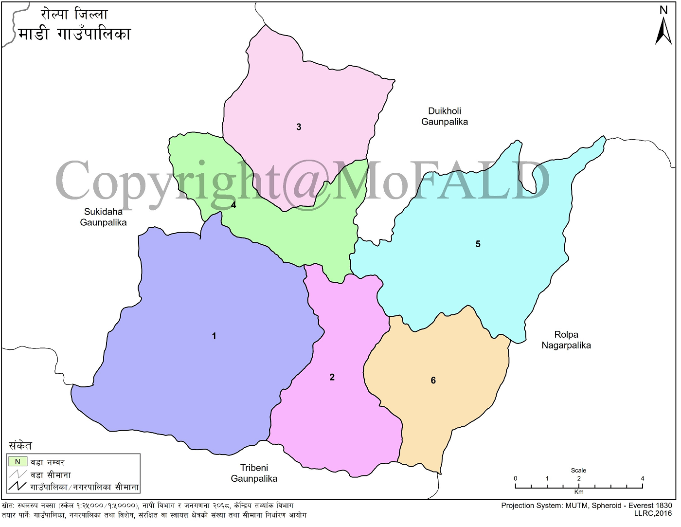
The municipality comprises six wards—Ghartigaun, Ot, Talawang, Bhawang, and Korchawang—formed by merging five former Village Development Committees (VDCs).
It borders Rolpa Municipality to the east, Gangadev Rural Municipality to the west, Paribartan Rural Municipality to the north, and Triveni Rural Municipality and Rolpa Municipality to the south.
Climate and Demographics
Located between 900 to 2700 meters above sea level, Madi experiences a range of climates from warm temperate to cool temperate. The majority of residents belong to the Magar ethnic group, followed by Chhetri, Gurung, and Dalit communities.
The dominant language is Magar Kham, and traditional Magar culture is prominent in local customs and daily life.
Administrative Structure and Ward Distribution
Madi is administratively divided into six wards by consolidating old VDC wards as follows:
-
Ward 1: Ghartigaun (wards 5, 7–9), Ot (wards 3–5)
-
Ward 2: Ghartigaun (wards 1–4, 6)
-
Ward 3: Talawang (wards 3, 5–7)
-
Ward 4: Talawang (wards 1, 2, 4, 8, 9)
-
Ward 5: Bhawang (wards 1–9)
-
Ward 6: Korchawang (wards 1, 2, 6–9)
Geographical Coordinates and Climate Data
-
Latitude: 28°41'03" N
-
Longitude: 80°56'43" E
-
Elevation: 900–2700 meters
-
Temperature:
-
Max: 38.2°C (May–June)
-
Min: 2.2°C (December–January)
-
-
Average Rainfall: 1840 mm
Political and Administrative Division
Madi falls under Constituency No. 1 of Rolpa for provincial and national elections. Each ward includes:
-
Ward 1: Ot
-
Ward 2: Ghartigaun
-
Ward 3 & 4: Talawang
-
Ward 5: Bhawang
-
Ward 6: Korchawang
Land Use and Agriculture
Out of 139.05 sq. km total area:
-
Forests: 97.895 sq. km
-
Settlement: 6.335 sq. km
-
Cultivable Land: 24.82 sq. km
Only 10% of farmland is irrigated, with the rest relying on rainfall. Productive riverbanks contribute to satisfactory yields, although the expansion of settlements is reducing the amount of arable land. Flood-prone areas near rivers are a concern.
Urbanization and Migration
Following the construction of the Martyr’s Highway around 2016, rapid settlement development began. Push factors (poverty) have now shifted toward pull factors (urban opportunity). Despite this, agriculture remains the dominant land use.
Agricultural and Horticultural Products
Grains: Rice, wheat, maize
Cash Crops: Mustard, pea, sugarcane, chickpea, lentil, black gram, turmeric, chili
Fruits: Mango, banana, pear, orange, plum, pomegranate, peach
Vegetables: Gourd, bitter gourd, potato, radish, mustard, cauliflower, leafy greens, okra, brinjal, beans, pumpkin, tomato, cabbage, cucumber, sponge gourd, garlic, onion
Climate and Environment
Madi’s diverse elevation brings climate variation. The Madi River, underground reservoirs, and surface water sources are crucial. The region hosts:
-
110 species of flora
-
10 fish species
-
38 bird species
-
5 butterfly species
-
2 reptile species
Challenges
-
Increasing dependency and interference in forest resources
-
Damage to vegetation from free-grazing livestock
-
Illegal plant harvesting
-
Unplanned settlements and infrastructure development
Major Ponds and Lakes
-
Wange Pond – Ward 1
-
Sunchahara – Ward 4
Major Religious and War Tourism Sites
-
Janamuna Hospital and Bangetal (Ward 1)
-
Paribang Lake, Nawang Siddha Braha (Ward 2) – site of the 6-point peace agreement in 2072 Bhadra
-
Sati Pole Siddha Baba and Martyr Monument, Tharakhola (Wards 3 & 4)
-
Sunachhari – guerrilla arms manufacturing cave (Ward 4)
-
Wanga – site of 11 Maoist artists’ killings; Shiva Temple and guerrilla training ground (Ward 5)
-
Thorpa Lekh (Ward 6) – second highest point in Rolpa; site of armed conflict with Shah forces
Tourism potential is high if these natural, religious, and historical destinations are promoted effectively.
Mining Resources
-
Lead Mine – Bhawang, Ward 5
-
Copper Mine – Bhawang, Ward 5
Festivals
Common festivals include:
-
New Year – Cultural and recreational celebration in Baisakh
-
Raksha Bandhan – Observed in Shrawan–Bhadra
-
Krishna Janmashtami – Lord Krishna’s birthday
-
Teej – Women’s festival, worshipping Shiva and Parvati
-
Dashain – a 15-day Hindu festival, starting Ashwin Shukla Pratipada
-
Tihar – Festival of lights, includes Bhai Tika
-
Nwagi – Harvest festival celebrating new grains
-
Maghe Sankranti – Marks the start of Magh; special for the Magar community
-
Shivaratri – Night dedicated to Lord Shiva
-
Holi – Festival of Colors
Infrastructure
Roads:
-
No blacktop or gravel roads
-
Total of 415 km of earthen roads
Drinking Water:
-
Level 1: Direct use from local sources
-
Level 2: Shared public taps for 10–15 households
-
Level 3: Individual household connections
All three methods are used in Madi depending on the settlement and source distance.
Sanitation:
-
In 2011, 63.5% of households had no toilets
-
By 2017, 94.44% had sanitation facilities
Electricity:
-
In 2011, 0% had electric lighting; 100% used solar
-
In 2017, most wards had solar lighting installed
Communication (2011 Census):
-
Radio: 49.5%
-
TV: 14.2%
-
Cable TV: 2.4%
-
Computer: 0.9%
-
Internet: 0.2%
-
Landline: 1.1%
-
Mobile Phone: 65.6%
Communication has undergone significant expansion due to the adoption of digital technologies, urban growth, and improvements in infrastructure.
School Statistics in Madi Rural Municipality
-
Preschools: 34
-
Basic Schools: 35
-
Secondary Schools: 8
-
Plus‑2 (Higher Secondary): 1
Across the municipality’s educational setup:
-
Public Schools: 33
-
Private Schools: 2
-
Total Schools: 35

.jpg)


