


Overview
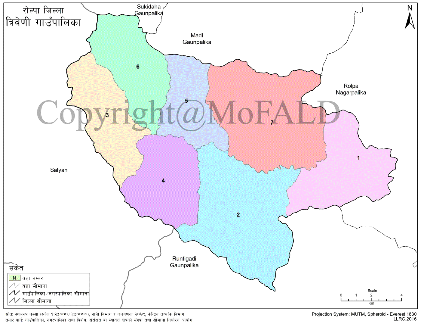
Triveni Rural Municipality (Gupalika -त्रिवेणी गाउँपालिका, राेल्पा), located in Rolpa District of Lumbini Province, was formed by merging five former Village Development Committees: Kareti, Nuwagaun, Budhagaun, Jugar, and Gairigaun. Spread across 205.39 sq. km, the Rolpa Municipality surrounds the rural municipality to the east, Salyan District to the west, Madi and Gangadev Rural Municipalities to the north, and Runtigadhi Rural Municipality to the south.
The area lies between 82°12'52" to 82°35'22" east longitude and 28°12'36" to 28°22'25" north latitude, with elevation ranging from 860 meters to 2800 meters above sea level.
The administrative center is located in Jugar, situated at an altitude of 1,128 meters. Major rivers include the Shivang Khola, Chakri Khola, and Gairi Khola. The municipality comprises 7 wards, with emerging urban areas such as Tila Bazar, Nuwagaun, Dahawan, Nigalpani, Simpani, Lingdung, and Nerpa Bazar.
Population, Culture, and Religion
According to the 2011 census, Triveni Rural Municipality has a population of 25,957. The area is rich in social and cultural diversity, predominantly inhabited by the Magar community, followed by Brahmin, Chhetri, Thakuri, Sanyasi, Kami, Damai, Sarki, and Gharti communities.
Hinduism is the major religion, followed by Buddhism and Christianity. Ethnic and religious harmony prevails. Major festivals include Dashain, Tihar, Janai Purnima, Chandi Purnima, Buddha Jayanti, and Maghe Sankranti. Nepali and Magar are the dominant languages.
Despite the gradual influence of Western culture among youth, traditional attire and customs are being preserved. Cultural expressions include Panche Baja, Kaura, Sorathi, Sarangi dance, Mayur dance, Jhyaure, Balan, and Chudka. Traditional fairs, such as Chapighat Mela and Nerpa Mela, are still celebrated.
Agriculture
Major food crops include rice, wheat, maize, mustard, chickpeas, and lentils. Fruits such as bananas, mangoes, papayas, chilies, guavas, and pears are widely grown. Rice, wheat, and maize are staple crops, while cash crops include mustard, peas, sugarcane, chickpeas, black gram, lentils, chili, and turmeric.
Vegetables cultivated include gourd, bitter gourd, potato, radish, mustard greens, cauliflower, spinach, okra, brinjal, beans, pumpkin, tomato, cabbage, cucumber, sponge gourd, French beans, garlic, and onion.
Each ward has an agricultural and livestock technician. The municipality regularly provides agricultural and livestock subsidies, distributes fruit and vegetable seeds, and offers training on modern and traditional farming techniques. Livestock services include promoting improved animal shelters.
Physical Infrastructure
All wards have road connectivity, with approximately 305 km of earthen roads. Partial graveling has been done in Tila-Jugar-Nigalpani area, and blacktopping is under preparation. The roads in Nuwagaun and Gairigaun along the Shahid Marga are also undergoing initial blacktopping.
Drinking water projects are operational across all wards, benefiting the local population. The “one house, one tap” campaign is being implemented, with plans to extend taps to every household. Of the 4,795 households, 99.13% have access to toilets, reflecting a growing awareness of the importance of hygiene. As of the last fiscal year, around 85% of the population had access to electricity, with expectations to increase coverage this year.
Education
Understanding that development is incomplete without education, formal schooling began in 1954 AD (2011 BS). The education system has been progressively improving. The municipality hosts:
-
1 campus offering bachelor-level programs
-
12 community secondary schools
-
1 institutional secondary school
-
28 community basic schools
-
3 institutional basic schools
Ward No. 6 has achieved 100% school enrollment for children aged 4 to 12.
Health
There are 5 health posts in the municipality, all fully staffed. Female community health volunteers are active in each ward. Health workers conduct outreach in villages. Approved programs include awareness campaigns and health services.
Gender Status
The municipality has a 53.68% female and 46.32% male population. Gender conditions have improved in recent years. Local organizations and municipal policies are contributing to the enforcement of child rights, the reduction of child labor, and the promotion of gender equality. Dedicated programs are included in the annual budget to address gender equity.
Information Technology
Despite being distant from the district headquarters, Triveni Rural Municipality has made notable progress in the IT sector. Out of seven wards, six have access to digital services. Most areas have communication networks, and the municipality is working to extend telephone services in remote areas.
Vital registration and social security distribution are carried out through online and banking systems. To expand digital access, the municipality has introduced mobile apps and local information systems.
Major Religious and Tourist Sites
Ward 2
-
Dhankhani Cave
Ward 3
-
Buddhist Cave
Ward 4
-
Bhuvaneshwari Temple
-
Ghor Dhunga
-
Shiv Temple
-
Gupti Pond
Ward 5
-
Shiva Cave Spiritual Center
-
Gamakot Barahkshetra Site
Ward 6
-
Bagpaile
-
Pokhara Danda
-
Radha Krishna Temple
-
Chulifije (3000 meters)
Ward 7
-
Jai Baba Temple
-
Bhagwati Kalika Temple
-
Chirekhola Shiva Temple
-
Baccha Paila Cave
-
Bhaludula Dumla
-
Dhoreni Tintaale Ananta Cave
-
Thurpa (2221 meters)
-
Gaurimata Temple
Schools in Triveni Rural Municipality
Educational Levels
-
Preschools: 26
-
Basic Schools: 35
-
Secondary Schools: 12
-
Plus‑2 (Higher Secondary): 3
Type of Institutions
-
Public Schools: 36
-
Technical Schools: 2
-
Total Schools: 36
Secondary and Higher Secondary Schools
-
Araniko Secondary School – Nuwagaun, Triveni (Grade 1–12) | Affiliated: NEB, CTEVT
-
Birendra Secondary School – Gairugaun, Triveni (Grade 1–12) | Affiliated: NEB
-
Jan Jagriti Secondary School – Jugar, Triveni (Grade 1–12) | Affiliated: NEB, CTEVT
-
Shree Jana Kalyan Secondary School – Budhagaun, Triveni-4 (Grade 1–10)
-
Shree Shiva Secondary School – Dwarpani, Triveni-2 (Nursery–10)
-
Shree Govinda Secondary School – Dumla, Triveni-7 (Nursery–10)
-
Shree Shukra Secondary School – Jhumlung, Triveni-2 (Nursery–10)
-
Shree Saraswati Secondary School – Lingdung, Triveni-3 (Nursery–10)
-
Shree Bhagawati Secondary School – Dahaban, Triveni-2 (Nursery–10)
-
Shree Saraswati Secondary School – Kaulabot, Triveni-6 (Nursery–10)
-
Shree Balkalyan Secondary School – Yari Kareti, Triveni-1 (Nursery–10)
-
Shree Siddharatna Secondary School – Lek Hanjabang, Triveni-5 (Nursery–10)
Basic Schools
-
Shree Durga Bhawani Basic School – Lamputalichaur, Triveni-4 (Nursery–8)
-
Bal Kalyan Basic School – Western Rukum border (Nursery–8)
-
Shree Balkalyan Model Basic School – Dhoreni, Triveni-7 (Nursery–8)
-
Shree Jayanarayan Basic School – Jagarbot, Triveni-5 (Nursery–8)
-
Shree Janasewa Basic School – Kareti, Triveni-1 (Grade 1–8)
-
Shree Janata Basic School – Hyang Kotban, Triveni-2 (Nursery–8)
-
Shree Saraswati Basic School – Jelbang, Triveni-1 (Nursery–8)
-
Shree Bhanu Basic School – Bajbot, Triveni-6 (Nursery–8)
-
Siddha Basic School – Thaparchaur, Triveni (Grade 1–5)
-
Shree Suryodaya Basic School – Rija, Triveni-6 (Grade 1–8)
-
Nepal Rastriya Basic School – Rampur, Triveni (Nursery–5)
-
Janasharam Basic School – Hundung, Triveni (Nursery–5)

.jpg)


