


Overview
Duduwa Rural Municipality (Gaupalika - डुडुवा गाउँपालिका, बाँके) is one of the eight local levels located in Banke District, Lumbini Province of Nepal, and extends up to the Nepal-India border. Established on Falgun 27, 2073 B.S., this municipality was named after the Duduwa stream. It was formed by merging the previous VDCs of Kamdi, Holiya, Betahani, Bankatti, and Hirminiya (excluding the former Ward No. 7).
Geographically prosperous, naturally rich, and socio-culturally diverse, this municipality is located in the Terai region of Nepal. Narainapur Rural Municipality borders India to the southeast, Rapti-Sonari Rural Municipality to the northeast, Kohalpur Municipality to the north, and Nepalgunj Sub-Metropolitan City to the west.
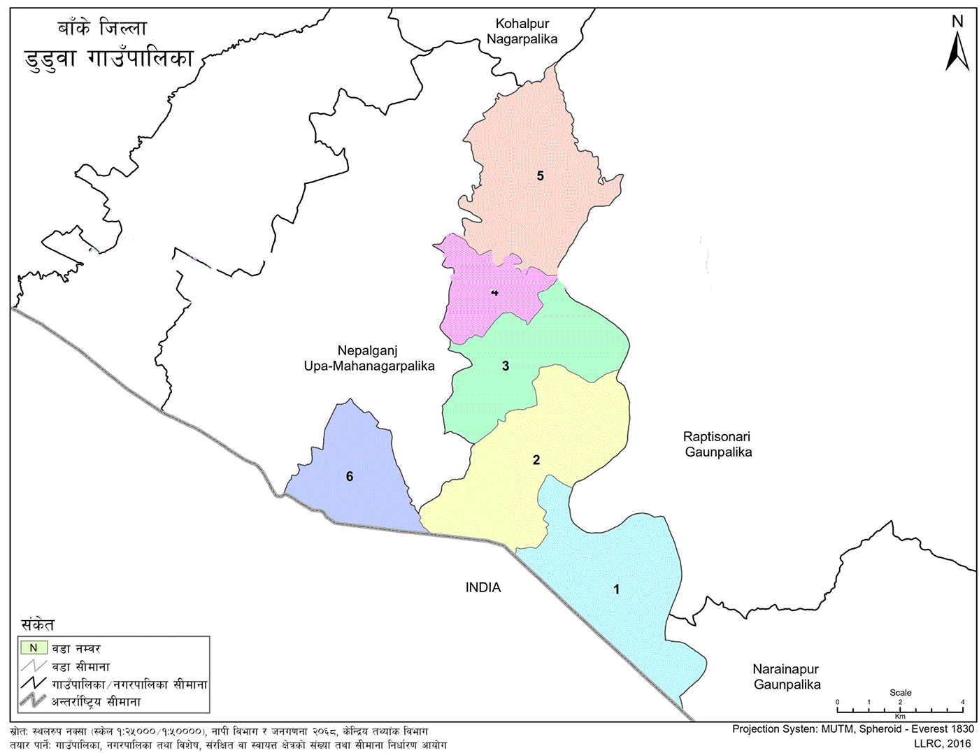
The municipality spans an area of 91.1 square kilometers and comprises six wards. The municipal center is located in Bankatti, Ward No. 3. Ward No. 1 is centered in Holiya, Ward No. 2 in Betahani, Ward No. 4 in Shahpurwa, Ward No. 5 in Kamdi, and Ward No. 6 in Hirminiya.
The total population of this rural municipality is 45,019, comprising 23,623 males and 21,396 females. The population density is 536.55 per square kilometer. The main occupation of the residents is agriculture. Many people also travel to Nepalgunj and Rupaidiha, India, for trade and employment.
This municipality is home to people of multiple faiths, living in harmony. It is regarded as a model of religious unity. It features temples, mosques, and other sacred sites. The Rapti River, Duduwa stream, and community forests are also located within this area.
Geographic Situation
Among the eight local levels of Banke District in Lumbini Province, Duduwa Rural Municipality is situated in the southeastern part of the district, extending up to the Indian border. It spans an area of 91.1 sq. km and is predominantly inhabited by the Madhesi community of the western Terai. Its geography, naming, political condition, natural and cultural significance, and development potential are explained under the following headings.
Duduwa Rural Municipality is located to the east of the district headquarters of Banke. It shares borders with Narainapur and Rapti-Sonari Rural Municipalities to the east, Nepalgunj Sub-Metropolitan City to the west, Bahraich District of India to the south, and Kohalpur and Rapti-Sonari Rural Municipalities to the north. The wards are organized as follows:
-
Ward No. 1: Holiya
-
Ward No. 2: Betahani
-
Ward No. 3: Bankatti
-
Ward No. 4: Kamdi
-
Ward No. 5: Kamdi
-
Ward No. 6: Hirminiya
Table 1: Geographic Composition
-
Ward 1: Holiya (Wards 1–9) – 19.2 sq. km (20.88%)
-
Ward 2: Betahani (Wards 1–9) – 20.29 sq. km (22.27%)
-
Ward 3: Bankatti (Wards 1–9) – 14.49 sq. km (15.91%)
-
Ward 4: Kamdi (Wards 1–6) – 7.08 sq. km (7.77%)
-
Ward 5: Kamdi (Wards 7–9) – 19.68 sq. km (21.6%)
-
Ward 6: Hirminiya (Wards 1–6, 8, 9; excluding Ward 7) – 10.54 sq. km (11.57%)
-
Total Area: 91.1 sq. km (100%)
Source: Ministry of Federal Affairs and General Administration, 2075 B.S.
Historical Identity and Naming
Duduwa Rural Municipality, situated in the western Terai region of Nepal, holds historical, religious, cultural, and natural significance. It was named after the Duduwa stream upon its establishment in Falgun 2073 B.S. The municipality was formed by merging the former Village Development Committees (VDCs) of Kamdi, Bankatti, Holiya, Betahani, and Hirminiya (excluding Ward No. 7).
Political Status
Duduwa Rural Municipality is one of the eight local levels in Banke District under Province No. 5. It consists of 6 wards formed by combining the former VDCs of Kamdi, Bankatti, Holiya, Betahani, and Hirminiya (excluding Ward No. 7).
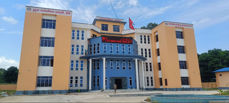
The temporary municipal office is located at the site of the former Bankatti VDC office. Previously part of Bheri Zone in the Mid-Western Development Region of Nepal, this municipality falls under Electoral Constituency "B" for provincial elections and one of four constituencies for federal parliamentary elections.
Land Use
Located in the western Terai, Duduwa features a flat terrain that is ideal for agriculture. Most of the land is arable, with some covered by forests and river channels. Its total area is 91.1 sq. km. It borders the Indian territory to the south and is accessible from the district headquarters by road, making transportation convenient.
Cultural Excellence
This municipality is home to a diverse blend of communities, including Brahmins, Chhetris, Yadavs, Dalits, Muslims, and predominantly hill-origin ethnic groups, primarily in Ward No. 5. The primary spoken language is Awadhi.
The region celebrates a variety of Hindu and Muslim festivals, including Rakshabandhan, Krishna Janmashtami, Ekadashi, Aaitwari, Dashain, Tihar, Maghe Sankranti, Bibaha Panchami, Chaitra Dashain, and Fagu Purnima for Hindus; and Bakr Eid, Tazia, and Mohammad Day for Muslims.
Despite differences in religion and language, the communities live in a spirit of mutual respect. Local customs, rituals, and festivals reflect the cultural richness of the area.
Everyday attire for men includes kurta-pajama, dhoti-kurta, lungi, gamcha, shirt, and pants, while for women, it consists of kurta-suruwal, sari, and dhoti.
Art, Language, and Culture
Local Festivals, Jatras, and Fairs
Major festivals celebrated in Duduwa include Chhath, Kartik Purnima, Tajiya, Dashain, Sawan Puja, Eid, and Bakr Eid. The following is a summary of festivals, locations, timings, and main features:
-
Dashain: At homes and Rapti riverside – Religious
-
Teej: At homes – Religious
-
Moharram: At Karbala – Religious
-
Eid & Bakr Eid: At homes and Eidgah – Religious
-
Bragdaha Baba Mela: Uchhwa Halbaldoli – Religious
-
Ram-Janaki Dhanush Yatra Mela: Bankatti – Religious, Historical
-
Tihar & Deepawali: At homes – Religious
-
Holi: In villages – Religious, Recreational, Historical
-
Sati Ghat Mela: Rapti riverside – Religious, Recreational, Historical
-
Shivaratri: At homes and Bahun Bagiya – Religious, Historical
-
Mohammad Hazrat Baba Mela: Padampur Kamdi – Religious, Historical
-
Maghe Sankranti: At homes and Rapti River – Religious, Historical
-
Chaitra Dashain: At homes – Religious
-
Shab-e-Barat: At homes – Religious
-
Eid-ul-Zuha (Bakr Eid): In villages and Eidgah – Religious
-
Krishna Janmashtami: At homes – Religious, Cultural
Here are the local government services of Duduwa Rural Municipality.

.jpg)


