


Overview
Rapti Sonari Rural Municipality (Gaunpalika - राप्ती साेनारी गाउँपालिका) is situated in the northeastern part of Banke District within Lumbini Province, Nepal. It was established on 27 Falgun 2073 B.S. (corresponding to 10 March 2017 A.D.) following the restructuring of the nation into a federal structure as per the Government of Nepal’s decision. In terms of population, it is the second-largest rural municipality in the country.
According to the 2078 BS National Census, the total population is 67,782, comprising 35,767 females and 32,015 males. The Tharu community predominantly inhabits this municipality, though it also includes people from hill communities, the Madhesi community, and the Muslim community.
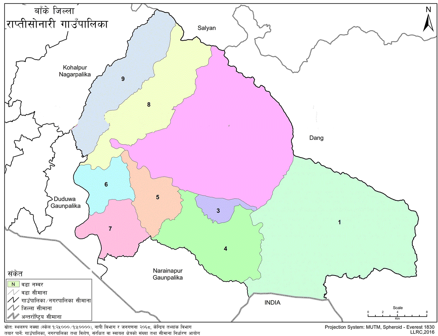
With a total area of 1,041.73 square kilometers, most of its territory falls within Banke National Park. Geographically, it is surrounded by Dang District to the east, Kohalpur Municipality and Duduwa Rural Municipality to the west, Dang and Salyan Districts to the north, and Narainapur Rural Municipality and the Indian border to the south.
It is a valley in itself. Rapti Sonari was formed by merging six former Village Development Committees: Khaskusma, Kachanapur, Baijapur, Binauna, Phattepur, and Mahadevpuri. It is divided into 9 wards.
Population – 67,782
Center – Former Kachanapur VDC Office (Ward No. 2, Agaiya – recently relocated)
Area – 1,041.73 sq. km
Ward Division Based on Former VDCs
-
All wards of Khaskusma VDC
-
All wards of Kachanapur VDC
-
Wards 1, 2, 5, 6 of Baijapur VDC
-
Wards 3, 4, 7, 8, 9 of Baijapur VDC
-
All wards of Binauna VDC
-
Wards 8 and 9 of Phattepur VDC
-
Wards 1 to 7 of Phattepur VDC
-
Wards 6 to 9 of Mahadevpuri VDC
-
Wards 1 to 5 of Mahadevpuri VDC
Geography, Economy, and Social Conditions
Geography
Among the two municipalities and six rural municipalities in Banke District, Rapti Sonari is recognized for its geographical diversity. The municipality stretches approximately 53 kilometers east to west and 14 kilometers north to south. It has the largest area among all local levels in Banke District. Most of its land is covered by forest, while only a small portion is used for agriculture and settlement. The northern part features the Bhawar and Chure mountain ranges and includes parts of Banke National Park, resulting in a sparse population in that region.
The name Rapti Sonari is a combination of two terms: 'Rapti' refers to the Rapti River, which flows southwest after originating from the confluence of the Jhimruk and Madi Rivers in Pyuthan District, and 'Sonari' refers to the lowland region at the base of the Chure Hills traditionally known as the area of the 'Sunar' community.
Bordering Areas:
East – Dang District
West – Kohalpur Municipality and Duduwa Rural Municipality
North – Dang and Salyan Districts
South – Narainapur Rural Municipality and Indian Border
The elevation of Rapti Sonari ranges from 166 meters to 1,236 meters above sea level. It lies between 28°15'00" North Latitude and 81°78'00" East Longitude. The municipality is rich in natural beauty, cultural heritage, and tourism potential.
Geographical Division
-
Flat lands of the Terai region
-
Northern Bhawar region
-
Chure mountain range
The central part of the municipality is traversed by the Rapti River, which flows southwest. Numerous steep streams from the Chure and Bhawar regions merge into the Rapti River. These streams typically flow during the rainy season and are mostly dry in other seasons.
Climate and Weather
Rapti Sonari has a temperate climate. Meteorological records are taken from Khajura and Nepalgunj stations. The average annual rainfall is 1,317 mm. The average minimum temperature is 19°C, and the maximum is 37°C, with a monthly average of 25°C.
Settlements by Ward
Major Settlements by Ward
-
Baksuwa, Badhopur, Bhamka, Baserhi, Chappargauri, Dhippur Tol, Gabar, Gharitol, Haruwa, Khaireni, Khetan Tol, Khokri, Kusum, Lauki, Sauri, Sikta, Siupur, Siupur Tol, Bhagar Tol, Bhavaniyapur
-
Agaiya, Gobarpur, Gurakhola, Hardewa, Kachanapur, Khoriya, Madhuwa, Mathebas, Ovhari
-
Bhainsa, Belaspur, Beldanda, Bhagwatipur, Bhavaniyapur, Galsabas, Narayanpur, Nawalpur, Sano Khaireni, Sinabas, Sisuwa, Thulo Khaireni, Ujyalo Bazar
-
Andharpur, Baijapur, Bantari, Bichka Tol, Buddha Chowk, Kumbhar, Lamidanda, Latania, Narayanpur, Naya Basti, Rajpur
-
Baijapur, Binauna, Latania, Naya Basti
-
Dandatpari, Dhalaiya, Godiyanpur, Habrahwa, Mohanpur, Padnaha, Paneriya, Shantipur
-
Basantpur, Bheluniya, Bishambharpur, Chappar Talliya, Dandatpari, Deupura, Phareda, Gedwa, Nalapari, Bhelauniya, Pahadipur, Piprahwa, Sarra, Sarri, Shantipur, Sismaghari
-
Balapur, Ovhari, Perani
-
Barhabigha, Dangali Tol, Dhakeri, Guruwagawn, Kauwakra, Khairani, Khaireni, Khairi, Lahure Tol, Mahdewa, Perani, Uddain
Economic Conditions
Agriculture and Livestock
Only a small portion of Rapti Sonari’s land is suitable for agriculture. Key crops include paddy, maize, wheat, chickpeas, pigeon peas, lentils, and potatoes. Due to limited irrigation and traditional farming practices, most of the cultivation relies on rainfall. As a result, many farmers are compelled to produce low yields. Only 9.24% (9,582 hectares) of the total area is arable land. With the ongoing development of the Sikta Irrigation Project—one of Nepal’s national pride projects—farmers in the area anticipate significant benefits for their agriculture.
Crop Production Patterns
Two cropping patterns are observed:
-
First: Monsoon (Barse) crops, such as rice and maize.
-
Second: Winter (Hiude) crops including wheat, lentils, potatoes, mustard, pulses, and vegetables.
Agricultural Production Pocket Areas
Based on climate, soil, farmer interest, market conditions, and transportation, the Agricultural Development Office has implemented targeted crop development programs. This area has great potential for agricultural commercialization. Key pocket areas include:
-
Shamsherganj – Vegetables
-
Ward No. 3 – Paddy
-
Bhavaniyapur (Ward No. 3) – Mangoes
-
Phattepur – Designated for maize production this fiscal year
Tourism and Cultural Assets
Tourism Potential
After agriculture, tourism plays a significant role in the local economy. Rich in biodiversity and natural beauty, Rapti Sonari possesses the necessary infrastructure to promote tourism. Attractions include:
-
Banke National Park
-
Varied forests, flora, and fauna
-
Rapti River
-
Sikta Irrigation Dam
-
Lakes such as Kharshe Tal
-
Dhakeri Botanical Garden
-
Public parks, temples, and monasteries
Religious and Cultural Sites
Major Tourist Sites
-
Dhakeri Park (Dhakeri Botanical Garden) – Mahadevpuri, Agaiya
-
Sikta Irrigation Dam and Reservoir
-
Rapti Pakri Suspension Bridge
-
Goshala Temple – Kachanapur
-
Rapti Bridge and Riverbank – Sindhanwa to Phattepur
-
Banke National Park – Mahadevpuri, Kachanapur, Kusum
-
Shiv Temple – Chilaria, Binauna
-
Kanyarat Temple – Binauna
-
Additional Suspension Bridge – Kusum
-
Power House – Baijapur
-
Khair Bhanti Cave – Baijapur
-
Kharshe Lake – Ward No. 1
Major Religious Sites
-
Pokhara Mata Temple – Lalpur, Phattepur
-
Radha Krishna Temple – Rajalla, Fattepur
-
Durga Mata Temple – Koshi Sariyapur
-
Marimata Temple – Sariyapur
-
Shiv Temples – Various wards
-
Kanayaraj Temple – Chachar Farka, Binauna
-
Bhuwar Bhawani Mata Temple – Narayanpur, Baijapur
-
Siddha Sai Kumari Temple – Tikulipur, Kachanapur
-
Goshala Temple – Tikulipur, Kachanapur
-
Other sites – Mahadevpuri, Kusum Bazar
The Khair Bhanti cave, situated in the Sikta forest, is believed by locals to return lost items upon prayer and offering.
Festivals and Cultural Events
Residents observe a variety of festivals based on their religious beliefs. Despite differences in tradition, mutual respect and social harmony prevail. Key festivals include:
Hindu Festivals Dashain, Tihar, Maghi, Holi, Saraswati Puja, Shivaratri, Ram Navami, Nag Panchami, Raksha Bandhan, Krishna Janmashtami, Teej, Rishi Panchami, Kushe Aunsi, Dhuriya Puja, Aitbari (specific to Tharu community)
Muslim Festivals
Muharram, Ramadan, Eid al-Fitr, Eid al-Adha, Namaz
Christian Festivals
Christmas Day, Namaste Day
Local Fairs
-
Pokhara Mata Mela – Lalpur, Phattepur (Month: Mangsir)
-
Marimata Mela – Koshi Sariyapur (Month: Magh)
-
Malangsa Baba Mela – Piprahwa (Month: Falgun)
-
Shivji Mela – Bhavaniyapur (Month: Falgun)
-
Sati Bhawani Mela – Chaitra Dashain
-
Teej Mahotsav Mela – Bhadau
-
Dhakeri Park Festival – Shivaratri
-
Maghi Mela – Bhuwar Bhawani, Baijapur (includes Indian pilgrims)
-
Degree Mela – Tikulipur, Kachanapur
-
Kanyarat Mela – Bairiya, Kusum
-
Goshala Mela (Shivarani) – Binauna
-
Additional Shivaratri Mela – Kusum

.jpg)


