


Overview
Narainapur Rural Municipality (Narainapur Gaupalika) is situated in Banke District, within the Lumbini Province. It spans a total area of 172.34 square kilometers. To the north, it borders Rapti Sonari Rural Municipality; to the south and east, it shares boundaries with India; and to the west, it is adjacent to Duduwa Rural Municipality and also shares a border with India.
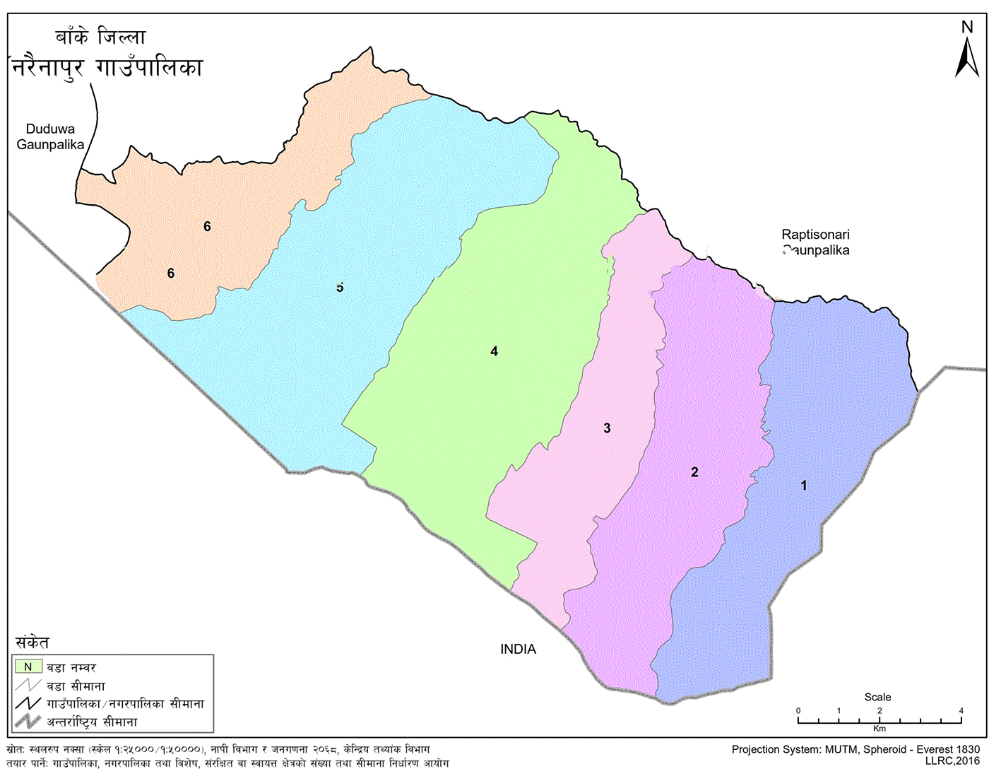
There are six wards in Narainapur: Katkuiya, Laxmanpur, Kalaphata, Narainapur, Matehiya, and Gangapur.
Formation of the Rural Municipality
Narainapur Rural Municipality was established by merging the former Village Development Committees (VDCs): Katkuiya, Laxmanpur, Kalaphata, Narainapur, Matehiya, and Gangapur. These areas now constitute six administrative wards.
To the east, it borders Rapti Sonari Rural Municipality and the Indian border. To the west, it meets Duduwa Rural Municipality and India. It is also bounded by Rapti Sonari in the north and India in the south.
Among the newly formed municipalities and rural municipalities in Banke, Narainapur holds development potential. It is home to a diverse population comprising individuals from various ethnicities and religious backgrounds.
According to the 2011 National Census:
-
Muslim: 15,777 (45.15%)
-
Yadav: 5,595 (16.01%)
-
Chamar/Harijan/Ram: 1,303 (3.73%)
Situated between the plains of the Terai and the Chure region, Narainapur has notable significance in agriculture, trade, natural resources, and social aspects. Agriculture contributes the most to household income. Other major sources include trade, industry, employment, and foreign labor migration.
Residents are gradually shifting from traditional agriculture to modern lifestyles. There is a growing trend among young people to migrate abroad for work and education.
Currently, the municipality has 21 community schools and 16 madrasas, totaling 37 educational institutions. Students from nearby municipalities also come here to pursue their studies.
Due to a lack of electrification in many homes, residents face limited access to electricity. For a long time, the absence of elected representatives and planned development hindered the area's progress.
The municipality is home to multiple communities that celebrate various festivals, including Dashain, Tihar, Eid, Muharram, Bakrid, Ramadan, Buddha Jayanti, and Christmas.
Establishment Process
As per Article 295(3) of the Constitution of Nepal, the Commission for Determination of Number and Boundaries of Rural Municipalities, Municipalities, and Special, Protected, or Autonomous Areas submitted its report on 22 Poush 2073. Based on the report and the Government of Nepal's decision on 22 Magh 2073, a committee under the Federal Affairs and Local Development Ministry submitted its final recommendation on 20 Falgun 2073.
Consequently, on 22 Falgun 2073, Narainapur Rural Municipality was officially established by merging the previously mentioned VDCs.
Wards and Former VDCs
-
Ward 1: Katkuiya (Former Wards 1–9)
-
Ward 2: Laxmanpur (Former Wards 1–9)
-
Ward 3: Kalaphata (Former Wards 1–9)
-
Ward 4: Narainapur (Former Wards 1–9)
-
Ward 5: Matehiya (Former Wards 1–9)
-
Ward 6: Gangapur (Former Wards 1–9)
Source: Ministry of Federal Affairs and Local Development
Geographical Location
Narainapur lies in Banke District under Province No. 5. Geographically, it is situated at the junction of the flat Terai plains and the Chure hills. The coordinates span from 27°51'14" to 27°59'53" north latitude and 81°45'4" to 81°57'43" east longitude.
The elevation ranges from 125 meters to 440 meters above sea level, covering a total area of 172.34 square kilometers.
It is surrounded by:
-
East: Rapti Sonari Rural Municipality and India
-
West: Duduwa Rural Municipality and India
-
North: Rapti Sonari Rural Municipality
-
South: India
Topography
Soil Composition and Fertility
Narainapur is naturally suited for agriculture. Based on current land use:
-
32.48% (55.97 sq. km) is cultivable farmland
-
54.77% (94.39 sq. km) is forested
-
5.48% (9.44 sq. km) is shrubland
-
2.90% (4.99 sq. km) is a sandy area
-
1.69% (2.91 sq. km) is a residential area
-
0.96% (1.66 sq. km) is covered by water bodies
-
1.41% (2.42 sq. km) falls under other uses
Major crops include rice, wheat, maize, black gram, lentils, horse gram, flax, and mustard.
Land Classification
Land classification in Narainapur is based on topography, system types, and susceptibility to soil erosion. The classification also considers land use feasibility and the intensity of erosion.
Soil characteristics and slope gradient are essential indicators for land stability. Most of the terrain in Narainapur is flat, with slopes up to 1 degree.
In some parts of the Chure area to the north, slopes range between 20 to 39 degrees. Due to its overall flat terrain, slope variations across the municipality are minimal.
List of Notable Water Bodies
Rivers and Streams:
-
Kane Khola
-
Simrahana
-
Kala Nala
-
Kunda Nala
-
Rataiya Nala
-
Rapti River (major regional river)
Ponds and Wetlands:
-
Bargadahi Pokhari
-
Bargadahi Reservoir
-
Daulatpur Pokhari
-
Panditpurwa Pokhari
-
Khodama Pokhari
-
Motipur Pokhari
-
Jugun Bhariya Pokhari
-
Newaji Gaun Pokhari
-
Gulariya Gadaha Pokhari
These water bodies are located across multiple wards:
-
Wards 5 and 6: Various rivers and wetlands
-
Ward 3: Local ponds and small streams
-
Ward 4: Year-round water availability
-
Ward 5: Several large ponds
-
Ward 6: Additional reservoirs and wetlands
Religious, Natural, and Touristic Sites
Nepal’s diverse geography, rich biodiversity, and cultural depth have made it a globally recognized tourism destination. Narainapur, with its distinct climatic conditions, diverse plant life, abundant wildlife, and rich cultural heritage, reflects this richness.
Tourism is considered a natural gift and a potential source of economic growth. From pristine rivers and waterfalls to sacred groves, traditional dances, festivals, and community customs, these attractions offer opportunities to promote eco-tourism and heritage tourism.
According to the Tourism Policy 2065, tourism is linked to goals such as:
-
Promoting self-employment
-
Reducing poverty
-
Protecting tangible and intangible heritage
-
Expanding road and air connectivity
-
Sustaining tourism infrastructure development
If fully utilized, Narainapur's cultural and natural resources can make a meaningful contribution to local economic development.
Major Festivals
Narainapur is home to diverse communities with different religions, customs, and attire. The dominant religious groups are Hindu and Muslim. Each group celebrates its own set of festivals and rituals.
Muslim Festivals:
-
Eid
-
Bakra Eid
-
Muharram
-
Ramadan
-
Mohammad Day
Hindu Festivals:
-
Dashain
-
Tihar
-
Ram Navami
-
Mahashivaratri
-
Haritalika Teej
-
Saraswati Puja
-
Krishna Janmashtami
-
Vivaha Panchami
-
Chhath
-
Holi
-
Chaite Dashain
-
Saune and Maghe Sankranti
-
Gai Jatra
-
Matatirtha Aunsi
-
Akshaya Tritiya
-
Harishayani and Haribodhini Ekadashi
-
Nag Panchami
-
Raksha Bandhan (Janai Purnima)
-
Kushe Aunsi
-
Balachaturdashi
-
Kojagrat Purnima
-
Swasthani Brata Katha Purnima
-
New Year
-
Sorha Shraddha
-
Kul Puja
-
Sankat Puja
-
Buddha Jayanti
-
Lhosar (various ethnic groups)
-
Christmas Day
-
Valentine's Day
Culture, Art, Language, and Literature
Narainapur is culturally and artistically rich. It is home to people of various castes, religions, and languages. A majority of the population practices Islam, followed by Hinduism. Indigenous communities also preserve their own languages, customs, and cultural expressions.
During major festivals such as Dashain Mela, Kartik Purnima Mela, and Pannahwa Mela, traditional cultural performances are held, including:
-
Hamka Jodi dance
-
Jhumra dance
-
Phuruwar dance
-
Ramleela theatrical performances
Hindu communities practice Vedic rituals and express mythological stories from the Ramayana, Mahabharata, and Puranas through:
-
Folk songs
-
Duet performances (dohori)
-
Traditional melodies and rhythms
These are deeply tied to local life and values.
However, increasing exposure to mass media and Western influences, combined with a lack of preservation efforts, has led to the decline of many of these traditions. Systematic documentation and promotion of cultural heritage can support both cultural preservation and local development.
Clothing and Social Customs
Narainapur is inhabited mainly by Hindu and Muslim communities, each with their distinct customs, attire, and traditions.
Hindu Traditions:
-
Life rituals include Chhaiti, Naming (Nwaran), Rice Feeding (Pasni), Bratabandha, Marriage, and Funeral rites.
-
Funeral traditions typically involve cremation near riverbanks, except for ascetics, whose bodies are buried.
-
Post-death rituals include Pind Daan, Brahma Daan, and Brahma Bhojan.
-
Some communities still practice traditional healing, shamanism, and spiritual rituals due to lack of formal education.
Muslim Traditions:
-
Upon a child’s birth, the name of Allah is recited in the right ear within minutes.
-
Before feeding, the child’s upper lip is rubbed with soft sugar candy.
-
Amulets are tied on children for protection.
-
Male circumcision is practiced.
-
On the seventh day after birth, a ritual head-shaving and offering to Allah is done.
-
Names are given after these rituals—even stillbirths are named.
-
Burials are practiced for deceased individuals.
Clothing
Since most settlements are located in the Terai region, people typically wear light clothing suitable for warm climates.
Men typically wear:
-
Dhoti, Kurta, Kameez, Vest, Coat, Shirt, Pant, Gamcha (towel), Topi (cap), Lungi
Women commonly wear:
-
Gunyu, Cholo, Blouse, Petticoat, Kurta-Suruwal, Shawls, Scarves, Sari
Muslim women wear:
-
Burqa to cover the face
Younger generations wear:
-
Shirts, Trousers, T-Shirts, Frocks, and other modern outfits
Food Habits
Common foods include:
-
Lentils, Rice, Vegetables, Pickles, Roti, Fish, Meat, Eggs, Milk, Ghee, Yogurt, and Buttermilk
With modernization, beverages like tea, coffee, and soft drinks are also consumed regularly.

.jpg)


