


Overview
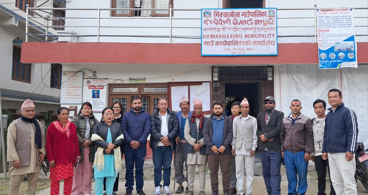
Mikwakhola Rural Municipality is located in the northwestern region of Taplejung District. It was formed through the restructuring of local administrative units under Nepal’s federal governance system. The rural municipality was created by merging four former Village Development Committees (VDCs), making it a diverse region in terms of both ethnicity and culture.
The major ethnic groups residing here include Limbu and Sherpa, followed by Chhetri, Bahun, Khawas, Kami, Rai, Gurung, Sarki, and Damai. Additionally, people from the Sanyasi, Newar, and Tamang communities also live in this area.
The rural municipality is adorned with notable natural and cultural sites such as the scenic Fungfunge Waterfall, the religious Manabhara Devi Temple, Tamor River, Mewakhola, Nyaju Khola, Hadikhola, Sodhu Pokhari, Bhoot Pokhari, Kihne Pokhari, Panch Pokhari, Hans Pokhari, Sun Pokhari, Wagba Pokhari, and Otrak Pokhari. These locations hold both spiritual and tourism value.
This area is home to endangered and rare species such as the red panda, Himalayan black bear, snow leopard, Himalayan monal (danphe), kalij, and the scavenger Bhote crow. The forests here also contain a variety of flora species, including rhododendrons, sunakhari, native herbs, and valuable forest products.
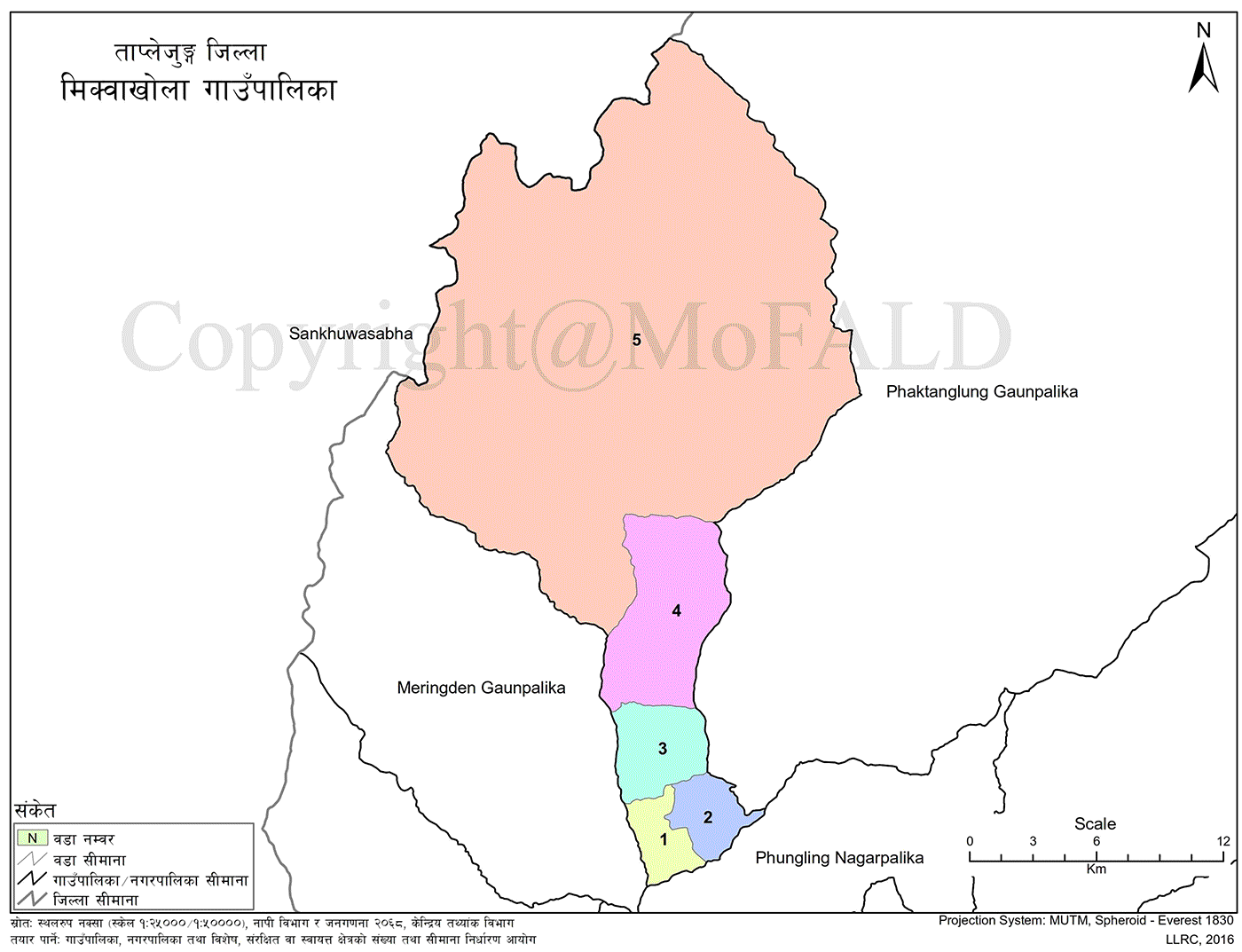
The municipality also hosts natural treasures like Yarsagumba, Panchaunle, Mycopila, Bikhma, Kudki, cardamom, chiraito, and jatamansi. It covers a total area of 442.96 square kilometers and consists of five wards, derived from the former VDCs—Khokling, Liwang, Sawa, and Papung.
Naming and Etymology
Mikwakhola Rural Municipality was named based on a legend connected to the Limbu people of Topkegola in Papung village. A mystical pond, Bhoot Pokhari, was believed to bring misfortune. As a result, people relocated to other areas, but an elderly couple, unable to leave, remained behind. Overwhelmed by loneliness, they cried continuously. Their tears gave birth to a stream, which became known as “Mikwa Bahang” (Tears Stream). Over time, this stream came to be known as Mewakhola.
According to another belief, a demon named Kanayang resided in Sawa village. It demanded a person each day, crying “Kanayang,” which is how it got its name. The stream that ran through this area was later named after the municipality to preserve the memory of that legend.
There is also a story of a young man from Mikwakhola who brought a Sherpa girl from Tibet. When her family found out, they stopped the couple in their tracks. The young man, heartbroken, shed tears which turned into a stream, known as “Mikwa” in Limbu. In honor of these historical and cultural narratives, the name Mikwakhola Rural Municipality was established.
Geographic Features and Boundaries
Mikwakhola covers approximately 12% of the landmass of Taplejung District. Of the district’s total area of 3,646 sq. km, Mikwakhola occupies 442.96 sq. km, making it the third-largest rural municipality after Phaktanglung and Sirijanga.
It lies between 27°38' to 27°73' North latitude and 87°50' to 87°73' East longitude, ranging from 800 meters to 5,400 meters above sea level. It primarily faces the southwest.
Borders:
-
East: Phaktanglung Rural Municipality
-
West: Meringden Rural Municipality
-
South: Tamor River and Phungling Municipality
-
North: Sankhuwasabha District and the Tibet Autonomous Region of China
Land Features
Mikwakhola features diverse landforms ranging from 800 to 5,500 meters in elevation. The terrain includes mountains, large hills, river valleys, cliffs, rocky zones, and fertile plains. The area features various rivers and streams that are suitable for irrigation, making it highly favorable for agriculture.
Although the land is fertile, traditional crops such as maize, millet, barley, and wheat continue to dominate. There is limited focus on modern cash crops and seasonal produce. The open meadows are well-suited for livestock, including yaks, cows, buffaloes, sheep, and goats.
The region encompasses the Himalayan, high hill, and mid-hill zones. Rivers and streams generally flow from north to south and east to west. Due to its diverse topography, the region hosts a wide variety of vegetation and biodiversity.
Climatic Zones:
-
Himalayan
-
Cool Temperate
-
Subtropical
-
Tundra (in higher regions)
These variations support a range of agricultural ventures and ecological conservation efforts.
Natural and Cultural Heritage
Mikwakhola is blessed with scenic waterfalls and numerous ponds. The continuously flowing Nyaju Khola, Godhumas Khola, and Hadikhola are significant water sources. The sacred Manabhara Temple and several Buddhist monasteries add cultural value to the region.
Notable Natural and Cultural Sites:
-
Fungfunge Waterfall
-
Bhoot Pokhari
-
Sodhu Pokhari
-
Panch Pokhari
-
Manabhara Devi Temple
-
Nyaju Khola
-
Mewakhola
-
Various Buddhist Monasteries
These landmarks contribute to the region’s ecological, religious, and historical significance.
Fungfunge Waterfall
Located in Ward No. 4 of the former Sawa VDC, now part of Mikwakhola Rural Municipality, Fungfunge Waterfall flows continuously as a natural blessing. Its breathtaking natural beauty captivates visitors and carries both religious and tourism value. Though its exact height has not been officially recorded, it is believed to fall from a cliff over 300 meters high. At the base of the fall lies a shrine dedicated to the goddess Fungfunge Devi.
Locals worship this waterfall as a deity and believe misfortunes occur if it is not honored. Despite its spiritual significance, it remains relatively unknown among external tourists due to the lack of access roads and accommodation. Compared to the 359-meter Hyatung Waterfall of Tehrathum—which dries up in winter—Fungfunge flows powerfully year-round, making it a potential highlight of the region if promoted and developed with infrastructure.
Sodhu Pokhari
Sodhu Pokhari lies in Ward No. 5 of the former Papung VDC, in the northwest part of the municipality. It is a sacred and scenic pond situated roughly 30 minutes uphill from Tokpegola village. The pond is surrounded by grassy meadows and lush green forests of gobresalla (juniper trees), with a small island in the center housing a temple dedicated to the local deity Chhode Gyabu.
The Thukpachesi festival of Tokpegola is celebrated at this temple. Known as Chhayode in the local language, Sodhu Pokhari is near the borders of Phaktanglung, Sankhuwasabha, Tibet, and Meringden. With 216 households in the area, this site is a confluence of cultural, religious, and ecological diversity. Among the 300+ glacial lakes of Taplejung, 52—including Sodhu, Bhoot, Tin Pokhari, Sajupokhari, Banduke Pokhari, and Panch Pokhari—are found in this region.
Bhoot Pokhari
Situated in Ward No. 1 of the former Papung VDC, Bhoot Pokhari is known for its eerie aura. Surrounded by dense forests, the pond is about 150 meters long and wide. According to folklore, people who visit in the early morning or evening experience optical illusions, making the pond appear invisible or drawing them in mysteriously. Despite its ominous legend, it now attracts worshippers and curious visitors.
Tin Pokhari
Located about two hours east of Tokpegola, this area features three large ponds in close proximity—hence the name Tin Pokhari. Though the area has around 10–11 ponds, the largest three have lent their name to the region. Locals refer to them as Jetho (eldest), Mailo (middle), and Kanchho (youngest) Pokhari.
Sajupokhari
Situated southwest of Tokpegola in the Sajudanda valley, this elongated, dark-blue pond lies beside a trekking trail that connects Basantapur, Gufapokhari, Jaljala Himal, and Tokpegola. Other nearby ponds include Shiva Jhari, Lumbasamba, Banduke, Lungjung-Rate, Jorpokhari, and Sabha Pokhari.
Thangla Pokhari
This pond is found atop the Thangla Bhanjyang pass, on the trail from Tokpegola to Tibet. Surrounded by rocky cliffs, the pond appears peaceful and blue, attracting trekkers heading northward.
Manabhara and Wagba Pokhari
Located between former Sawa VDC and Khejenim, Manabhara is a religious site with shrines for goddesses Rakta Kali and Vaishnavi Devi. Nearby lies the picturesque Wagba Pokhari. Worshippers visiting Manabhara often use its water for rituals. Despite being hidden in the forest, the pond remains clean year-round, thanks to birds that remove debris. The water is believed to have medicinal properties due to the surrounding herbs.
Thonkpa Fukku Cave
This large cave lies in Ward No. 2 of the former Sawa VDC. In ancient times, before burial customs, bodies were placed in this cave. Remains of human bones can still be found inside. During a pre-unification war between warriors of Mewakhola—Samyang, Singyang, Hinahang, and Perihang—many fighters perished due to food and water shortages. One such warrior, Tangdappa Sawa, is believed to have taken refuge and died in this cave.
Mewa Khola
This river flows continuously through the center of the village from the upper Himalayas. In its lower course, it marks the boundary with Meringden Rural Municipality. Mewa Khola holds vast potential for hydropower development, with plans underway for a 101 MW Tamor Mewa project. Proper management could transform this river into an energy and tourism resource.
Local Festivals and Cultural Events
Mikwakhola hosts diverse festivals reflecting its ethnic and cultural plurality. Major groups include Limbu (81% of the population), Sherpa, Bahun-Chhetri, Dalit, and others. Celebrations span Limbu rituals, Hindu festivals, and Christmas, including:
-
Chasok Tongnam
-
Kakfekwa Tongnam
-
Balihang Tongnam
-
Dashain, Tihar, Teej
-
Ram Navami, Shivaratri
-
Maghe Sankranti, Kushe Aunsi
-
Udyouli, Ubhauli, Buddha Purnima
-
Dyungne, Thukpachesi, Futuk, Gyaso
-
Lhosar (Sherpa, Gurung, Tamang communities)
Traditional dances include:
-
Dhan Nach, Hakpare (Limbu)
-
Syabru, Walung, Dhokpya, Dhunjang (Sherpa)
-
Sakela/Chandi Nach (Rai)
Limbu attire features Tagaa, Mekhli, Samyangphung, and traditional jewelry. Sherpas wear Bakkhu, Docha, Angi, Pangden, and Keten.
Key Tourist Attractions
Major Sites by Ward
-
Ward 2: Bagthala – Scenic Area
-
Ward 4: Fungfunge Waterfall – Religious and Natural Attraction
-
Ward 5: Sodhu Pokhari, Bhoot Pokhari, Sun Pokhari, Kalopokhari, Kuhine Pokhari, Hans Pokhari, Goru Jure Pokhari, Bhusbhuse Pokhari, Misi Pokhari, Ramphule Pokhari, Panch Pokhari, Lamidanda Pokhari, Tin Pokhari, Dabla Pokhari, Bhauso Pokhari – Religious and Cultural Significance
-
Ward 4: Wagba Pokhari, Otrak Pokhari, Fungfunge Temple, Tashi Chholing Gompa, Tashi Chhyakar Gompa
-
Ward 5: Tashi Chholing Gompa, Sangyawing Gompa, Lapse Gompa
-
Ward 4: Foktanglung Temple
-
Ward 3: Manghim
List of Schools in Mikwakhola Rural Municipality
-
Pre-schools: 25
-
Basic Level Schools (Grades 1–8 or Nursery–8/10): 28
-
Secondary Level Schools (Up to Grade 10): 4
-
Plus-Two (Grade 11–12): 2
-
Total Schools: 28
-
Public Schools: 28
Plus-Two Level Schools (Grade 1–12)
-
Sanwa Secondary School
Location: Sanwa, Mikwakhola
Affiliation: National Examinations Board
Grades: 1 – 12 -
Moti Secondary School
Location: Khokling, Mikwakhola
Affiliation: National Examinations Board
Grades: 1 – 12
Secondary Level Schools (Up to Grade 10)
-
Pancheshwari Secondary School
Location: Liwang, Mikwakhola -Grades: Nursery – 10 -
Balden Secondary School
Location: Mikwakhola
Grades: 1 – 10
Basic Level Schools (Nursery to Grade 8/10)
-
Shree Singheshwaree Basic School – Nursery – 8
-
Ojha Gaun Basic School – Nursery – 6
-
Besigau Basic School – Nursery – 8
-
Sherpa Basic School – Nursery – 5
-
Killing Basic School – Nursery – 6
-
Phungphunge Basic School – Nursery – 5
-
Sagarmatha Basic School – Nursery – 6
-
Kanchanjangha Basic School – Nursery – 5
-
Chinabung Basic School – Nursery – 5
-
Janata Basic School – Nursery – 5
-
Shree Wairakhu Basic School – Nursery – 5
-
Simbuk Basic School – Nursery – 5
-
Rajeshwori Basic School – Nursery – 5
-
Handrung Basic School – Nursery – 5
-
Manabhara Basic School – Nursery – 5
-
Saraswati Basic School – Nursery – 5
-
Sunkhani Basic School – Nursery – 5
-
Jana Ratri Basic School – Nursery – 5
-
Nawa Jyoti Basic School – Nursery – 3
-
Madan Basic School – Nursery – 5
-
Tiljung Basic School – Nursery – 2
-
Bhirgaun Basic School – Nursery – 5
-
Andheri Basic School – Nursery – 3
-
Janamukhi Basic School – Nursery – 2

.jpg)


