


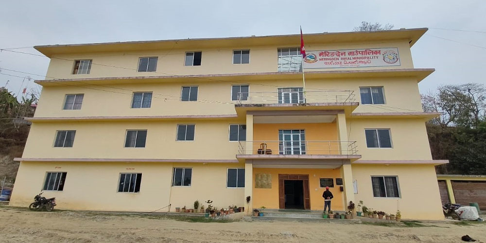
Overview
Meringden Rural Municipality (Gaupalika - मेरिङदेन गाउँपालिका, ताप्लेजुङ) is a picturesque local unit situated in the northwestern part of Taplejung District, under Koshi Province in eastern Nepal. It was established in 2073 B.S. when the Government of Nepal implemented 744 local levels through the Ministry of Federal Affairs and Local Development.
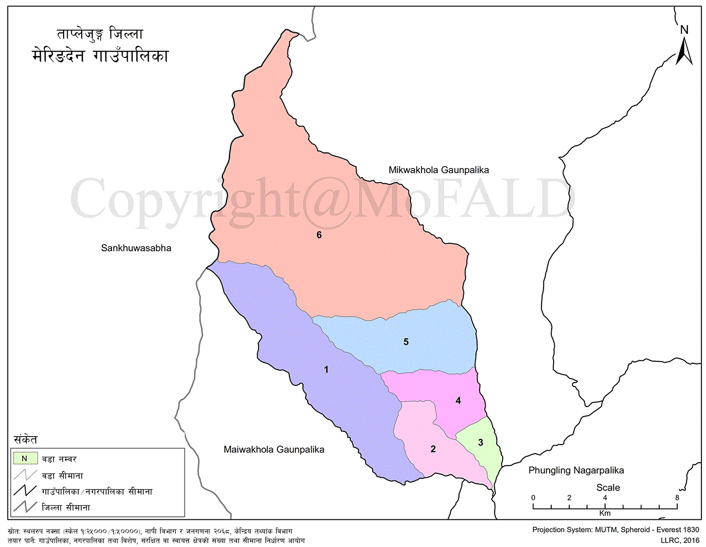
This rural municipality was formed by merging the former Village Development Committees (VDCs) of Thinglabu, Santhakra, Khamlung, Lingtep, Thukima, and Nalbu. The name “Meringden” originates from the Limbu language, where “Mering” means suffering or pain, and “Den” means a place.
Meringden is predominantly inhabited by the Limbu community, reflecting its cultural identity through its name and heritage.
Geographic Boundaries
Meringden Rural Municipality shares its borders with the following:
-
East: Phungling Municipality and Mikwa Khola Rural Municipality
-
West: Sankhuwasabha District
-
North: Mikwa Khola Rural Municipality
-
South: Maiwa Khola Rural Municipality
Area and Population
-
Total Area: 210.33 square kilometers
-
Total Households: 2,662
-
Total Population: 11,838
-
Female Population: 5,979
-
Male Population: 5,859
-
Administrative Division
Meringden Rural Municipality is administratively divided into six wards. Each ward comprises the former entire VDC area as listed below:
-
Ward 1: Entire Thinglabu VDC (Wards 1–9)
-
Ward 2: Entire Santhakra VDC (Wards 1–9)
-
Ward 3: Entire Khamlung VDC (Wards 1–9)
-
Ward 4: Entire Lingtep VDC (Wards 1–9)
-
Ward 5: Entire Thukima VDC (Wards 1–9)
-
Ward 6: Entire Nalbu VDC (Wards 1–9)
This structured division ensures administrative clarity and community representation across all areas merged under the municipality.
List of Schools in Meringden Rural Municipality
-
Pre-schools: 27
-
Basic Schools: 36
-
Secondary Schools: 7
-
Plus-2 Level Schools: 2
-
Public Schools: 36
-
Total Schools: 36
Pre-Schools (Nursery Level)
-
Changa Primary School – (Nursery–5) – Meringden
-
Devi Basic School – (Nursery–5) – Meringden
-
Jalpa Devi Basic School – (Nursery–8) – Meringden
-
Janata Basic School – (Nursery–5) – Meringden
-
Jana Jyoti Basic School – (Nursery–5) – Meringden
-
Kanaka Basic School – (Nursery–8) – Meringden
-
Krishna Basic School – (Nursery–5) – Meringden
-
Laxmi Secondary School – (Nursery–10) – Meringden
-
Mahendra Basic School – (Nursery–8) – Meringden
-
Nalbu Basic School – (Nursery–8) – Meringden
-
Nawa Jyoti Basic School – (Nursery–3) – Meringden
-
Okhrabu Basic School – (Nursery–1) – Meringden
-
Pandolung Secondary School – (Nursery–10) – Nalbu
-
Pokhari Basic School – (Nursery–3) – Meringden
-
Pragatishil Basic School – (Nursery–4) – Meringden
-
Sambabung Basic School – (Nursery–4) – Meringden
-
Samathalung Basic School – (Nursery–5) – Meringden
-
Santhakra Basic School – (Nursery–8) – Meringden
-
Simle Basic School – (Nursery–5) – Meringden
-
Sindhakali Basic School – (Nursery–8) – Meringden
-
Singha Devi Basic School – (Nursery–1) – Meringden
-
Suryadevi Secondary School – (Nursery–10) – Meringden
-
Surke Secondary School – (Nursery–10) – Meringden
-
Sumsolok Basic School – (Nursery–5) – Meringden
Basic Schools (Grade 1 to 8)
-
Chandi Danda Basic School – (1–4) – Meringden
-
Jaljale Primary School – (1–3) – Meringden
-
Rajarani Basic School – (1–5) – Meringden
-
Sangjim Basic School – (1–5) – Meringden
-
Shrijanga Primary School – (Nursery–5) – Meringden
-
Sinthalung Basic School – (1–3) – Meringden
-
Wardumba Primary School – (1–4) – Meringden
Note: Many schools listed under pre-school also offer classes up to grade 5 or 8 and function as basic schools.
Secondary Schools (Up to Grade 10)
-
Pandolung Secondary School – (Nursery–10) – Nalbu
-
Surya Devi Secondary School – (Nursery–10) – Meringden
-
Surke Secondary School – (Nursery–10) – Meringden
-
Laxmi Secondary School – (Nursery–10) – Meringden
-
Singhakali Secondary School – (1–10) – Meringden
-
Singha Devi Basic School – (1–8, functions as lower secondary) – Meringden
Plus-2 Schools (Grade 11–12)
-
Prithivi Secondary School – (1–12) – Khamlung – NEB
-
Tribhuvan Secondary School – (PG–12) – Mewakhola Thukima – NEB

.jpg)


