Sanni Triveni Rural Municipality (सान्नी त्रिवेणी गाउँपालिका) is a rural municipality in Kalikot District, Karnali Province, Nepal. Its administrative centre is located at Mehalmudi. The municipality has 9 wards and covers 136.71 square kilometres. It was formed under Nepal’s local-level restructuring from the former Mumra, Mehalmudi, and Raku Village Development Committees. The local level was declared in the Nepal Gazette on 2073/11/27 BS and was upgraded as Sanni Triveni Rural Municipality from 2074/06/01 BS.
| Indicator | Figure |
|---|---|
| Name | Sanni Triveni Rural Municipality |
| Nepali Name | सान्नी त्रिवेणी गाउँपालिका |
| District | Kalikot |
| Province | Karnali Province |
| Administrative Centre | Mehalmudi |
| Total Area | 136.71 sq. km |
| Total Population | 13,491 |
| Male Population | 6,588 |
| Female Population | 6,903 |
| Total Households | 2,422 |
| Number of Wards | 9 |
| Population Density | About 99 people per sq. km |
| Altitude | About 1,591 metres / 5,218.48 feet |
| Distance from Kathmandu | About 754 kilometres |
Sanni Triveni Rural Municipality was formed under Nepal’s local-level restructuring. The local level was declared in the Nepal Gazette on 2073/11/27 BS and was upgraded as Sanni Triveni Rural Municipality from 2074/06/01 BS.
The municipality was formed from the former Mumra, Mehalmudi, and Raku Village Development Committees. Its administrative centre is located at Mehalmudi.
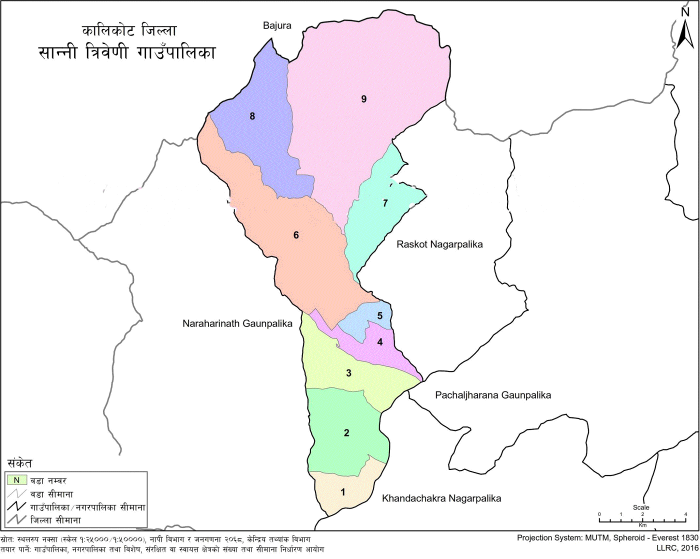
Sanni Triveni Rural Municipality (Gaupalika) lies in Kalikot District of Karnali Province. It covers 136.71 square kilometres and is located about 754 kilometres from Kathmandu.
The municipality is bordered by Raskot Municipality on the East, Narharinath Rural Municipality on the West, Bajura District to the North, and Khandachakra Municipality to the South.
Sanni Triveni Rural Municipality has 9 wards. These wards are the local administrative divisions of the municipality.
Sanni Triveni Rural Municipality has a total population of 13,491. The population includes 6,588 males and 6,903 females.
The municipality has 2,422 households. Based on the population and area figures, the population density is about 99 people per square kilometre.
| Indicator | Figure |
|---|---|
| Total Area | 136.71 sq. km |
| Total Population | 13,491 |
| Male Population | 6,588 |
| Female Population | 6,903 |
| Total Households | 2,422 |
| Number of Wards | 9 |
| Population Density | About 99 people per sq. km |
The population density is calculated from the population and area figures: 13,491 divided by 136.71 equals about 98.68 people per square kilometre, rounded to 99.
Sanni Triveni Rural Municipality lies at an altitude of about 1,591 metres, or 5,218.48 feet, above sea level.
The local temperature range is about 35°C maximum and -8°C minimum.
Major festivals observed in Sanni Triveni Rural Municipality include Dashain, Tihar, Holi, Maghe Sankranti, Krishna Janmashtami, Buddha Jayanti, Haritalika Teej, Shivaratri, and Paith festival.
Sanni Triveni Rural Municipality is located in Kalikot District, Karnali Province, Nepal.
The administrative centre of Sanni Triveni Rural Municipality is Mehalmudi.
Sanni Triveni Rural Municipality has 9 wards.
Sanni Triveni Rural Municipality covers 136.71 square kilometres.
Sanni Triveni Rural Municipality has a total population of 13,491, including 6,588 males and 6,903 females.
Sanni Triveni Rural Municipality has 2,422 households.
Sanni Triveni Rural Municipality was formed from the former Mumra, Mehalmudi, and Raku Village Development Committees.
Sanni Triveni Rural Municipality is bordered by Raskot Municipality to the east, Narharinath Rural Municipality to the west, Triveni Rural Municipality of Bajura District to the north, and Khandachakra Municipality to the south.


.jpg)