


Overview
Sunchhahari Rural Municipality (Gaupalika - सुनछहरी गाउँपालिका) is one of the ten local levels within Rolpa District, located in Lumbini Province of the federal democratic republic of Nepal. Shaped like a butterfly or damaru, the rural municipality lies 48 km northeast of the district headquarters, Liwang. Formed by merging the former VDCs of Seram, Gam (Inner/Outer), Syuri, Jaimakasala, Phagam, and Jelbang, it spans an area of 277.62 sq. km.
This document outlines the geographical, political, social, natural, and cultural characteristics of the area, including development prospects under the following sub-headings.
Geographical Location
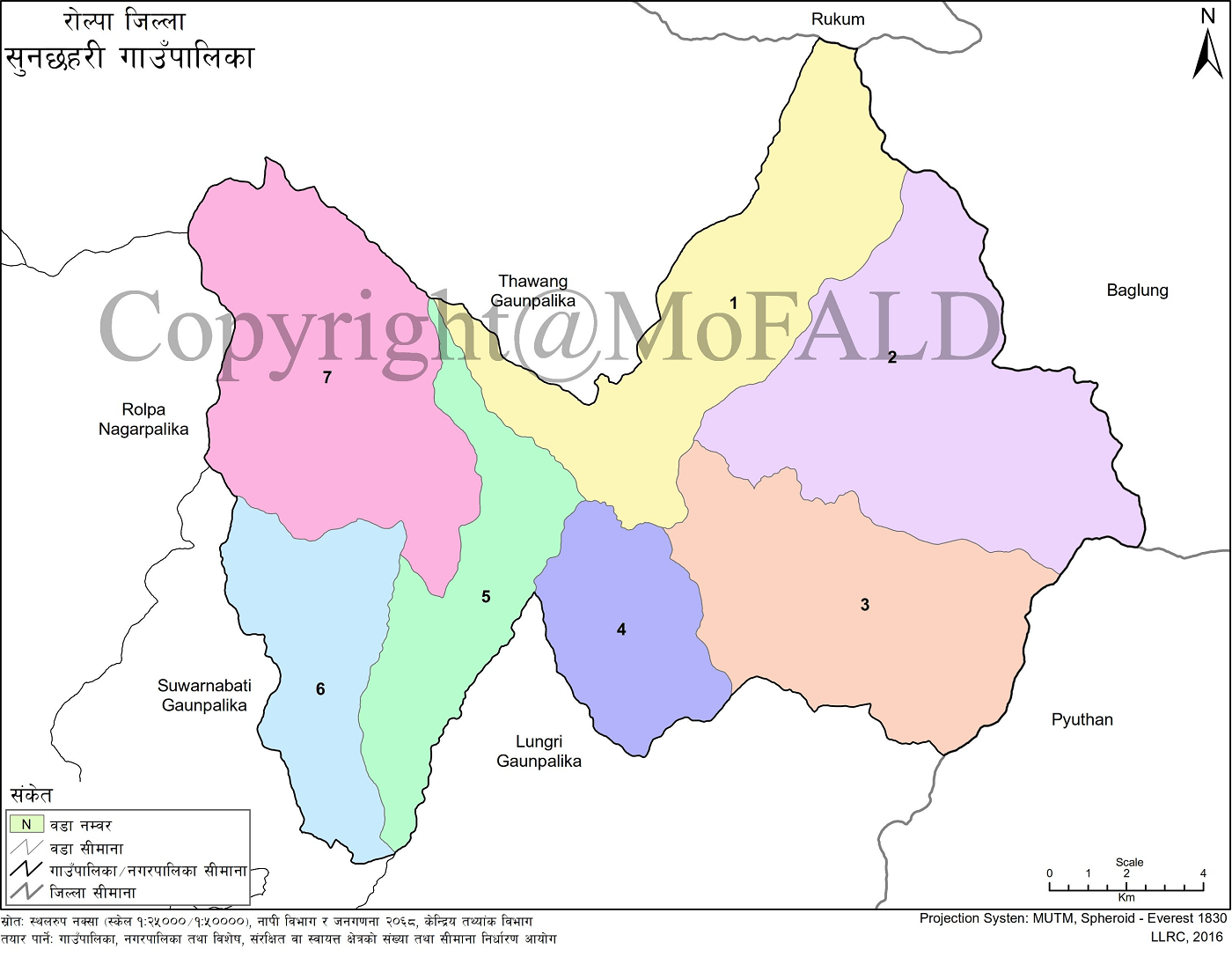
Sunchhahari lies between 900 meters to 3,500 meters above sea level and is located between latitudes 28°10'31" N to 28°22'40" N and longitudes 82°36'57" E to 82°48'03" E. The rural municipality is administratively divided into 7 wards. It is accessible from Bhalubang via the East-West Highway by covering 70 km along the Bhalubang-Rolpa road, followed by 4 km of rough road from Sulichaur to Phuliban.
Geographically, it borders Baglung and Pyuthan to the east, Rolpa Municipality and Sunil Smriti RM to the west, Thawang RM and Rukum to the north, and Lungri RM to the south. The administrative center is located in Powang, Ward No. 5, named after the famous Sunchhahari Waterfall.
General Information
-
Name: Sunchhahari Rural Municipality
-
Incorporated Former VDCs: Seram, Gam, Syuri, Jaimakasala, Phagam (Wards 2–9), Jelbang
-
Total Area: 277.62 sq. km
-
Population: 16,034
-
Administrative Center: Powang, Rolpa
-
Ward Count: 7
Bordering Regions:
-
East: Baglung and Pyuthan Districts
-
North: Thawang RM and Rukum District
-
West: Rolpa Municipality and Sunil Smriti RM
-
South: Lungri RM
Ward-wise Population and Households
-
Ward 1 (Seram): 374 households, 1,972 population (12.30%)
-
Ward 2 (Inner Gam): 383 households, 2,012 population (12.55%)
-
Ward 3 (Outer Gam): 404 households, 1,994 population (12.44%)
-
Ward 4 (Syuri): 319 households, 1,720 population (10.73%)
-
Ward 5 (Jaimakasala): 580 households, 3,020 population (18.83%)
-
Ward 6 (Phagam): 446 households, 2,420 population (15.09%)
-
Ward 7 (Jelbang): 510 households, 2,896 population (18.06%)
-
Total: 3,016 households, 16,034 total population
Historical Background and Naming
Situated in the northeastern region of Rolpa, Sunchhahari spans 277.62 sq. km. The area has a proud and resilient history. It was established in 2073 BS after restructuring the former VDCs. Villages like Gam and Jelbang played critical roles during Nepal’s ten-year civil conflict, and the municipality represents a culturally rich Magar-dominated region.
Sunchhahari’s identity stems from trust, community unity, integrity, hard work, and a commitment to prosperity. With a strong base in indigenous Magar culture, the municipality shows potential in herbal farming, animal husbandry, mining, and hydropower utilization.
Political Structure
Sunchhahari RM is located in Rolpa District, Province No. 5, formed by merging several VDCs. Politically divided into 7 wards, the municipality has its center in Powang, the geographic midpoint of the former Jaimakasala VDC. It falls under Provincial Constituency 'A' for Province Assembly elections.
Topography
This high and mid-hill terrain is largely mountainous and steep with limited flatlands. Settlements are often clustered but surrounded by steep and forested hills, with small valleys carved by streams. Most land is sloped, and usable flat agricultural land is scarce.
Natural Resources
Key natural sites include the Sunchhahari Waterfall, Kothibhir, Gongbang battlefield, Vibang Lake, Tilachan Lake, Jelbang’s military sites, and mineral resources like iron and gold. Agriculture covers 49.49%, forests 38.76%, shrublands 10.85%, grasslands 0.56%, water bodies 0.27%, and open areas 0.07% of total land.
Major rivers: Lungri, Phagam, and Gajul—though irrigation use remains limited.
Cultural Features
This rural municipality reflects a blend of Magar and Khas traditions, with Hindu-Buddhist influence. Over 70% of residents are Magar, followed by Chhetri, Brahmin, Dalit, and Sanyasi groups. Nepali is the primary working language, with Magar and Kham spoken locally. Festivals include Krishna Ashtami, Teej, Janai Purnima, Dashain, Tihar, Maghe Sankranti, and Chaitedashain.
Religious events and community fairs include:
-
Brahma Puja (3 times annually) in Jaljala
-
Bhadure Puja, Jethasi Mela, Mangshire Mela, Lung Mela, Maghe Mela, Kul Baraha Mela, and Bhume Puja
Common attire includes daura suruwal and topi for men, and gunyu cholo or kurta suruwal for women.
Development Prospects
Key opportunities for development include:
-
Improved Animal Husbandry: Upgrade local breeds to improve dairy and meat products.
-
Commercial Vegetable Farming: Promote climate-appropriate organic and seasonal farming in river-adjacent lands.
-
Fruit Cultivation: Encourage farming of oranges, lemons, pears, bananas, mangoes, kiwis, walnuts, and more.
-
Herbal Farming: Utilize local herbs like timur, jatamasi, amla, rittha, and chiraito for commercial use.
-
Road Access and Market Linkage: Enhance year-round road access and connect to trade centers.
-
Mineral Exploration: Develop iron, copper, lead, and gold resources for local industry.
-
Eco-friendly Programs: Promote climate resilience, reforestation, and environmental sustainability.
-
Educational Development: Improve school quality, establish technical and higher education centers.
-
Tourism and Culture: Preserve indigenous culture, establish homestays, promote war-tourism sites like Jaljala and Jelbang.
-
Hydropower and Renewable Energy: Promote micro-hydropower and solar energy for self-reliance.
-
Water and Sanitation: Improve drinking water and irrigation systems.
-
Disaster Risk Management: Establish quick response and awareness programs for natural disasters.
-
Good Governance: Implement transparent, service-oriented governance with regular evaluation and communication.
Settlement and Household Distribution
Due to the terrain, settlements are scattered, but homes within each are clustered. There are 108 major settlements across the RM. Based on geography, cultural features, and accessibility, these clusters are categorized for data collection and service delivery.
Examples of Major Settlements:
Ward 1 (Seram): Seram, Thulogaun, Phuliban, Dhuswang, Salbang, Kamidera, Dakribang, Chanmang, Jhankidhara, Dandagau, Nayagau, Simageu, Tangnang, Gothebang, Kisarang, Dangdung, Majhdera, Ghartiwara, Kathebang
Ward 2 (Inner Gam): Giksh, Phalbang, Harbang, Tamali, Dangdhara, Jaja, Salakbang, Basa, Saribang, Chalbang, Kaling, Pkhera, Dharagau, Kafaldhara, Chenadhara, Bharje, Urla, Goharkhola, Ghurkhola, Muligung, Jure, Jhasadi, Jheligung
Ward 3 (Outer Gam): Thulogaun, Sija, Mawang, Mukhiya Tol, Sirkhung, Maligung, Kuipaja, Pangbang, Maulawan, Kuipadhara, Wangnang, Sainetol, Bargo, Kiwasepo
Ward 4 (Syuri): Syuri, Budhadera, Jhinja, Dalit Dera, Ghoga, Premchil, Chautari Tol, Sidhung, Bobang, Malang, Mukhiya Dera, Jhaldahang, Sakhina, Lasabang
Ward 5 (Jaimakasala): Powang, Kasala, Jaima, Hamja, Mawang, Swang, Juwang, Dhanbang, Narbang
Ward 6 (Phagam): Phagam, Ojakot, Machadung, Jhumpadhara, Gharthok, Hangdung, Masirang, Jhilbang, Thulogaun, Malbang, Dhungsi, Dharmashala, Bhalbang, Uppallathok, Damphale, Simkuna, Saribang, Hangpung, Gobang
Ward 7 (Jelbang): Jelbang, Thulogaun, Majhiwang, Kamidera, Dalwang, Korbang, Tharn, Aiselukhark, Pandhrapale Metodera, Jakyang, Sulkabang, Sirbang, Damphu, Mobang, Rosi, Chamja, Khibang, Jibang
List of Schools in Sunchhahari Rural Municipality
-
Pre-schools: 29
-
Basic Schools: 34
-
Secondary Schools: 9
-
Plus-2 Schools: 3
-
Public Schools: 32
-
Private Schools: 2
-
Total Schools: 34
Pre-school Level (Nursery Only)
-
Jana Ujjal Basic School – Nursery–3
-
Laxmi Basic Level School – Nursery–3
-
Bal Jyoti Basic School Bargo – Nursery–3
-
Jaljala Basic School – Nursery–3
-
Bishnu Smriti Basic School Gam – Nursery–3
Basic Level Schools (Nursery to Grade 5 or Grade 1–3)
-
Gaambeshi Educational Academy – Nursery–5
-
Nepal Rastriya Basic School Lyabang – Nursery–5
-
Janata Sudhar Basic School – Nursery–5
-
Jana Jagriti Basic School – Nursery–5
-
Basic School Dangadhara – Nursery–5
-
Jana Aawaja Basic School Jheligung – Nursery–5
-
Basic School Gohakhola – Nursery–5
-
Chauwari Kuipa Dhara Basic School – Nursery–5
-
Siddha Basic School – Nursery–5
-
Baraha Pra-V – Nursery–5
-
Nawa Chetana Basic School – Nursery–5
-
Sunchhahari Basic School – Nursery–5
-
Shakha Basic School – Nursery–8
-
Janata Basic School – Nursery–8
-
Ripukot Basic School – Grade 1–3
-
Gyanodaya Basic School – Grade 1–3
-
Janakalyan Basic School – Grade 1–3
-
Sahid Smriti Basic School – Grade 1–3
-
Bal Siksha Basic School – Grade 1–3
-
Nepal Rastriya Basic School Yaselukharka – Nursery–5
Secondary Level Schools (Up to Grade 10)
-
Nepal Rastriya Secondary School – Phagam – Nursery–10
-
Nepal Rastriya Secondary School – Syuri – Nursery–10
-
Mehaldhara Secondary School – Nursery–10
-
Janasewa Secondary School – Nursery–10
-
Saraswati Secondary School – Nursery–10
-
Devi Mandir Secondary School – Nursery–10
Secondary Plus-2 Level Schools (Up to Grade 12)
-
Namuna Secondary School – Nursery–12
-
Rolwang Secondary School – Nursery–11
-
Janata Secondary School – Nursery–11

.jpg)


