Kumakh Rural Municipality (कुमाख गाउँपालिका) is a local-level government in Salyan District of Karnali Province, Nepal. Its administrative centre is at Ward No. 3, Ragechaur. The rural municipality was formed under Nepal’s federal local governance structure after the creation of 753 local levels on 10 March 2017, corresponding to Falgun 27, 2073 BS. Kumakh was formed by incorporating the former Swikot, Kalagaun, Marmaparikanda, Badagaun, and Jimali Village Development Committees.
Kumakh lies in the hilly region of Salyan and is divided into seven wards. The rural municipality covers about 177.27 square kilometres. According to the 2021 census figures included in the available municipal data, it has a population of 24,859, including 12,094 males and 12,765 females.

| Category | Details |
|---|---|
| Official Name | Kumakh Rural Municipality (Gaupalika) |
| Nepali Name | कुमाख गाउँपालिका |
| District | Salyan |
| Province | Karnali Province |
| Administrative Centre | Ward No. 3, Ragechaur |
| Total Area | 177.27 sq. km |
| Number of Wards | 7 |
| Population | 24,859 |
| Population Density | About 140 people per sq. km |
| Literacy Rate | 74.98 percent |
| Geographical Region | Hilly region |
Kumakh Rural Municipality was established during Nepal’s local-level restructuring under the federal system. The restructuring replaced former Village Development Committees and municipalities with new local governments across the country.
The rural municipality was formed from the former Swikot, Kalagaun, Marmaparikanda, Badagaun, and Jimali VDCs. It now functions as one of the local governments of Salyan District.
Kumakh is one of the local levels of Salyan district under Karnali Province. The rural municipality has seven wards, and its centre is located at Ragechaur.
Kumakh Rural Municipality lies in the northern part of Salyan District. It is located in the hilly region and includes settlements, agricultural land, forests, rivers, and streams.
The rural municipality lies around 43 km north-east of the district headquarters of Salyan. Its neighbouring local levels include Darma Rural Municipality, Bagchaur Municipality, Bangad Kupinde Municipality, and Siddha Kumakh Rural Municipality.
The geographical position is recorded around 28°13'02" north latitude and 80°45'43" east longitude in the available overview. Another geographical section records the location up to 28°43'02" north latitude and 80°45'43" east longitude.
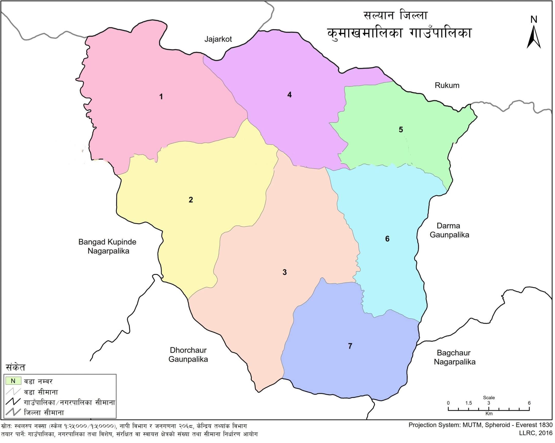
Kumakh covers about 177.27 square kilometres. The elevation ranges from about 440 metres to 2,000 metres above sea level in the overview data, while another section records the range from around 900 metres to 2,000 metres.
The area has a temperate climate, with climatic variation from warm temperate to cold temperate conditions because of its elevation range. The maximum temperature is recorded between 28.2°C and 31.2°C around Jestha–Ashadh. Around Poush–Magh, the minimum temperature is recorded at 2.2°C, with the maximum reaching up to 26.4°C.
Average rainfall is recorded up to around 1,840–1,850 mm.
Kumakh Rural Municipality is divided into seven wards. The ward adjustment from former VDC areas is as follows:
| Ward | Former VDC Area | Former VDC Ward Numbers |
|---|---|---|
| Ward 1 | Swekot | 4–8 |
| Ward 2 | Swekot | 1–3, 9 |
| Ward 3 | Marmaparikanda | 1–9 |
| Ward 4 | Kalagaun | 1, 3–5 |
| Ward 5 | Kalagaun | 2, 6–9 |
| Ward 6 | Wadagaun | 1–9 |
| Ward 7 | Jimali | 1–9 |
The settlements of Kumakh are spread across all seven wards.
Dhandagaun, Sittaljharana, Bhittiyan Chaur Tatke, Madhyani, Tuwagaun, Dhala, Patekholaa, Kot, Nathgawa, Aapchaur, Khamaale, Swekot Pata, Solighari, Waunwada, and Basnetwada.
Sadadaketi, Kanda, Kenkada, Rumalgade, Waste, Khayrukhola, Waungaun, and Suwawahunda.
Khajuwa Chaur Tol, Kholachaur, Ragi, Timile, Chinali, Garagada, Banggegadha, Marmaparikanda, Devikhola, and Dukurpani Chaur.
Kalagaun, Kharigada, Basnet Jigaun, Garagada, Kashi, and Wada.
Thapale, Tallothari, Khorkhola, Neta, Timilakanda, Timile, Kalikhola, and Jyadaudapa.
Chiyanakanda, Golchupar, Jyaukhola, Sheragaun, Wadagaun, Mentakura, Kotwada Bastiwal, and Thapachaur.
Nyupat, Dhandagaun, Kotbara, Lugare, Tile, Paichakhola, Patekhor, Syanijimali, and Darakhola.
According to the 2021 census figures included in the municipal data, Kumakh Rural Municipality has a population of 24,859. The population includes 12,094 males and 12,765 females.
The population density is about 140 people per square kilometre. The literacy rate is reported at 74.98 percent.
Kumakh has forest land, agricultural land, settlements, and open land. Of the total area of 177.27 square kilometres, around 100 square kilometres is covered by forest. Agricultural land is recorded at about 72.935 square kilometres in one section of the available data.
Agriculture remains an important livelihood in the municipality. Paddy is cultivated along riverbank areas. Other food crops include wheat, maize, mustard, gram, and lentils.
Major fruits include banana, mango, papaya, litchi, guava, pear, lemon, apple, and peach. Vegetable crops include bottle gourd, bitter gourd, potato, radish, mustard greens, cauliflower, okra, eggplant, cowpea, pumpkin, tomato, chili, cabbage, cucumber, beans, garlic, and onion.
Kumakh Khola is identified as the main river of the rural municipality. The area also includes other streams, surface water, and underground water resources.
Kumakh Khola extends through nearly 13 small and large streams. Around this river area, the available municipal details record 440 types of plants, 10 types of fish species, 48 species of migratory birds, nine species of butterflies, and two species of reptiles.
The area is also associated with plants such as satisal, saj, and khayer.
People in Kumakh Rural Municipality celebrate festivals connected with local social, cultural, and religious life. Major festivals include New Year, Buddha Jayanti, Raksha Bandhan, Krishna Janmashtami, Teej, Dashain, Tihar, Nwagi, Maghe Sankranti, Shivaratri, and Fagu or Holi.
Dashain and Tihar are among the major festivals of the Nepali Hindu community. Buddha Jayanti is observed by Buddhist communities. Maghe Sankranti is also celebrated by the Tharu community as a New Year festival.
Nwagi is associated with bringing in new grain. Fagu or Holi is observed as a festival of colors.
Kumakh Rural Municipality has public and private schools across its wards. The available education data records 51 total institutions, including 48 public schools, 3 private schools, 1 TECS institution, and 2 technical schools.
School-level distribution includes:
| Level | Grade | Number |
|---|---|---|
| Pre-school | ECD | 49 |
| Basic | Grades 1–8 | 50 |
| Secondary | Grades 9–12 | 11 |
| +2 | Grades 11–12 | 4 |
Schools in Kumakh include Shree Narayan Secondary School, Janata Secondary School Ragechaur, Shree Buddha Janakalyan Madhyamik Vidhyalaya, Mahendra Secondary School Jimali, Bheri Secondary School Tatke, Saraswati Secondary School Jharkanda, Janakalyan Secondary School Badagau Kot, Araniko Secondary School, Bhairabi Secondary School Ramri, and Secondary School Gurudase.
Private schools recorded in the available school list include Salyani Educational Academy, Kumakh Academy, and New Bright Future Academy.
| Institution - Location | Level | Type |
|---|---|---|
| Shree Narayan Secondary School, Rumalgaun - Rumalgaun, Kumakh-2, Salyan | Nursery - 12 | Public |
| Janata Secondary School, Ragechaur - Ragechaur, Kumakh-3, Salyan | Nursery - 12 | Public |
| Shree Buddha Janakalyan Madhyamik Vidhyalaya - Meltakura, Kumakh-6, Salyan | Nursery - 12 | Public |
| Mahendra Secondary School, Jimali - Thuli Jimali, Kumakh-7, Salyan | Nursery - 12 | Public |
| Bheri Secondary School, Tatke - Tatke, Kumakh-1, Salyan | Nursery - 10 | Public |
| Saraswati Secondary School, Jharkanda - Kumakh-5, Salyan | Nursery - 10 | Public |
| Salyani Educational Academy - Kumakh, Salyan | Nursery - 5 | Private |
| Janakalyan Secondary School, Badagau Kot - Badagaun, Kumakh-6, Salyan | Nursery - 10 | Public |
| Araniko Secondary School - Kotnaula, Kumakh-4, Salyan | Nursery - 10 | Public |
| Kumakh Academy - Ragechaur, Kumakh-3, Salyan | Nursery - 5 | Private |
| Bhairabi Secondary School, Ramri - Ramri, Kumakh-3, Salyan | Nursery - 10 | Public |
| Secondary School, Gurudase - Gurudase, Kumakh-3, Salyan | Nursery - 10 | Public |
| Adarsha Basic School, Basnetjyula - Basnetjyula, Kumakh-4, Salyan | Nursery - 8 | Public |
| Kalika Basic School, Timile - Timile, Kumakh-3, Salyan | Nursery - 8 | Public |
| Adharbhut Basic School, Neta - Neta, Kumakh-5, Salyan | Nursery - 8 | Public |
| Bal Jagrit Basic School, Bahunchar - Kumakh-3, Salyan | Nursery - 8 | Public |
| Basic School, Birkeneti, Turture - Kumakh-7, Salyan | Nursery - 8 | Public |
| Saraswati Secondary School, Bhitrivan - Bhitiban, Kumakh-1, Salyan | Nursery - 10 | Public |
| Triveni Basic School, Seradanda - Seradanda, Kumakh-4, Salyan | Nursery - 8 | Public |
| New Bright Future Academy - Kumakh-5, Salyan | Nursery - 5 | Private |
| Janata Basic School, Syanijimali - Syani Jimali, Kumakh-7, Salyan | Nursery - 8 | Public |
| Siddha Basic School, Seripata - Seripata, Kumakh-3, Salyan | Nursery - 8 | Public |
| Jana Kalyan Basic School, Bhandarkhola - Bhandarkhola, Kumakh-4, Salyan | Nursery - 5 | Public |
| Ujjal Basic School, Bukainadanda - Bukainandanda, Kumakh-5, Salyan | Nursery - 5 | Public |
| Kalika Basic School Seragaun - Shanti, Kumakh-6, Salyan | Nursery - 5 | Public |
| Shanti Basic Pra. Vidyalaya Lakhuridada - Lakhuridanda, Kumakh-5, Salyan | Nursery - 5 | Public |
| Bishnu Basic School, Marmaparikanda - Marmaparikanda, Kumakh-3, Salyan | Nursery - 5 | Public |
| Janajagrit Basic School, Thadara - Thadara, Kumakh-4, Salyan | Nursery - 8 | Public |
| Bal Kalyan Basic School - Naranyantakura, Kumakh-2, Salyan | 1 - 5 | Public |
| Shanti Basic School, Thapachaur - Thapachaur, Kumakh-1, Salyan | Nursery - 5 | Public |
| Chakra Basic School, Golakpur - Tallo Golakpur, Kumakh-6, Salyan | Nursery - 5 | Public |
| Bal Kalyan School, Jayapokhari - Jayaphokari, Kumakh-5, Salyan | Nursery - 5 | Public |
| Kalika Basic School - Kumakh-6, Salyan | Nursery - 5 | Public |
| Bhagawati Basic School - Malika, Kumakh-6, Salyan | Nursery - 5 | Public |
| Bal Bikash Basic School - Dandatakuri, Kumakh-3, Salyan | Nursery - 5 | Public |
| Prakirtik Basic School, Hileturture - Kumakh-7, Salyan | Nursery - 3 | Public |
| Mahendra Basic School - Kumakh-1, Salyan | Nursery - 4 | Public |
| Mahadev Basic School, Kainkanda - Kaindanda, Kumakh-2, Salyan | Nursery - 3 | Public |
| Gyanjyoti Basic School, Churabot - Chyurabot, Kumakh-7, Salyan | Nursery - 3 | Public |
| Bal Kalyan Basic School, Timele - Timile, Kumakh-5, Salyan | Nursery - 5 | Public |
| Jana Kalyan Basic School - Kotri, Kumakh-4, Salyan | Nursery - 5 | Public |
| Upakar Basic School, Jimali - Kumakh-7, Salyan | Nursery - 3 | Public |
| Malika Basic School, Barule - Barule, Kumakh-2, Salyan | 1 - 5 | Public |
| Prachalit Smiti Basic School - Kalagaun, Kumakh-5, Salyan | Nursery - 5 | Public |
| Bal Kalyan Basic School - Pimakatiya, Kumakh-6, Salyan | Nursery - 3 | Public |
| Kalika Basic School, Sadhanmudha - Sadhanmudha, Kumakh-1, Salyan | Nursery - 3 | Public |
| Shanti Basic School, Tharakhola - Kumakh-7, Salyan | Nursery - 5 | Public |
| Ganesh Basic School, Thapachaur - Thapachaur, Kumakh-6, Salyan | Nursery - 3 | Public |
| Janata Basic School, Thala - Thala, Kumakh-1, Salyan | Nursery - 3 | Public |
| Saraswati Basic School, Imilechaur - Imilechaur, Kumakh-7, Salyan | Nursery - 3 | Public |
| Nabhasandesh Balbikash Kendra - Kumakh, Salyan | Nursery - Nursery | Public |
Kumakh Rural Municipality functions as a local government body for its residents. Its administrative centre is located at Ward No. 3, Ragechaur. Local public services are connected with ward administration, municipal administration, and local development functions.
For service-related information, see Kumakh Rural Municipality Local Government Services.
Kumakh Rural Municipality is located in Salyan District of Karnali Province, Nepal.
The administrative centre of Kumakh Rural Municipality is Ward No. 3, Ragechaur.
Kumakh Rural Municipality has seven wards.
Kumakh Rural Municipality covers about 177.27 square kilometres.
According to the 2021 census figures included in the available municipal data, Kumakh Rural Municipality has a population of 24,859.
Kumakh Rural Municipality was formed by incorporating the former Swikot, Kalagaun, Marmaparikanda, Badagaun, and Jimali Village Development Committees.
Kumakh Khola is identified as the main river of Kumakh Rural Municipality.









.jpg)