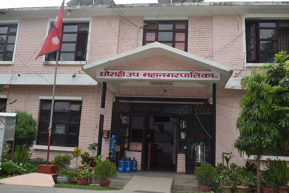
Ghorahi Sub-Metropolitan City (घोराही उपमहानगरपालिका) is a local government unit in Dang District of Lumbini Province, Nepal. It is located in the eastern part of Dang Valley and covers 522.21 square kilometers.
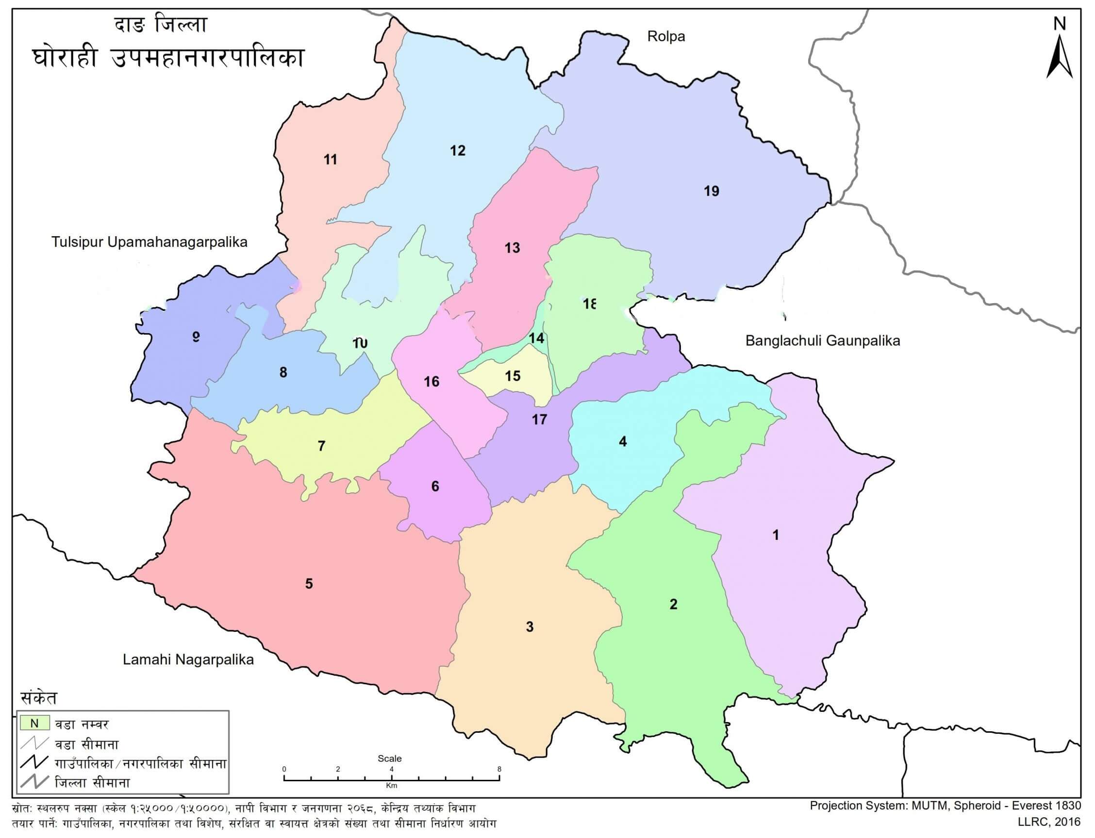
The sub-metropolitan city has 19 wards and serves as the district headquarters of Dang. It is bordered by Bangalachuli Rural Municipality to the east, Tulsipur Sub-Metropolitan City to the west, Lamahi Municipality to the south, and Rolpa District to the north.
According to the 2021 census, Ghorahi Sub-Metropolitan City had 49,761 households and a total population of 200,530. The municipality includes urban, semi-urban, and rural settlements, along with schools, colleges, public spaces, rivers, parks, playgrounds, religious sites, and local cultural areas.
| Field | Details |
|---|---|
| Service Area | Ghorahi Sub-Metropolitan City |
| Nepali Name | घोराही उपमहानगरपालिका |
| District | Dang |
| Province | Lumbini Province |
| Area | 522.21 square kilometers |
| Total Wards | 19 |
| 2021 Population | 200,530 |
| 2021 Households | 49,761 |
| Administrative Role | District headquarters of Dang |
| Linked Service Page | Ghorahi Sub-Metropolitan City local government services |
Ghorahi Sub-Metropolitan City is organized into 19 wards. These wards cover former local units including Rampur VDC, Laxmipur VDC, Dharna VDC, Saudiyar VDC, Tripur Municipality, Ghorahi Municipality, and Saigha VDC.
The ward structure connects settlements across the municipality with local-level administration. Ward 15 had the highest population in the 2021 census, with 29,044 residents. Ward 1 had 4,987 residents, while Ward 19 had 5,909 residents.
Ghorahi Sub-Metropolitan City lies in Dang District in the central part of Lumbini Province. It is spread across the eastern part of Dang Valley and includes areas connected with the Chure and Mahabharat ranges.
The municipality borders Bangalachuli Rural Municipality to the east, Tulsipur Sub-Metropolitan City to the west, Lamahi Municipality to the south, and Rolpa District to the north.
The 2011 census recorded 35,419 households and a population of 156,164 in Ghorahi Sub-Metropolitan City. The 2021 census recorded 49,761 households and a population of 200,530.
The 2021 population included 46.8 percent male and 53.2 percent female residents.
Ghorahi Sub-Metropolitan City has schools, colleges, technical schools, and other educational institutions. The municipality has 14 colleges, including 7 private colleges, 6 public colleges, and 1 technical school.
The school statistics include public, private, religious, TECS, technical, and private nonprofit schools.
| Category | Number |
|---|---|
| Public Schools | 99 |
| Private Schools | 77 |
| Religious School | 1 |
| Private Nonprofit School | 1 |
| Model School | 1 |
| TECS | 2 |
| Technical Schools | 14 |
| Level | Grade | Number |
|---|---|---|
| Pre-school | ECD | 169 |
| Basic | Grades 1–8 | 170 |
| Secondary | Grades 9–12 | 78 |
| +2 | Grades 11–12 | 37 |
The 2021 census recorded the literacy rate of Ghorahi Sub-Metropolitan City at 83 percent. Male literacy was 89.6 percent, and female literacy was 77.4 percent.
Ghorahi Sub-Metropolitan City includes settlements across all 19 wards. The central market, market areas, and older settlements have developed with road networks and access to public facilities.
Major settlements and local areas include Rampur, Laxmipur, Dharapani, Saudiyar, Narayanpur Bazaar, Bangaun, Bus Park, Bharatpur, Sarra, Chogra, Ghorahi, and Saigha.
The municipality’s settlement pattern includes both growing urban areas and ward-level villages and toles.
Ghorahi Sub-Metropolitan City has rivers, streams, ponds, and other water bodies across different wards. These water sources support the local aquatic ecosystem, livestock, birds, and irrigation.
Major rivers and streams include Babai Khola, Bhaise Khola, Katuwa Khola, Sisne Khola, Jahrawa Khola, Sarena Khola, Sewar Khola, Gune Khola, Hapur Khola, Patre Khola, and Andariya Khola.
The document also notes concerns related to erosion, burial, drying of water sources, land-use change, temperature rise, climate change, human activity, and excessive grazing. Conservation and proper management of water bodies are linked with drinking water, irrigation, and local environmental needs.
Water sources in Ghorahi Sub-Metropolitan City support local farming and livestock. Rivers, streams, and ponds provide habitat for aquatic animals and birds while also supporting irrigation for farmers.
This makes water source conservation relevant to agriculture, livestock, and local resource management within the municipality.
Ghorahi Sub-Metropolitan City has parks, picnic spots, religious areas, and recreational sites in different wards. These spaces are used for recreation, fairs, tourism, religious activities, and community gatherings.
Major sites include:
Thanti Darai Month, Ward 1
Sadakghar, Ward 4
Dharapani, Ward 5
Barahkune Daha, Ward 5
Jamire Daha, Ward 13
Shahid Lakhan Thapa Park, Ward 14
Chogora, Ward 18
Goraksha Ratnanath Temple, Ward 18
Sisnekhola Charudhan, Ward 13
Okhariberi, Ward 13
Baran Madyawara, Naynivar, Ward 13
Suryak Park, Telawa Pakha Gurje, Ward 13
Barahkune Daha covers 13 hectares. Shahid Lakhan Thapa Park covers 0.0065 square kilometers. Baran Madyawara, Naynivar covers 0.0132 square kilometers, while Suryak Park covers 0.0155 square kilometers.
Ghorahi Sub-Metropolitan City has playgrounds and open spaces used for sports and recreation. Some school areas also have playgrounds.
| Playground | Type | Area | Ward | Use Status |
|---|---|---|---|---|
| Smriti Cricket Ground | Cricket ground | 3 bighas | 2 | All |
| Football Ground | Football ground | 0.0046 square kilometers | 15 | All |
| Cricket Ground | Cricket ground | Not specified | 17 | Youth club |
Public rest houses, pati, pauwa, chautaras, waiting shelters, wells, taps, dharmashala, and other public structures are part of the municipality’s community assets. These structures are used for rest, public discussion, community interaction, and religious activity.
Identified public shelters and chautaras are located in areas including Simalatara, Kapurkuti, Rampur Chowk, Laxmipur Chowk, Musegaun Chowk, Sodiyar Chowk, Narayanpur Bazaar, Hapur Chowk, Bus Park, Traffic Chowk, Tulsipur Chowk, Sarra Chowk, Chogra Chowk, Masina, and Saigha Chowk.
Ghorahi Sub-Metropolitan City has religious and tourist sites across different wards. These sites are connected with local culture, fairs, festivals, and community activity.
Major sites include:
Thankot, Ward 4
Pandaveshwar Shiva Temple, Ward 5
Barahkune Jaldev Sthan Ganesh, Ward 5
Okhariberi Tourist Site, Ward 13
Barah Area, Barahkune Lake, Ward 13
Om Shanti Sai Temple, Ward 14
Tathya Sai Centre, Ward 14
Ambikeshwari Shivalaya, Ward 15
Siddharatnanath Pith, Ward 17
Ambikeshwari Temple, Ward 18
Kalika Bhagwati Temple, Ward 18
Jaire Stupa, Ward 19
Different communities in Ghorahi Sub-Metropolitan City celebrate local festivals, jatras, and fairs. Major festivals include Dashain, Tihar, Holi, Bhote Jatra, Maghi festival, Gaura festival, Udhauli, and Ubhauli.
| Event | Location | Month | Date or Tithi | Community |
|---|---|---|---|---|
| Barahkune Daha Fair | Ward 13 | Magh | Maghe Sankranti | All |
| Giribire Fair | Ward 17 | Magh | Falgun Krishna Ekadashi | All |
| Dharapani Fair | Ward 5 | Falgun | Shivaratri | All |
| Kathepani Fair | Ward 5 | Kartik | Kojagrat Purnima | All |
| Shirwati | Ward 5 | Magh | 1st day | Tharu |
| Gai Jatra | Ward 14 | Bhadau | Not specified | Newar |
| Maghe Sankranti Fair | Wards 2 and 13 | Magh | Not specified | All |
| Shrimad Bhagwat | Wards 11 and 14 | Magh | Not specified | All |
| Bhume Nach | Ward 14 | From 15 Asar | Not specified | Magar |
| Larena Fair | Ward 9 | Poush | Maghe Sankranti | All |
The far western part of Ghorahi Sub-Metropolitan City has potential limestone availability. Any extraction activity needs assessment of environmental and ecological impact.
Ghorahi Sub-Metropolitan City is located in Dang District of Lumbini Province, Nepal.
Ghorahi Sub-Metropolitan City has 19 wards.
Ghorahi Sub-Metropolitan City covers 522.21 square kilometers.
The 2021 census recorded a population of 200,530 in Ghorahi Sub-Metropolitan City.
Ghorahi Sub-Metropolitan City has schools, colleges, technical schools, and other educational institutions. It has 14 colleges and schools across pre-school, basic, secondary, and +2 levels.
Major rivers and streams include Babai Khola, Bhaise Khola, Katuwa Khola, Sisne Khola, Jahrawa Khola, Sarena Khola, Sewar Khola, Gune Khola, Hapur Khola, Patre Khola, and Andariya Khola.
Major sites include Pandaveshwar Shiva Temple, Barahkune Jaldev Sthan Ganesh, Okhariberi Tourist Site, Ambikeshwari Shivalaya, Siddharatnanath Pith, Ambikeshwari Temple, Kalika Bhagwati Temple, and Jaire Stupa.


.jpg)